


 Country:
 City:


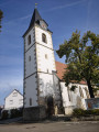
To return to the starting point, head towards Baltmannsweiler, then go to 8 Kirchstraße / Kirchplatz to park near the Aegidiuskirche (St Giles’ Church).
No signposting
(S/E) In front of the church, turn right onto Kirchplatz, then quickly turn left to go round the back of the building. On Brunnenstraße, continue to the junction, then turn left at the signpost towards Schorndorf. Stay on Zinkstraße until you reach the EDEKA supermarket, situated on the corner with the L1150.
(1) Cross the L1150 with care, then carry on straight ahead along the path leading to the Abenteuerspielplatz (adventure playground). Turn right before the playground and head north-west across the fields. At the junction, turn left, then immediately right. Pass a chicken farm and carry on to the junction with the tarmac road.
Signposting: Green arrow indicating a cycle lane
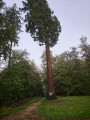
(2) Turn left and continue to the junction with Baacherstraße. Cross carefully, then carry on straight ahead along the stony path that starts near a car park. Walk to the giant sequoia at the junction with Schlößlesplatz.
(3) At the signpost, follow the signs for Essligen to the south-west. Stay on this path, following the signs for Essligen, until you reach the junction with the L1201.
(4) Turn left, cross the L1201 with care, and continue straight on (south-west) along the stony path towards Essligen. Carry on until you reach the junction with the German Way of St James.
Signposting: Yellow Shell on a Blue Background
(5) Leave the Essligen route and turn left (east, south-east) towards Sumpenhof. At the first junction, just ahead, head south-east, turning right. Cross the L1150 with care, then take the wide path leading from the car park. Continue to the three-way junction.
(6) Take the central path heading south-east, following the signposting for the Way of St James. Ignore the side paths until you reach the crossroads at a place called Schinderklinge.
No signposting
(7) Leave the Way of St James and continue along the path on the left (heading south-east). You will arrive at a car park at the entrance to Stumpenhof.
(8) Continue along the road running alongside Schorndorfer Straße on your left and carry on to the junction.
(9) Cross Schorndorfer Straße with care, then turn right onto the footpath that runs alongside the road until you reach the junction.
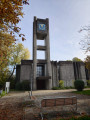
(10) Turn left onto Teckplatz, walk past the cafés and shops towards the church, whose spire you can see. Walk round the left-hand side of the Paul-Gerhardt Church and continue straight ahead along the street until you reach the housing estate’s garages and allotments.
Signposting: Blue Circles on the trees
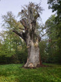
(11) Turn left onto the small grassy path right next to the garages, heading north. Keep going in the same direction as you enter the woods. You’ll come to a crossroads opposite an old dead oak tree, at a place called Hammelstein (there’s a sign with the inscription ‘UHLEICHE’, which means ‘The Owl Oak’).
(12) Continue to the right (south-east) along a wide stony path, then, following the signposts, take the path on the left which descends into the woods. At the junction with a wide stony path, continue down to the left, north-west, until you reach the crossroads.
(13) Turn right (east). After crossing the Schenbach and Lûtzenbah streams in succession, you’ll reach a clearing.
(14) Continue north on the forest track that runs alongside the stream. Ignore the side paths; after a series of bends, you’ll reach a junction with a steep path a few metres past the last left-hand bend.
(15) Turn right onto the steep path leading to an orchard, then continue to the right (north-east) until you reach the junction with a track running parallel to the L1150.
(16) Walk alongside the L1150 to the right for a few metres, then at the signpost, take the path on the right (south-east), following the signs for Batmannsweiller. Walk past the houses on Rosenstraße until you reach the junction with Marienstraße.
(17) Continue along this street until you reach the junction opposite the Baltmannsweiler Town Hall (Rathaus).
(18) Cross Esslinger Straße with care, then walk to the left of the town hall to reach the church, where you will find your car park (S/E).
 Visorando Member

 Easy

 Tourism professional

