OT SDLA

 Tourist office
 Premium user
 Sign up:
Published route(s)
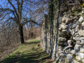
 Roc de Nantbellet
 4.05 mi
 +594 ft
 -587 ft
 2h 25
2h 25
 Easy
Easy
 Departure from Marlens (Haute-Savoie)
A family hike whose route offers a first section in the forest, then panoramic views of the surrounding peaks such as Arclosan, Charvin, Hautes Bauges, Mont Blanc, and the Tamié valley.
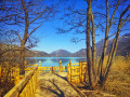
Bout du Lac d'Annecy Nature Reserve
 2.59 mi
+46 ft
-46 ft
1h 15
Easy
Departure from Doussard (Haute-Savoie)
2.59 mi
+46 ft
-46 ft
1h 15
Easy
Departure from Doussard (Haute-Savoie)
Created in 1974 to protect the last reed beds on Lake Annecy, it is home to remarkable flora and fauna. An educational trail takes you around the site in about an hour, through unspoilt natural areas with beautiful views of the nearby peaks of Les Bornes and Les Bauges. You will find magnificent views of the lake, observatories and educational panels.
 Moderate