u Muricintu sheepfold

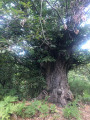
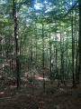
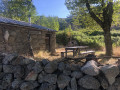
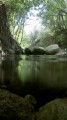
A walk through the hills above Bocognano to reach the u Muricintu sheepfold. After a long climb through chestnut and beech woods, followed by a section along the ridge, you will reach the sheepfold beside a stream and in the cool shade of the alders.

Details

37346961
Creation:
Last update:
Last review:
  • Walking
    Activity: Walking
  • ↔
    Distance: 4.96 mi
  • ◔
    Average duration: 4h 05 
  • ▲
    Difficulty: Moderate

  • ⚐
    Back to start: Yes
  • ↗
    Ascent: + 2,031 ft
  • ↘
    Descent: - 2,001 ft

  • ▲
    Highest point: 4,052 ft
  • ▼
    Lowest point: 2,100 ft
  • ⚐ Country: France
  • ⚐ City: Bocognano (20136)
  • ⚑
    Start/End: N 42.080713° / E 9.057359°
  • ❏
    IGN map(s): Ref. 4252OT, 4252OTR
  • Hour-by-hour weather

Photos

Description of the walk

From Ajaccio, take the T21 then the T20 towards the Col de Vizzavona. Get off at Bocognano. Park in the free car park in the centre of the village, opposite the town hall and the large fountain.

(S/E) With your back to the town hall, walk to the right and then right again along the road that climbs between the bar and the town hall, then turn left towards the hamlet of Quarciolu. At the next junction, head towards Pitraghjolu by taking the first right up the dead-end road.

(1) The path starts on the left, just before you enter the hamlet. Don’t forget to close the gate behind you.

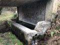
(2) Shortly after setting off, on the right, a fountain – a funtana à l’Aghjola – provides a chance to fill your water bottle before tackling the climb. Follow the cairns heading due south and the orange markings up to the ridge.

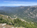
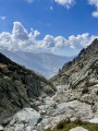
(3) You’ll reach the ridge, Punta à u Coddu, with views of Punta d’Isa and the Col de Scalella. Continue to the left and follow the ridge line until you reach a junction.

(4) Follow the path down to the right, then turn left at the rocky outcrop towards the Bergerie d’u Muricintu.

(5) At the sheepfold, continue towards the spring, which lies about a hundred metres below.

(6) Fill your water bottle and return to the starting point by following the same route in the opposite direction (S/E).

Waypoints

  1. S/E : mi 0 - alt. 2,100 ft - Place du 9 Septembre – Funtanò - Ecomusée U Palazzu
  2. 1 : mi 0.56 - alt. 2,326 ft - Start of the trail
  3. 2 : mi 0.65 - alt. 2,356 ft - Funtana à l’Aghjola
  4. 3 : mi 2 - alt. 3,917 ft - Punta à u Coddu
  5. 4 : mi 2.13 - alt. 4,032 ft - Junction towards the sheepfold
  6. 5 : mi 2.39 - alt. 3,999 ft - u Muricintu sheepfold
  7. 6 : mi 2.48 - alt. 3,967 ft - Source
  8. S/E : mi 4.96 - alt. 2,100 ft - Place du 9 Septembre – Funtanò - Ecomusée U Palazzu

Notes

A walk featuring a steep climb through the trees, which will require considerable effort.
There are water sources along the way.

Worth a visit

You can continue the walk towards the i Purcileddi sheepfolds or the i Spilonchi sheepfold.

Reviews and comments

5 / 5
Based on 2 reviews

Reliability of the description
5 / 5
Ease of following the route
5 / 5
Route interest
5 / 5
Cucunella
Cucunella

Overall rating : 5 / 5

Date of your route : Sep 07, 2026
Reliability of the description : ★★★★★ Very good
Ease of following the route : ★★★★★ Very good
Route interest : ★★★★★ Very good
Very busy route : No

I went on this walk in early September. It’s perfectly possible to park in the car park indicated by Visorando. You can also park as close as possible to point 1, but you’ll then have to park alongside the road.

The route is very well signposted and easy to follow. However, bear in mind that the sheepfolds are just under 4 km from the start — about 3.72 km — with an elevation gain of nearly 600 m: it’s practically all uphill on the way there… and all downhill on the way back!

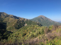
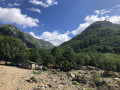
Much of the ascent takes place under the trees, which provides some shade. Afterwards, the path becomes more open out on the ridges, but the view is absolutely magnificent.

On arrival at the sheepfolds, a table and benches allow you to settle down comfortably to have a bite to eat and enjoy the surroundings. In early September, there were also plenty of blackberries along the route.

As for water, a spring was flowing at the start of the route, roughly in the first quarter of the way. However, the other two springs — one halfway along the route and the other near the sheepfolds — had run dry at that time of year. It is therefore essential to bring enough water with you.

A fairly short walk in terms of kilometres, but challenging due to the continuous climb. The effort is more than rewarded by the beauty of the view!

Machine-translated

User 30389201

Overall rating : 5 / 5

Date of your route : Aug 17, 2026
Reliability of the description : ★★★★★ Very good
Ease of following the route : ★★★★★ Very good
Route interest : ★★★★★ Very good
Very busy route : No

A lovely walk in the shade of the chestnut trees and in utter tranquillity. There is a slightly more challenging section (especially on the descent, as the dry ground is slippery). Magnificent views.

Machine-translated

Other walks in the area

For more walks, use our search engine .

The GPS track and description are the property of this route's author. Please do not copy them without permission.