Tour and ascent of Gros Cerveau Ollioules

A beautiful hike in the hills above Ollioules and Sanary, off the beaten track. Exceptional views of the coastline from La Ciotat to Porquerolles, and inland from La Cadière-d'Azur to Le Revest, the Sainte-Baume mountain range and the Ollioules gorges.
The hike alternates between shaded sections in the Mediterranean scrub and sunny sections on the limestone rocks of the La Colle massif.
See important notes in Practical Information.

Technical sheet

98197
Creation:
Last update:
Last review:
  • Walking
    Activity: Walking
  • ↔
    Distance: 9.25 km
  • ◔
    Average duration: 3h 40 
  • ▲
    Difficulty: Moderate

  • ⚐
    Return to departure point: Yes
  • ↗
    Vertical gain: + 363 m
  • ↘
    Vertical drop: - 359 m

  • ▲
    Highest point: 440 m
  • ▼
    Lowest point: 140 m

Photos

Description of the walk

This description is useful but not essential if you have a map and a good sense of direction!

The trail starts near the water treatment plant, in the car park of the Ollioules astronomical observation site and a large fitness trail. Park your car in the first dirt car park on the left of the road (enter between two large stones; there is a blue line on the stone on the right).

(S/E) Directly from the car park entrance, to the south of the fitness trail, look for a simple red and white barrier that opens onto the Bonnet valley (not visible from the road, so look carefully to the south!).
Take the blue-marked path that descends into the valley towards the west.
The path overlooks Les Esquières on the left.

(1) It ends at a fork above the place called Le Lançon.
Turn right onto the fairly steep path (still marked in blue), which then begins to wind its way through the woods.

(2) Follow the wide bends to reach the D20.
Turn left and continue along this paved road for a few hundred metres.

(3) Join the sunken path closed by a green barrier on the right, which leads to the fort (1.3 km).
Even if you are tempted to reach the fort quickly, do not take this path on the right (it is very long and of no interest) but continue along the short paved road.

(4) This will take you to a cistern at the foot of the cliff.
The arrival at the fort is then much better than if you take the direct path.
Turn right and follow the path along the edge of the northern cliff, which is marked in blue, but also in red and white as it is part of the GR®51. You will walk through beautiful sharp limestone pavement, rocks and pebbles laminated by erosion caused by runoff.
You will overlook the Jaume or Val d'Arren quarry on your left, framed by the Gros Cerveau to the south and the Barrière de la Jaume to the north. The almost 270° view is already breathtaking! In the background, you may be lucky enough to see the Sainte Beaume massif with its characteristic foothills.

Reach the summit where you will find thefirst orientation table facing inland. But you will also discover a breathtaking view of the coastline.
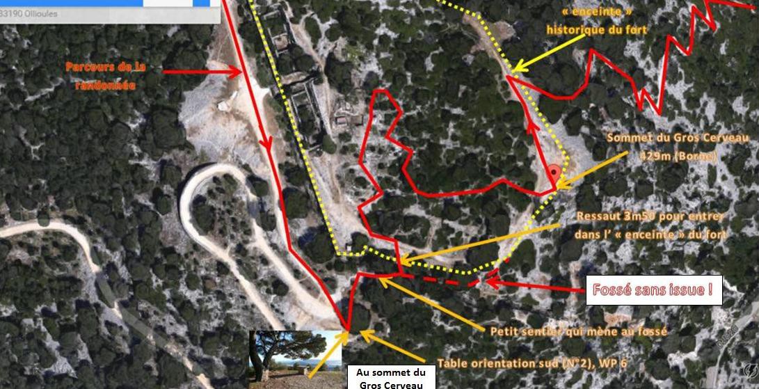
Shortly afterwards, you will enter the site of the Gros Cerveau fortifications.

(5) At the fork, on the left of the path, there is a small footbridge and a small cave, marked "military terrain", and the GR®51, which bypasses the fort to the north (and also allows you to enter it). Continue straight ahead towards the south, on the sea side, along the western wall, which passes in front of the entrance to the fortified section comprising the soldiers' living quarters.
These structures are not open to the public, although they are partially in ruins. On the right, still on the sea side, you can see the top of a blockhouse. Continue to follow the perimeter wall.

(6) You will come to asecond orientation table at the southernmost point of the plateau, facing the sea.
Here you have an exceptional view of the coastline from La Ciotat to Porquerolles. Its location, slightly set back from the Faron and quite far from the city of Toulon, adds a wilder, more Provençal feel than at the summit of its neighbouring peak, the Faron.

After the orientation table, turn around and look for the square watchtower flanking the corner of the rampart.
Then take the small path on the right, marked with a blue cross, and easily reach the bottom of the eastern ditch (a natural ditch that completely replaces the ditch/ramparts found elsewhere to the south and east).
Cross this ditch, climb over a small, easy 3.5 m ledge (where you will need to use your hands, which is great fun for children and completely safe) and you will reach the interior of the fort. The above directions should be sufficient, but if you are having difficulty, here is a photo( No. 27409 ) showing a very detailed aerial view.

Alternative: for the less agile or more cautious, go around the fort to the north, starting from WP5, or to the south and east from WP6 (orientation table).
The route inside the fort is completely open and you do not have to follow the GPX track."

You can then wander around the fort.

Finally, head north-east to the end of the plateau, not far from the summit altitude marker.

NB: due to the large amount of information at the summit, the 1:25,000 IGN map is not very legible, whereas on visorando, the zoomed geoportal-ign version clearly shows a circular path inside the fort, allowing you to reach the start of the descent and then the altitude marker by turning anti-clockwise from thesecond orientationtable. This enlarged view of the area on Google Maps can be seen in the photo portfolio (No. 27409).

(7) 80 m from the summit marker, to the north-east, find the GR®51 trail, marked in red and white and also in blue, which descends rapidly, avoiding the first hairpin bends of the road.
This path is magnificent!

Stay on the road for a short while.

(8) At elevation 311, turn left, leaving the road and the GR®51 (to limit the distance on the paved road and enjoy the Mediterranean pine forest as much as possible), and take a path on the left behind the large green tank with graffiti. You will then walk along the edge of the cliff overlooking the quarry, north of elevation 352.
The path then narrows considerably.

(9) At the first crossroads, take the path on the left for a few dozen metres, then - stay alert! - quickly turn right after a small cairn, onto a narrow path through the scrub. This path winds its way downhill and rejoins the hairpin bend in the road below.
NB: if you miss this path, don't panic, there are other paths criss-crossing the area. You can hear the cars on the road below very clearly, which can also guide you!

(10) Continue on the left until you reach elevation 285 and rejoin the GR®51 (red/white markings). Follow the GR® which leaves the main road on the left (behind the Société du Canal de Provence barrier) onto a short stretch of tarmac road.

A few metres before reaching the Hugueneuve cistern behind its wire fence, turn left into the woods (red/white markings) onto the GR®51, which descends towards the rear of the water treatment plant. The path overlooks the Reppe valley.

Go around it and return to the starting point in the car park (S/E).

Waypoints

  1. S/E : km 0 - alt. 227 m - 2955 Route du Gros Cerveau - 1st car park on the left
  2. 1 : km 2.6 - alt. 212 m - Fourche - Turn right
  3. 2 : km 3.16 - alt. 297 m - Junction with the D20 - Turn left
  4. 3 : km 3.91 - alt. 360 m - Panorama south Gros Cerveau - Stay on the road to the left
  5. 4 : km 4.3 - alt. 351 m - High cistern of Gros Cerveau - Turn right
  6. 5 : km 5.14 - alt. 429 m - Fork at the entrance to the fortified structure - Turn right
  7. 6 : km 5.44 - alt. 419 m - Turn around and go straight ahead, slightly to the left.
  8. 7 : km 5.88 - alt. 430 m - Back on the GR51 - Turn right
  9. 8 : km 7 - alt. 312 m - Cistern at elevation 311 - Turn left
  10. 9 : km 7.38 - alt. 336 m - Intersection - Turn left, then quickly right.
  11. 10 : km 7.89 - alt. 286 m - Cote 285 - Turn left and follow the GR - Reppe (river)
  12. S/E : km 9.25 - alt. 227 m - 2955 Route du Gros Cerveau - 1st car park on the left

Practical information

Hike completed on 25 January 2015 and 3 November 2015 in 2½ hours (but duration calculated by Visorando as 4 hours).

Important
Please note that although the destination is a popular Sunday walk, the entire hike is not suitable for "Sunday walkers". You need to be in good physical condition for the climb, be able to ignore the signs that want to guide you faster than planned to the supposed destination (the fort), and have a good sense of direction so you don't get lost in the scrub on the way down.
This is a real hike (even if it is quite short)!
A compass, a map, this description, a GPS and/or the Visorando app on your smartphone should help you avoid any inconvenience.

Dogs are not allowed, even on a leash, on any part of the trail.

Wear sturdy hiking boots due to the uneven terrain and scree. For those who are sensitive to scratches, beware of the usual thorny Mediterranean scrub that can scratch your calves. Consider wearing trousers or gaiters!

There are no water sources on the hike. Bring plenty of water, even in winter.

In case of rain, the various woods can be used as shelter, but in the event of a storm, only the ammunition galleries and the small cave of the Gros Cerveau fortified structure can accommodate hikers.

In the nearby area

At the top of Gros Cerveau
The fortified structure was built in 1890. It was designed to defend the harbour of Toulon from invasion from the interior of the country via the Gorges d'Ollioules.
The main barracks could accommodate up to 250 men. Part of it was renovated in 2023 (Sanary Tourisme), but the rest is in ruins.
However, the walls of the barracks and a walled underground shelter that was used as an ammunition store still remain. In 2015, the wall closing off the shelter was partially demolished.
Outside the fort, in front of the main gate, there is also a blockhouse built by the Germans in 1943.
Access to the enclosed area is possible by crossing the moat until you reach the telecommunications pylon (or by taking the GR®51 from the north).
It is common to encounter a herd of goats and billy goats from Le Rove*.
You can walk around the inside of the military structure freely and discover the ten old gun mounts and their passageways, former ammunition stores and the underground ammunition storage shelter.
Before heading back down, be sure to visit the marker at the summit at 429 m!

Everywhere
Feast your eyes on 360° views of green, blue and white Mediterranean landscapes... Fill your nostrils with seasonal scents...

Rove goats
The Rove goat is a French breed of goat native to the Bouches-du-Rhône region. It is one of the so-called "small-scale" breeds. The herd is estimated at around 14,000 females in France since 2014. Its coat is varied in colour, usually brown with white or black spots. It is particularly recognisable by its triangular, twisted horns. This goat accompanied the transhumance of sheep and provided milk for shepherds and lambs that their mothers could not feed, as well as meat, at a time when it was commonly eaten. Today, it is used to clear or maintain inaccessible areas that need to be cleared of vegetation to prevent fires.
Source: Wikipedia

 Always stay careful and alert while following a route. Visorando and the author of this walk cannot be held responsible in the event of an accident during this route.

The GR® and PR® markings are the intellectual property of the Fédération Française de Randonnée Pédestre.

Reviews and comments

4.6 / 5
Based on 101 reviews

Reliability of the description
4.6 / 5
Clarity of route map
4.5 / 5
Route interest
4.7 / 5
Fabfilip
Fabfilip

Overall rating : 4.7 / 5

Date of walk : Jun 16, 2025
Reliability of the description : ★★★★★ Very good
Clarity of route map : ★★★★★ Very good
Route interest : ★★★★☆ Good
Busy trail : No

Part of the GR 58 trail that leads to the big brain under the trees. No difficulty, but the path is rocky.

Automatically translated

MCTOUL
MCTOUL

Hello then for fouado and "the many hikers":
once again a short summary of how to get from point 6 to point 7.
Well, under the pines, at the orientation table, all you have to do is turn around and go down into the ditch of the fort. Slightly to the left, there's a gap where you can climb up and access the interior of the fort completely freely - there's obviously no ban on walking in the old fort.
I'd like to remind you again that the photos include a screen capture of the satellite view showing the precise route to this point between (6) and (7) and this same photo can be seen in the application on the mobile phone in photo number 7. So there's no reason not to find it. It's very easy, and I found it myself without any advice from anyone.
have a good walk
sincerely

Automatically translated

fouado
fouado

Overall rating : 4 / 5

Date of walk : Apr 13, 2025
Reliability of the description : ★★★★☆ Good
Clarity of route map : ★★★☆☆ Average
Route interest : ★★★★★ Very good
Busy trail : No

Difficulty in finding the return route between points 6 and 8... as many hikers have already pointed out.
Otherwise, a pleasant trail with varied scenery.

Automatically translated

Amon-Rê
Amon-Rê
• Last modified:

Overall rating : 4.3 / 5

Date of walk : Feb 04, 2025
Reliability of the description : ★★★★☆ Good
Clarity of route map : ★★★★☆ Good
Route interest : ★★★★★ Very good
Busy trail : No

A walk on a very pleasant mountain (yes, because "mountain" when the highest point is 446 metres, I don't call that a mountain), in a natural setting that will only be denatured by the large Lafarge Granulats France quarry. Quite a horrible sight in this picturesque place. Without that, the hike is worth it... but :
1- I'm a confirmed hiker (not an experienced one) but, as such, I feel I have enough experience to spot the paths to be walked, sometimes even without markings (no paint or piles of stones). However, from point 6 to point 7, despite having downloaded the IGN map (which is very accurate) and the satellite map, I got lost. As has already been pointed out in other comments, finding point 7 is complicated. I went round in circles for a good 15-20 minutes to find it.
2- Between point 7 and point 8, I think you need a certain amount of experience to follow the path without getting lost. It's a "hunter's" path, so it's not much used and not very visible to the untrained eye. So yes, if you do get lost, there are alternatives... but they're all the same type of path! What's the worst that can happen, with the help of the noise of vehicles travelling below on the road? No, definitely not. Easier said than done.
3- The creator of this route talks about the markings: the blue markings sometimes disappear. In this case, you have to use the red markings when you're on the part of the route devoted to the long-distance footpath. In this case, the red paint is clear. So it's been a while since the blue paint has been redone. At the same time, the blue markings do not concern the Fédération Française de Randonnée, which explains why.
4- While some parts of this hike can be used by children, this is not the case for others, where they are likely to have difficulties.

No quid pro quo! The only criticism is my first comment. I think that the author of this route should redo the tracing between point 7 and point 8. It's not clear. The rest are just observations. The fact remains that I enjoyed this hike, which fitted in perfectly with my criteria. In the heart of nature, with a view of the sea and on the other side, as far as the Sainte-Baume, it's a beautiful sight, with a route that, for the most part, is pleasant.

Automatically translated

MCTOUL
MCTOUL
• Last modified:

Hello Aude1401,

Thank you for your interest in my route.
Unfortunately, there is no other path nearby to reach the summit marker and the descent path.
As you can see from this photo attached to the hike: https://www.visorando.com/photo-sommet-gros-cerveau-google-maps.html
Or you'll have to retrace your steps...
Sincerely

Automatically translated

Aude1401
Aude1401

Overall rating : 4.3 / 5

Date of walk : Jan 05, 2025
Reliability of the description : ★★★★☆ Good
Clarity of route map : ★★★★☆ Good
Route interest : ★★★★★ Very good
Busy trail : No

The route is easy to follow, with a few small detours that seemed pointless to me. At the very top, after the goats, it's still difficult to find the path, so you have to climb and climb again to get back on the route. Beautiful hike and superb view . 🥳

Automatically translated

MCTOUL
MCTOUL

I understand.
Going around clockwise is then effectively the possible variant.
Sincerely

Automatically translated

Ladilafee
Ladilafee

Hello ,
I followed the explanations to the letter.
Everything was very clear and perfectly indicated, right up to crossing the ditch, which I tried to do, but without success ...
Perhaps with the weather and the rain it became less practicable.
In any case, I preferred to go round.
Sincerely

Automatically translated

MCTOUL
MCTOUL

Hello Ladilafee,

I'm sorry about your hesitations and your research...
But you're talking about point 6 (and not 10).
Because from point 10 we're already a long way from the summit.

However, I don't see your problem.
From point 6, all you have to do is reach the ditch behind you
"After the orientation table, turn around and look for the square watchtower flanking the corner of the rampart.
Turn right onto the narrow path leading uphill, marked with a blue cross, and you will easily reach the bottom of the eastern moat (a natural moat that completely replaces the moat/wall combination found elsewhere to the south and east).
Cross this ditch, go over a modest and easy 3.5 m rise (where you have to put your hands, a delight for children and absolutely safe) and reach the inside of the fort."

Perhaps you were without the app and without a map?
And perhaps you hadn't seen this photo, which shows the route and its variations?
https://www.visorando.com/images/origina...

Best regards

Automatically translated

Ladilafee
Ladilafee

Overall rating : 4.3 / 5

Date of walk : Dec 01, 2024
Reliability of the description : ★★★★★ Very good
Clarity of route map : ★★★☆☆ Average
Route interest : ★★★★★ Very good
Busy trail : Yes

We had a big problem at point 10 finding the path back down.
We retraced our steps to re-enter the fort without having to cross the ravine.
We turned around for a while...
We weren't the only ones.
In fact, the path leads past the orientation table, past the small bridge on the left "towards the cave", continue for a few metres and it descends to the left.
Quite steep and stony.

Automatically translated

Jpi
Jpi

Overall rating : 5 / 5

Date of walk : Nov 15, 2024
Reliability of the description : ★★★★★ Very good
Clarity of route map : ★★★★★ Very good
Route interest : ★★★★★ Very good
Busy trail : Yes

Hi, it was a very nice hike that we did with a group of 16 people of different levels. They were all delighted. Don't do it if it's raining.
Thank you

Automatically translated

YLep
YLep

Overall rating : 5 / 5

Date of walk : Aug 21, 2024
Reliability of the description : ★★★★★ Very good
Clarity of route map : ★★★★★ Very good
Route interest : ★★★★★ Very good
Busy trail : No

A very nice walk, with beautiful views.

Automatically translated

stephane83500
stephane83500

Overall rating : 5 / 5

Date of walk : Jul 07, 2024
Reliability of the description : ★★★★★ Very good
Clarity of route map : ★★★★★ Very good
Route interest : ★★★★★ Very good
Busy trail : No

Done on 7 July, from point 4 a little aerial to be avoided by people who are really afraid of heights and also in strong winds, otherwise it's easy despite the town hall's warning.
Superb hike with incredible views.

Automatically translated

marquounet
marquounet
• Last modified:

Overall rating : 4.7 / 5

Date of walk : Oct 29, 2023
Reliability of the description : ★★★★★ Very good
Clarity of route map : ★★★★★ Very good
Route interest : ★★★★☆ Good
Busy trail : Yes

After 2 days of rain ... the start was in the mud and that's just as well ... Good course!

Automatically translated

MCTOUL
MCTOUL

Other walks in the area

For more walks, use our search engine .

The GPS track and description are the property of the author. Do not copy them without permission.