Country:
 City:
City:


Start: Hiking car park at the Jägerhaus forest lodge (Binger Wald, 55413 Weiler bei Bingen)
(S/E) From the car park, we walk towards the forest house, turn right and then immediately left. The first highlight awaits us soon after.
(1) From the Morgenbach Valley, into which the long-distance hiking trail leads, we take a short, approximately 200-metre detour through the Steckenschlääferklamm gorge. In addition to several wooden footbridges, each spanning a tiny tributary of the Morgenbach stream, there are numerous carvings on the trees, known as tree spirits.
At the end of the gorge, we turn back and return to the crossroads in the Morgenbach Valley. We turn right and follow the lively stream downstream and deeper and deeper into the narrow gorge. At all junctions, we keep to the left, close to the water. We pass rushing waterfalls and lively waterfalls.
(2) At the Morgenbach refuge, we also keep to the left and continue to follow the stream.
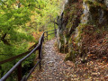
(3) The Soonwaldsteig trail leads past the Kristallspitze and shortly afterwards we leave the Morgenbach valley and keep to the right. Rocky paths lead past rugged slate rock formations up to the heights of the Rhine. Safety ropes are installed in several places to ensure a safe ascent even in wet weather.
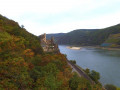
(4) On the hilltop, the view from a rocky outcrop takes in the Rhine Valley and Reichenstein Castle, also known as Falkenburg, which towers above the Rhine village of Trechtingshausen on the eastern slope of the Binger Wald forest.
From this panoramic rock ledge, the Soonwaldsteig trail continues to follow the Eselspfad (donkey path) and stays close to the steeply sloping edge of the valley to the Rhine. At the next two forks, keep left and then turn left.
Gently sloping downhill, the route runs along narrow, natural paths to Rheinstein Castle.
(5) This spur castle also towers above the steep Rhine slope and captivates every visitor to the Middle Rhine Valley. We follow the signs through the steep Rhine slope.
(6) Shortly afterwards, we pass a medieval outpost that offers magnificent views of the Rhine. From here, Rheinstein Castle can be seen in a picture-perfect perspective. On the other side of the Rhine lies Assmannshausen, and further upstream, Bingen, our destination, can already be seen in the distance. The Soonwaldsteig trail runs briefly into the Poßbachtal valley on rocky paths with railings.
(7) Then we pass the Schweizerhaus, continue straight ahead and keep left at the next fork, crossing the Possbach stream.
(8) At the fork behind the stream, keep right and head back up to the Rhine heights. A short side trail leads hikers to the Damianskopf viewpoint.
(9) Here, it's time for another long break to enjoy the magnificent views down the Rhine to Assmannshausen and upstream to Bingen.
From Damianskopf, the Soonwaldsteig trail enters the Hunsrück for the last time. The route leads through sparse deciduous forest to the Heiligkreuz forest lodge, which is located in the middle of the Bingen city forest and is an inviting place to stop for refreshments.
(10) We cross the Kreuzbach stream, cross the road and turn left at the next crossroads. At the next fork, we take the second path on the left, reach the road and keep left. We follow the signs back to the panoramic Rhine heights.
(11) From the Prinzenkopf, we take another long look at the wide Rhine valley. Beyond the river, on the steep vineyard slope, we can see Ehrenfels Castle, and in the middle of the river stands the Mäuseturm. Now it's all downhill.
(12) We pass the youth hostel, turn left behind the school and then right into Koblenzer Straße, reaching Bingen railway station.
(S/E) This is where the last stage of the Soonwaldsteig trail ends.
 Visorando Member
 Difficult