Country:

 City:


Red and white markings on the GRT66
(S/E) From the refuge (alt. 2,185 m), head due south, descending towards the Étangs de l’Estagnol (elevation 2,099 m).
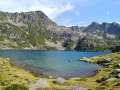
(1) Cross the spillway at the first small lake and head due west through a pile of rocks. Climb, keeping to the mountainside along this difficult marked path. After the 2,124-metre mark, the path turns due south-west. Cross the stream at the spillway of the Étangs de Fontargente and walk along the right-hand side of the large lake. You will reach a fork at its northern end.
(2) Turn left, heading south-west, and reach another unmarked junction.
(3) Continue due south, still keeping the large lake on your left. Much higher up, you’ll reach the Col de Fontargente, on the France–Andorra border ridge at an elevation of 2268 (a vast and beautiful landscape).
(4) Descend on the Andorran side and, much further down, you’ll come to a steel signpost.
(5) Two options:
- Continue straight on, slightly uphill, south-west, towards a steel signpost.
- Turn left and look out for a footbridge further on, on the right, below you.
Off the marked trail
(6) Cross the Riu del Manegor and the wetland, then head uphill towards a steel signpost.
Yellow and redGRP® La Volta a Andorrasignposting
(7) Turn left towards the south-west, heading for the Estany de Cabana Sorda. The path climbs steadily up the mountainside, skirting around it. You’ll reach the Pleta de la Cabana Sorda at around 2,170 m.
(8) Continue on level ground and then resume the north-westerly ascent over rock slabs. Stay well above the Riu de Cabana Sorda stream on your left. Reach a barely visible junction with numerous paths, at the southern corner of Cabana Sorda.
No signposting. End of the GRT66
(9) Carry on straight ahead to reach the beautiful Estany de Cabana Sorda (bench and dry toilets).
(10) A lovely spot, often busy. Turn back south-east for about a hundred metres and pass the hut, leaving it behind.
Markings: yellow dots and cairns
(9) At the corner of this hut, by the mast with the solar panels, you’ll come to a junction of several paths (no signpost).
Look out for a path marked on the ground, heading south-east, which remains level along the mountainside. Follow it for about fifty metres until you reach a barely marked fork.
(11) Leave the path that climbs to the left (north-east). Continue on level ground, keeping to the correct path and following the yellow markings. Then turn due north, climbing slightly, through this beautiful landscape. A little further on, descend to the Estany d’Anrodat below.
(12) A lovely, peaceful spot for a lunch break.
Carry on due north-east and, without crossing the stream at the weir, turn right, following the cairns. You’ll come to a good, clearly marked path and should follow it, keeping a safe distance from the stream.
At around 2,230 m, you’ll reach a fork in the path.
(13) Do not cross the stream, but turn due south, moving away from it.
Caution: take extra care as a very steep descent follows. Take your time and, if necessary, take breaks. Much further down, you’ll reach the steel signpost you passed on the way up.
Unmarked section
(7) Head left, north-east, aiming for the large steel posts to reach the fork which you also passed on the way out.
Red and white markings for the GRT66
(5) Head straight ahead and begin the climb towards the Col de Fontargente.
(4) You may well need a break after this climb.
Retrace your steps along the path you took on the way there to reach the refuge (E)
 Visorando Member

 Moderate