Country:
 City:
City:


Park in the town hall car park, Place Paul Gabillet.
(S/E) Make your way to the town hall fountain, which dates from 1852 and whose water comes from a catchment 800 metres away at the foot of Saint-Hilaire hill. Follow the Grande Rue to the left.
(1) Take the first left onto Rue du Moulin (featuringa washhouse dating from 1924, which was used for rinsing laundry).
(2) At the junction, turn right onto Rue Chaumont (the well in the square is one of the town’s seven public wells). Carry on straight ahead, ignoring the narrow streets on the right, and follow a stream on your right. Note a votive tower at the top of the hill. Walk past the Place des Platanes on your right and you’ll soon come to a junction (the Saint-Nicolas washhouse, dating from 1852, situated in a neighbourhood with numerous springs).
(3) Return to the Grande Rue and follow it to the left. At the crossroads that appears shortly afterwards (calvary), continue roughly straight ahead into Rue Chapelle. After about 250 m, turn right into the street known as Chemin du Milieu. Turn left onto this street and cross the D981with care. Take the path opposite.
(4) After about 150 m, turn right onto a path leading to the old Fontaines quarries. As you enter, note two mounds of earth known as ‘laisses de carrière’ because they were left as they were as they were unworkable by the quarrymen. On the mound of earth on the right, climb a tricky flight of steps to reach the summit and admire the view:when the weather permits, you can see Mont Blanc. Turn left and then, before reaching the quarry face, take the path on the left, which quickly leads to a T-junction.
(5) Turn right and follow a path through the woodland uphill. Walk for some time heading south-west. You’ll come out onto a forest track; follow it to the right for about twenty metres until you reach private property.
(6) Then take a path on the right. Walk north-east until you reach a solitary tree marked with the number 1.
(7) Turn left and head uphill. At the next junction (elevation 301), go straight on and walk alongside a cultivated field. This will take you to the Tour Saint-Hilaire. This is a votive tower, erected in 1862 on the ruins of a priory which, in turn, had been built on the site of a Roman speculum (observatory). At the top of this building, constructed from fine ashlar, stands a statue of the Virgin Mary.
(8) Retrace your steps back to the crossroads with the tree bearing the number 1.
(7) Then turn left (north) and head downhill. Further on, turn left onto the path to go round another old quarry. Wind your way along until you reach a fork in the path.
(9) Follow a path on the right and continue to a forest track.
(10) Follow the track to the right for about 500 m, until you reach a sign for the ‘Chemin Bleu’ on the left.
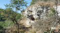
(11) Turn left onto this path marked in red, which immediately turns right. Continue straight on for about 250 metres and then turn right to reach the Saufouret quarrymen’s cave. This cave served as a storeroom and shelter for the quarrymen, some of whom carved their names into the walls.
(12) Retrace your steps back to the “Chemin Bleu” sign.
(11) Then turn left (east).
(13) Cross the D981 with care and take the path opposite.
(14) At the T-junction, turn right. Carry straight on and ignore the first turn-off on the left. As you approach the Saint-Nicolas neighbourhood, turn left (at the corner, there is a typical Burgundian house with horseshoes embedded in the wall).
(3) Join the Grande Rue and follow it to the left. At No. 102, note a house whose construction began just before the Revolution of 1789 and was completed just afterwards. At No. 77, the house of the sculptor Antoine Chauche (1826–1903), creator of several sculptures in the church at Fontaines.At No. 25,an inscription from a husband to his wife: Jesus-Maria. Denie (Denis) Guppillote – Anne Cheureux 1721.
(1) At the junction you passed at the very start of the walk, go straight on to find, immediately on the right, the starting car park (A/D).

 Association / Club / Walk leader
 Easy
Easy 
 Visorando Member
 Difficult