Les Balcons d’Argelès-sur-Mer

The foothills of the Massif des Albères
This hike, with its successive inclines, will take you up to a vantage point overlooking the Roussillon plain and the Mediterranean Sea.

Details

3257208
Creation:
Last update:
Last review:
  • Mountain biking
    Activity: Mountain biking
  • ↔
    Distance: 8.84 mi
  • ◔
    Duration according to the author: 2 hrs 
  • ▲
    Difficulty: Moderate

  • ⚐
    Back to start: Yes
  • ↗
    Ascent: + 1,362 ft
  • ↘
    Descent: - 1,391 ft

  • ▲
    Highest point: 1,207 ft
  • ▼
    Lowest point: 151 ft
  • ⚐ Country: France
  • ⚐
  • ⚐ City: Argelès-sur-Mer (66700)
  • ⚑
    Start/End: N 42.531941° / E 3.029356°
  • ❏
    IGN map(s): Ref. 2549OT

  • ◶
    Type of surface:
  •  
     
     
     33% Road  34% Byway  33% Path
  • ⇧
    Bike carrying: No
  • ▲
    Difficulty: Moderate
  • Hour-by-hour weather

Photos

Description of the route

The starting point is the car park below Château Valmy, surrounded by vineyards.
There is a sign showing the map of mountain bike and walking routes.
The route you should take is Route No. 3 (Red).

(S/E) Head towards the Route de Valmy.

(1) Follow the tarmac road down to the ‘Stop’ sign at the junction and turn left, following the signs for Mountain Bike Route No. 3 (Red). Head towards Les Mimosas campsite.

(2) Before the ford, turn left and take the DFCI-AL42 forest fire prevention track.

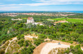
(3) At the three-way junction at Mas Peyrot, head uphill and you’ll soon reach a superb viewpoint overlooking Valmy Castle. Continue for 200 metres along the track

(4). A footpath marked with a hiking sign points towards the Dolmen de la Cova de l’Alarb. Continue straight ahead along the track.

(5) At the fork, carry on straight ahead along this wide track, which winds for a few kilometres through the lush foothills of the cork oak forest in the Massif des Albères. Do not take any of the other tracks or paths.

(6) At the junction where the track meets the tarmac road, turn right (south) to reach Mas Cristina (private property).

(7) At the end of the road, turn right and take track DFCI-AL41. Ignore the footpaths and other tracks branching off to the right or left. You can just make out the farmhouses nestled in their natural setting. The climb becomes steeper for over 3 km, until it reaches its highest point.

(8) At the reservoir (altitude 363 m), turn right towards track DFCI-AL29. This section is pleasant, with a succession of gentle ravines forcing you to descend and then climb again. Always ignore the tracks on both the right and left, as they lead to private property.

(9) A memorial dedicated to airmen has been erected; you’ll see it on your left.

(10) Turn right to continue descending along the winding track.

(11) Keep the track on your left (green water tank) and continue along the DFCI-AL39 track. Join the tarmac road and pass the Les Mimosas campsite (S/E).


Waypoints

  1. S/E : mi 0 - alt. 200 ft - Château de Valmy
  2. 1 : mi 0.1 - alt. 171 ft - Road junction
  3. 2 : mi 0.15 - alt. 157 ft - Fording
  4. 3 : mi 0.4 - alt. 262 ft - Three-way junction, Mas Peyrot
  5. 4 : mi 0.82 - alt. 453 ft - Access to the Cova de l’Alarb dolmen is available
  6. 5 : mi 1.39 - alt. 387 ft - Crossing path
  7. 6 : mi 2.97 - alt. 338 ft - Junction with the tarmac road at Mas Christine
  8. 7 : mi 3.37 - alt. 374 ft - DFCI-AL41 track
  9. 8 : mi 5.4 - alt. 1,188 ft - Water retention basin
  10. 9 : mi 6.75 - alt. 1,027 ft - Memorial to the airmen
  11. 10 : mi 6.81 - alt. 994 ft - Chapelle Saint-Laurent-du-Mont trail
  12. 11 : mi 7.99 - alt. 538 ft - DFCI-AL39 track
  13. S/E : mi 8.84 - alt. 197 ft - Signpost for mountain bike and walking trails - Château de Valmy

Notes

Access: RD 914 – Exit 12 – Route de Valmy – Car park
Mountain bike trail no. 3 (red): Les Balcons d’Argelès-sur-Mer.

(10) Option to make a return trip to the Chapelle Saint-Laurent-du-Mont.

Please ensure you control your speed on descents and take care when passing near residential areas.

Water fountains are available in Valmy Municipal Park:
Annual park opening times:
From 5 February to 30 April, 10.00–18.00 daily.
From 1 May to 30 September, from 10.00 to 19.00 every day.
From 1 October to 6 November, 10.00–18.00 daily.

Temporary closure for the festival: from 6 June to 22 June

Worth a visit

Enquiries: https://www.argeles-sur-mer.com/
Tourist Office: 04 68 81 15 85

Valmy Municipal Park.
To round off your visit to Argelès-sur-Mer, follow the interpretive route which tells the story of the area, the environment of the Albera Massif (vegetation) and local life and culture.

Nature and Sports Centre:
At the visitor centre located at the park entrance, you’ll find all the information you need on the wide range of outdoor activities available in Argelès-sur-Mer. Whether you’re keen on the sea (kayaking, stand-up paddleboarding, diving), the countryside (walking, jogging, hybrid cycling…), or the mountains (hiking, trail running, mountain biking…), you’re sure to find something to suit you!
Centre opening hours: 2 pm to 5 pm (from the February half-term holidays until the end of the All Saints’ Day half-term holidays).
Tel: 04 68 95 34 28

Reviews and comments

4.5 / 5
Based on 2 reviews

Reliability of the description
5 / 5
Ease of following the route
5 / 5
Route interest
3.5 / 5
Mesylda
Mesylda

Overall rating : 4.3 / 5

Date of your route : May 06, 2026
Reliability of the description : ★★★★★ Very good
Ease of following the route : ★★★★★ Very good
Route interest : ★★★☆☆ Average
Very busy route : No

A route designed mainly for mountain biking
I ended up doing it on foot, so the trail is rather monotonous as it’s a wide path for almost the entire route
So it’s ideal for mountain biking or brisk walking, as I did

Machine-translated

laurent-g
laurent-g

Overall rating : 4.7 / 5

Date of your route : May 26, 2022
Reliability of the description : ★★★★★ Very good
Ease of following the route : ★★★★★ Very good
Route interest : ★★★★☆ Good
Very busy route : No

A fairly varied route, with the first section taking you along a balcony path with scenic views, followed by more climbing, and finally a descent with some fast-paced sections. There are a few stony sections (which I’m not too keen on) that require you to be careful where you place your wheels (I was on a hard-tail, which wasn’t very comfortable).
Note that if you take a detour towards the signposted dolmen (towards the top of the route), without going all the way to the dolmen itself, you’ll reach a viewpoint (about 500 metres away).

Machine-translated

For more walks, use our search engine .

The GPS track and description are the property of this route's author. Please do not copy them without permission.