Lac Bleu via the Technopole and Bordeaux-Léognan-Saucats aerodrome

A lovely walk, with ever-changing scenery of woods, vineyards and woodland as you follow the streams. It’s very varied and can be shortened by taking alternative routes.
If you enjoy long walks, you’re in for a treat.

Details

n°9898939
Creation:
Last update:
Last review:
  • Walking
    Activity: Walking
  • ↔
    Distance: 14.28 mi
  • ◔
    Average duration: 6h 40 
  • ▲
    Difficulty: Difficult

  • ⚐
    Back to start: Yes
  • ↗
    Ascent: + 141 ft
  • ↘
    Descent: - 141 ft

  • ▲
    Highest point: 190 ft
  • ▼
    Lowest point: 105 ft
  • ⚐ Country: France
  • ⚐ City: Léognan (33850)
  • ⚑
    Start/End: N 44.723598° / W 0.62144°
  • ❏
    IGN map(s): Ref. 1537SB
  • Hour-by-hour weather

Description of the walk

Park in the car park by Lac Bleu at the side of the road (Chemin des Terres Rousses).

(S/E) Walk back up the road for 100 m to the junction.

(1) Turn right onto Chemin du Prieur. Continue straight on at all the junctions you come to, staying on Chemin du Prieur, until you reach the D 651.

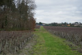
(2) Turn right onto this road (Avenue de Mont de Marsan) and, after 50 metres, take the path running parallel to it through the vineyard.

(3) Turn left onto Chemin du Château Bois-Martin

(4) After following the path through the vineyard, climb the embankment (path on the left) to rejoin the Chemin du Château Neuf until you reach a track.

(5) Turn right onto the track running alongside the Bordeaux-Montesquieu Technology Park.

(6) Cross the road and turn right onto the vineyard track, which runs parallel to the road, then take the Voie Communale No. 19. Continue until you reach a junction.

(7) Turn right onto the Chemin Rural du Pas de Barrau and continue to the D 111.

(8) Cross the road, head right for 50 m and turn onto the track on the left for 200 m. Turn left twice, then right. Just before the D 111, turn right twice and carry on straight ahead until you reach a track.

(9) Follow the track to the right, then, after 100 m, turn left until you reach a road running alongside the aerodrome.

(10) Turn right, then left onto the track.

(11) Cross the road (Avenue de Mont de Marsan) and follow the Chemin des Bougès; then, 400 m further on, take the path on the right. At the end of this path, turn left to rejoin the road.

(12) Follow this road (Chemin des Bougès) to the right for 400 m and, after crossing a junction at Les Bougès, take the Chemin de Caupey on the left for 100 m.

(13) Turn left onto the track (Piste des Bouges).

(14) After passing Véret Blanc, turn left onto the track running alongside the Ruisseau de l’Eau Blanche towards the Piste Anche.

(15) Follow the path to the right until you reach the Piste de Segreyre, which you should follow to the right for 200 m.

(16) At a crossroads, turn left towards the Chemin du Barp track.

(17) Turn left onto the Chemin du Barp, then, 300 m further on, go straight on along the path towards the River Véret Blanc and follow it to the right. Cross the river and continue to a fork in the path.

(18) Turn left onto the path leading to the riding school.

(19) Turn left onto the Piste du Manège and follow it for 500 m. Then turn right at the crossroads.

(20) Turn left onto the track. To shorten the route, go straight on.

(21) Turn right onto the track, Chemin les Fleurs d’Ajoncs.

(22) Turn right onto the track that runs alongside the ‘Les Fleurs d’Ajoncs’ housing estate and the Château Haut-Bergey park, then turn left.

(23) Take the track furthest to the right to the car park (S/E).

Waypoints

  1. S/E : mi 0 - alt. 174 ft - Lac Bleu car park
  2. 1 : mi 0.09 - alt. 174 ft - Chemin du Prieur towards the - Eau Blanche (rivière) - Garonne
  3. 2 : mi 1.07 - alt. 128 ft - Avenue de Mont de Marsan - Château de France
  4. 3 : mi 1.45 - alt. 161 ft - Chemin Château Bois-Martin
  5. 4 : mi 1.81 - alt. 171 ft - Chemin Château Neuf
  6. 5 : mi 2.41 - alt. 180 ft - Technopole Track
  7. 6 : mi 2.98 - alt. 177 ft - Roman Road
  8. 7 : mi 3.73 - alt. 148 ft - Chemin Rural du Pas de Barrau
  9. 8 : mi 4.17 - alt. 171 ft - Roman Road
  10. 9 : mi 5.4 - alt. 187 ft - Forest track
  11. 10 : mi 5.81 - alt. 184 ft - Airfield
  12. 11 : mi 6.7 - alt. 177 ft - Chemin de Bougès
  13. 12 : mi 7.3 - alt. 151 ft - Chemin de Bougès
  14. 13 : mi 7.68 - alt. 148 ft - La Segreyre track
  15. 14 : mi 7.88 - alt. 125 ft - Chemin du Ruisseau
  16. 15 : mi 9.03 - alt. 164 ft - Chemin du Ruisseau
  17. 16 : mi 9.34 - alt. 171 ft - Segreyre track.
  18. 17 : mi 9.78 - alt. 167 ft - Chemin du Barp track
  19. 18 : mi 10.49 - alt. 154 ft - Towards the Manège
  20. 19 : mi 10.91 - alt. 174 ft - Piste du Manège
  21. 20 : mi 11.46 - alt. 190 ft - Forest Path
  22. 21 : mi 12.04 - alt. 187 ft - Chemin les Fleurs d’Ajoncs
  23. 22 : mi 12.74 - alt. 184 ft - Chemin l’Hermitage
  24. 23 : mi 13.68 - alt. 180 ft - Bois du Lac Bleu
  25. S/E : mi 14.28 - alt. 174 ft - Lac Bleu car park

Reviews and comments

3.6 / 5
Based on 3 reviews

Reliability of the description
3.3 / 5
Ease of following the route
3.3 / 5
Route interest
4 / 5
Etevlys
Etevlys

Overall rating : 3.3 / 5

Date of your route : Sep 06, 2021
Reliability of the description : ★★★☆☆ Average
Ease of following the route : ★★★☆☆ Average
Route interest : ★★★★☆ Good
Very busy route : No

Hello,
Having spent a long time studying this part of the route online early this morning – from point 2 to point 11, en route to ‘Technopole and Bx/Saucats Aerodrome’ – everything went smoothly according to the original route details. My only criticism is that there are no specific instructions between points 4 and 5: NOTHING!! I’m following your description and your map route. See you later.

Machine-translated

Etevlys
Etevlys
• Edited:

Hello,
Just to say that I’ll be going back to cover Points 2 to 11 of this walk, and doing the Technopole and Léognan Saucats Aerodrome section, where I really did come unstuck!!!
See you soon

Machine-translated

Etevlys
Etevlys
• Edited:

Overall rating : 3.3 / 5

Date of your route : Aug 17, 2021
Reliability of the description : ★★★☆☆ Average
Ease of following the route : ★★★☆☆ Average
Route interest : ★★★★☆ Good
Very busy route : No

Hello,
I’ve just done this walk. Phew!!
I managed up to point 4. Although, before turning left to get to point 2, I turned right between the vineyards, walked 100 metres and turned left again between the vineyards to reach a wide track of white gravel, and carried on to the Grand Route, crossed it and, on the opposite side, took the track between the vineyards. Much better than walking along the side of the Grand Route.
I found the embankment (path) on the left, followed the Chemin du Château Neuf until I reached the track!! And from there on, everything went a bit haywire. Goodbye to the Bordeaux Montesquieu Technopole (although at one point I did spot a large advertising hoarding in the vineyards with that name on it, but was it…? Bye-bye to the road running alongside the aerodrome, though I could hear the planes making a right racket in the sky… And I found myself at the side of the Chemin des Bougès, which I took, then took the Chemin de Caupey, carried on along the Piste des Bougès, passed the Véret Blanc and took the path to the left. I took the path on the right as far as the Ségr… track – no, the Cassaudière track – and YES!! That wasn’t IT! … I’ll stop there because right up to the end I was in a right mess, though I managed to land on my feet.
WHAT AN ADVENTURE!

Machine-translated

laplage
laplage

Overall rating : 4 / 5

Date of your route : Jul 05, 2021
Reliability of the description : ★★★★☆ Good
Ease of following the route : ★★★★☆ Good
Route interest : ★★★★☆ Good
Very busy route : No

I’m familiar with part of this route as I’m from the area. I can’t say whether it’s very busy or not.

Machine-translated

Etevlys
Etevlys

28 June 2021
Hello: hike TO BE DONE – report TO BE DONE BELOW.
See you soon

Machine-translated

Other walks in the area

For more walks, use our search engine .

The GPS track and description are the property of this route's author. Please do not copy them without permission.