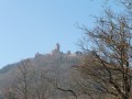
Haut-Koenigsbourg as seen from Saint-Hippolyte

Haut-Koenigsbourg is an icon of Alsace. Some people drive straight to the castle, but a more challenging option starts from the village of Saint-Hippolyte. This medium-difficulty route offers breathtaking views of the castle whilst passing close to interesting cultural sites such as the Hermitage and the Vallon des Moulins. Of course, a visit to the castle is a great way to round off the walk. Most of the route takes place in woodland.

Details

n°66289943
Creation:
Last update:
Last review:
  • Walking
    Activity: Walking
  • ↔
    Distance: 8.42 mi
  • ◔
    Average duration: 5h 25 
  • ▲
    Difficulty: Moderate

  • ⚐
    Back to start: Yes
  • ↗
    Ascent: + 1,732 ft
  • ↘
    Descent: - 1,716 ft

  • ▲
    Highest point: 2,392 ft
  • ▼
    Lowest point: 830 ft

Photos

Description of the walk

The route starts from the Tuchplaetzle car park in Saint-Hippolyte.

Red Ring signposting

(S/E) With the Route du Haut-Koenigsbourg on your left, cross the car park. Then turn left onto Rue Schlossreben and turn right three times until you reach a Fork in the road.

(1) Turn left, then left again. At the next Fork in the road, turn right. Enjoy the views over Saint-Hippolyte. Go througha gate and reach the end of the vineyard.

(2) Head up to the left towards the Langenberg viewpoint.

Yellow Saltire

At the next junction, turn left to reach the viewpoint.

(3) The panorama opens out onto the Rhine Valley with the Vosges to the right, the Black Forest to the left and, on a clear day, the Alps. Return to the previous junction.

Red Ring signpost

Head left up a ridge path. Stay on the ridge until you reach the track: continue straight ahead to reach another junction.

Yellow Diamond markings

(4) Continue along the track and follow it to the main road and the snack bar.

(5) Turn left and take the path on the left. Keep to the right at the junction, then turn left until you rejoin the road.

(6) Cross it very carefully and head uphill opposite. Cut across a track to reach a Fork in the road.

Signpost: Red Rectangle with a white cross

(7) Turn sharply left. Pass a Fork in the road to reach the junction at the foot of Haut-Koenigsbourg.

Red Ring signpost

(8) Head up towards the castle. Cross the road and head straight on towards the castle. Pass the entrance on your right, then turn right towards Oedenbourg. At the Fork in the road, head straight on to reach the ruins of a castle.

(9) Return to the junction.

Unmarked

Turn left towards the ruins of Oedenbourg.

(10) Return to the previous junction via the same route.

Red Ring signposting

Return to the path junction at the foot of Haut-Koenigsbourg.

Castles signposting

(8) Head down to the right towards Saint-Hyppolite. Go straight ahead, then turn left. Cut across a track.

Red Rectangle with a White Cross

Head downhill to the right. When you reach the building, take the first turn left then right to reach the road.

(11) Head for the road ahead, crossing carefully. Go down the first path on the left. Cut across a track to reach the Fontaine du Chevreuil.

Marking: Red Ring

(12) Cross the road and head straight ahead. At the track, take the first turn left then right to reach a picnic area.

Blue Disc markings

(13) Keep heading towards the Roche des Fées. Pass a path on the right, then another on the left; at the next one, head up to the right. Cut across a forest track to reach a junction. 

Red Ring markings

Turn left towards the Roche des Fées.

(14) Continue along the path and stay on the track until you reach the Hermitage and the Hermit’s Tomb.

(15) Head straight ahead, then keep to the left until you reach a wide track.

(16) Turn 90° to the right onto this track and head down into the Vallon des Moulins alongside a stream. Keep to the stream. Pass the old drinking water filtration plant and the remains of a mill to reach an inconspicuous Fork in the road.

No signposting

(17) Keep left onto a faint path. Where it meets another track, head straight on to rejoin a path marked with a Blue Triangle.

Blue Triangle signposting

Head up the track running alongside the stream. Immediately, turn right towards the Rocher du Sanglier.

(18) Return to the track and turn left. Follow it straight ahead downhill to a road.

Blue Disc markings

(19) Keep going straight on at every junction until you reach the car park (S/E).

Waypoints

  1. S/E : mi 0 - alt. 840 ft - Tuchplaetzle car park
  2. 1 : mi 0.21 - alt. 876 ft - Y-junction
  3. 2 : mi 0.73 - alt. 1,142 ft - End of the vineyard
  4. 3 : mi 0.93 - alt. 1,280 ft - Langenberg viewpoint
  5. 4 : mi 1.69 - alt. 1,509 ft - Crossroads
  6. 5 : mi 1.99 - alt. 1,614 ft - Snack bar and local road
  7. 6 : mi 2.22 - alt. 1,749 ft - Route
  8. 7 : mi 2.73 - alt. 2,018 ft - Fork in the road
  9. 8 : mi 3 - alt. 2,244 ft - Crossroads at the foot of the - Château du Haut-Koenigsbourg
  10. 9 : mi 3.47 - alt. 2,379 ft - Ruins
  11. 10 : mi 3.62 - alt. 2,392 ft - Château de l'Oedenbourg
  12. 11 : mi 4.72 - alt. 1,834 ft - Route
  13. 12 : mi 5.15 - alt. 1,444 ft - Fontaine du Chevreuil
  14. 13 : mi 5.47 - alt. 1,401 ft - Picnic area
  15. 14 : mi 6.14 - alt. 1,506 ft - Roche des Fées
  16. 15 : mi 6.39 - alt. 1,509 ft - Hermitage and the Hermit’s Tomb
  17. 16 : mi 6.67 - alt. 1,358 ft - Trail
  18. 17 : mi 7.29 - alt. 1,037 ft - A discreet fork in the road
  19. 18 : mi 7.47 - alt. 1,050 ft - Rocher du sanglier
  20. 19 : mi 7.81 - alt. 912 ft - Route
  21. S/E : mi 8.42 - alt. 843 ft - Tuchplaetzle car park

Notes

-Take care when crossing roads at (6) and (11).

-Make sure you have enough money for a visit to Haut-Koenigsbourg (8).

-Wine shops in Saint-Hippolyte.

-Snack bars available at (5) and (8).

Worth a visit

-Saint-Hippolyte (S/E)

-Langenberg viewpoint (3) 

-Haut-Koenigsbourg Castle (8)

-Oedenbourg Castle (10)

-Ruins (9) 

-Fontaine du Chevreuil (12) 

-Roche des Fées (14)

-The Hermit’s Tomb and the Hermitage (15) 

-Rocher du Sanglier (18)

Reviews and comments

5 / 5
Based on 1 review

Reliability of the description
5 / 5
Ease of following the route
5 / 5
Route interest
5 / 5
mb300d85
mb300d85

Overall rating : 5 / 5

Date of your route : Jul 29, 2025
Reliability of the description : ★★★★★ Very good
Ease of following the route : ★★★★★ Very good
Route interest : ★★★★★ Very good
Very busy route : No

A very interesting route, with a beautiful contrast between the climb through the vineyards and the descent through the forest. The icing on the cake is obviously a visit to the castle (please note: in summer, it is essential to leave early in the morning to get there before the crowds)! This visit is a must to really enjoy the 360° panorama that can only be seen from the artillery rooms of the keep.
Please note for summer 2025: a sign at the entrance to the castle announces that the hiking trail is closed, but this does not affect this route. Contrary to what an unfortunate alert in the app suggests, there is nothing to prevent you from accessing the ruins of Oedenbourg!

Machine-translated

Other walks in the area

For more walks, use our search engine .

The GPS track and description are the property of this route's author. Please do not copy them without permission.