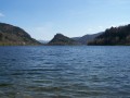
Le Grand Ventron as seen from Lake Kruth

Le Grand Ventron is a must-see peak in the Thur Valley. At 1,204 metres, it is the highest peak in the massif of the same name. It can be reached directly by car, or on foot from Lake Kruth. The walk takes you along the lake’s shores, then past the Bockloch Waterfall on the way there, and on the return journey via the Felzach Farm Inn, the village of Frenz and Wildenstein Castle. There are numerous views along the route, overlooking the highest peaks of the Vosges.

Details

n°57479089
Creation:
Last update:
Last review:
  • Walking
    Activity: Walking
  • ↔
    Distance: 13.17 mi
  • ◔
    Average duration: 8h 50 
  • ▲
    Difficulty: Very difficult

  • ⚐
    Back to start: Yes
  • ↗
    Ascent: + 3,186 ft
  • ↘
    Descent: - 3,186 ft

  • ▲
    Highest point: 3,950 ft
  • ▼
    Lowest point: 1,716 ft

Description of the walk

Park in the car park at Lake Kruth.

No signposting

(S/E) From the car park, head up the road alongside the cycle path. When you reach the lake, continue to the right along its shore. Carry on straight ahead until you reach a small road.

(1) Follow it to the left, take a bend, and continue to the start of the path to the Bocklosh Waterfall.

Blue Cross signposting

Follow the path to the right and you’ll soon reach the waterfall.

(2) Carry on along the path. At the track, turn left, then rejoin the path on the right. Some sections are steep, and the path is occasionally rocky. It climbs steadily in switchbacks, some tighter than others, alongside the stream. When you reach the next track, turn left, then right to continue climbing in switchbacks until you reach the following track.

(3) Follow this track uphill and ignore a Blue Triangle path coming from the right.

Blue Triangle signposting

Stay on the track until you reach the Cabane du Bockloch.

(4) Follow the stony track that starts to the left of the hut.

Red Triangle markings

At the Col de l’Adamskopf, continue to the right until the end of the track.

Blue Rectangle Markings

(5) Carry on along the path furthest to the left and follow it to the Grand Ventron and its orientation table.

(6) Head left towards the Petit Ventron. After a short descent, stay on the ridge and go round the Petit Ventron.

(7) Keep to the right at the junction for a short, winding descent. Then climb back up the opposite side on the same path to pass the Tête du Chat Sauvage. Descend again to reach the Chaume des Vintergés hut.

(8) Continue to the right towards the Haut de Felzach, then ignore a descending path on the left. After a winding ascent, reach the summit for a panoramic view.

(9) Descend, following the path, to the access road leading to the Ferme-Auberge de Felzach.

Blue Triangle signposting

Carry on to the right until you reach the farm.

(10) Walk past the farm and follow the track on the right. Once you’ve reached the other side of the mountain, turn onto the first Blue Triangle path on the left to cross a stream. When you reach the track, continue straight ahead, ignoring the road branching off to the right. At the junction, turn left and head for the central crossroads at Frenz.

(11) Follow the road to the left, then turn right twice. At the end, ignore a path on the right, then carry on straight ahead along the track until you reach a junction.

Blue Disc signposting

(12) Go straight on to the next junction, then carry on along the track opposite, slightly to the right.

No markings

Keep to the right until you reach a very steep descent.

Blue Disc signposting

Head down to the right, take a wide left-hand bend, then reach a road at Bourbach.

(13) Carry on straight ahead, then turn right.

Red Triangle signposting

At the junction, turn left onto the road leading to the dam.

No signposting

(14) Cross the dam, then head left along the lake to the nature trail.

Nature trail

Head up the trail to the right; after several hairpin bends, you’ll reach the ruins of Wildenstein Castle and enjoy one last view.

(15) Do take your time to explore the ruins. After passing through an underpass, follow the path on the left (you can also take the one on the right). At the next junction, head downhill, pass the treetop adventure park and, once you reach the road, turn right towards the leisure centre. Then turn right to return to the starting point. (S/E)

Waypoints

  1. S/E : mi 0 - alt. 1,765 ft - Kruth Lake car park
  2. 1 : mi 1.08 - alt. 1,811 ft - Route
  3. 2 : mi 1.35 - alt. 1,844 ft - Cascade du Bockloch
  4. 3 : mi 2.38 - alt. 2,703 ft - Trail
  5. 4 : mi 2.81 - alt. 2,943 ft - Bockloch mountain hut
  6. 5 : mi 3.63 - alt. 3,343 ft - End of the trail
  7. 6 : mi 4.69 - alt. 3,950 ft - Grand Ventron
  8. 7 : mi 5.45 - alt. 3,714 ft - Petit Ventron junction
  9. 8 : mi 6.87 - alt. 3,442 ft - Chaume des Vintergés mountain hut
  10. 9 : mi 7.77 - alt. 3,812 ft - The top of Felzach
  11. 10 : mi 8.21 - alt. 3,497 ft - Felzach Farm Inn
  12. 11 : mi 9.67 - alt. 2,559 ft - Frenz
  13. 12 : mi 10.03 - alt. 2,418 ft - Junction
  14. 13 : mi 11.17 - alt. 1,742 ft - Bourbach
  15. 14 : mi 11.55 - alt. 1,801 ft - The dam at - Lac de Kruth-Wildenstein
  16. 15 : mi 12.47 - alt. 2,175 ft - Château de Wildenstein
  17. S/E : mi 13.17 - alt. 1,765 ft - Kruth Lake car park

Notes

Shelters available at (4) and (8)
Food available at the Felzach Farm Inn.

This route passes through a protected area, which may be subject to special regulations:

Worth a visit

- (14) Lake Kruth and its dam.
- (2) Bockloch Waterfalls.
- (6) Grand Ventron and its panoramic views.
- (9) Upper Felzach and its panoramic views.
- (11) The village of Frenz.
-(15) The ruins of Wildenstein Castle and the viewpoint.

Reviews and comments

4.7 / 5
Based on 1 review

Reliability of the description
5 / 5
Ease of following the route
4 / 5
Route interest
5 / 5
Olivier Millot
Olivier Millot
• Edited:

Overall rating : 4.7 / 5

Date of your route : May 07, 2025
Reliability of the description : ★★★★★ Very good
Ease of following the route : ★★★★☆ Good
Route interest : ★★★★★ Very good
Very busy route : Yes

Hello,
Great hike
Although the directions are a bit off. I completed this hike: a distance of 25.74 km instead of 21.2 km. In terms of elevation gain, 1,096 m uphill and 1,198 m downhill, and it took 7 hours 22 minutes.

Machine-translated

Nature57
Nature57
• Edited:

Overall rating: 4.3 / 5

Date of the walk: Friday 23 August 2024
Accuracy of the description: ★★★★★ Very good
Ease of following the route: ★★★★☆ Good
Interest of the walking route: ★★★★☆ Good
Busy route: No A beautiful, long walk starting from Lake Kruth. The climb up to Grand Ventron from the lake, following the stream, is sometimes challenging, but the scenery once you reach the summit is superb, as are the panoramic views between Petit Ventron and the Ferme Auberge de Felzach. The signposting is very good throughout the route.
The directions are generally easy to follow. Only the very steep descent from the village of Frenz down to the lake struck me as really difficult. The end of the walk, with the climb and the chance to explore the ruins of Wildenstein Castle, is also very interesting. Thanks to the author for this lovely day’s walk.

Machine-translated

Other walks in the area

For more walks, use our search engine .

The GPS track and description are the property of this route's author. Please do not copy them without permission.