Neuweiher and Perches lakes via the Tête des Charbonniers

This is a very rich hike in terms of the diversity of its route, relief and views, types of paths, undergrowth and stubble biotopes, and beech forests. Not to mention the magical Lac des Perches seen from below...

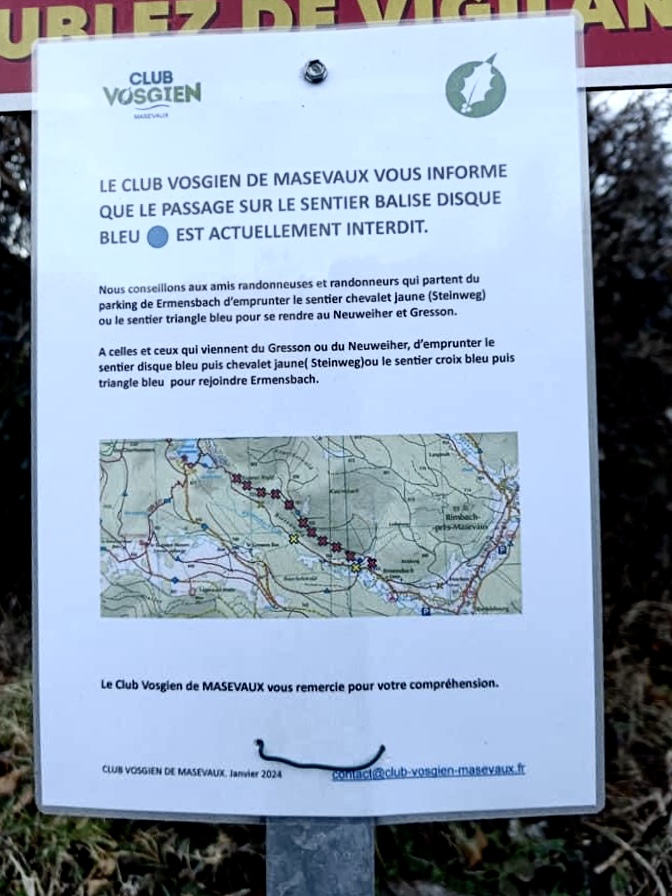
Moderator's note: the Blue Disc marked trail between (1) and its junction with the Yellow Chevalet (Steinweg) trail is closed to the public and should not be used as an alternative to the Yellow Chevalet trail.
Route modified on 26/06/2023 at point (4) to pass through theGR® 5 and join (6) due to dangerous forest decline for hikers and to preserve biodiversity.

Details

1422251
Creation:
Last update:
Last review:
  • Walking
    Activity: Walking
  • ↔
    Distance: 16.22 km
  • ◔
    Average duration: 6h 45 
  • ▲
    Difficulty: Difficult

  • ⚐
    Back to start: Yes
  • ↗
    Ascent: + 740 m
  • ↘
    Descent: - 730 m

  • ▲
    Highest point: 1,148 m
  • ▼
    Lowest point: 536 m

Description of the walk

From the D466 in Oberbruck (Masevaux valley), take the D14b towards Rimbach, then, at the entrance to Rimbach, turn left onto Rue d'Ermensbach and continue for about 300 metres.

(S/E) From the mandatory car park on the left side of the road, walk up through the village of Ermensbach. After the chapel, the road meets the yellow signpost.

(1) At the crossroads, leave the blue disc trail on your right and climb up following the yellow signposts.
After 2 km, just before Lake Petit Neuweiher, you will find the blue disc trail. Follow it to the left.

(2) Go around the Neuweiher lakes on the left. Leave the blue disc path for theGR®531marked with a blue rectangle on the left towards Gresson Moyen until you reach the Gresson farmhouse inn.

(3) At the Gresson Moyen farm, after a short break if you wish, as you will have completed most of the climb, follow the blue rectangle again for a few hundred metres to the right.

(4) Leave the blue rectangle and follow the blue cross markings towards La Roche de l'Enfer to rejoin theGR®5.

(5) Turn sharply right and follow theGR®5trail up to the Col des Charbonniers pass.

(6) When you reach Col des Charbonniers, turn right towards "Tête des Perches" on theGR®5(red rectangle). A magnificent path through the undergrowth leads to a clearing of stubble near the Haute Bers chalet.

(7) Fork in the path allowing you to return to the starting point if necessary, avoiding the passage through Les Perches (short variant in Practical Information).

(8) Continue along theGR®5on a more technical path, which remains fairly easy, to the Col des Perches.

(9) Col des Perches: view of Rouge Gazon on your left. Turn right towards Lac des Perches, taking theGR®531(blue rectangle) on a steep descent.

(10) Go around Lac des Perches on the left. Continue following the blue rectangle markers in the direction of Lac de Neuweiher. Go around Lac du Grand Neuweiher on the left. Return to the intersection you passed on the way there.

(2) Turn right for a well-deserved break at the Refuge du Neuweiher.

(11) Return to the intersection.

(2) Then return easily to the car park (S/E) by following the same route as on the way there, via the blue disc trail and then the yellow trail taken on the way to Ermensbach, then crossing the village.

You can choose to stay on the blue disc path, which runs parallel, if you do not want to take the same route as on the way there.

Waypoints

  1. S/E : km 0 - alt. 536 m - Ermensbach car park
  2. 1 : km 0.76 - alt. 564 m - Ermensbach exit via Chevalet Jaune
  3. 2 : km 3.06 - alt. 821 m - and Petit Neuweiher lake. - Lac du Grand Neuweiher
  4. 3 : km 4.23 - alt. 938 m - Ferme-Auberge du Gresson
  5. 4 : km 4.55 - alt. 969 m - Crossroads at Gresson Haut
  6. 5 : km 5.92 - alt. 1,057 m - Crossroads with the GR5
  7. 6 : km 6.47 - alt. 1,097 m - Col des Charbonniers (1115m)
  8. 7 : km 8.67 - alt. 1,120 m - Chalet de Haute Bers
  9. 8 : km 8.77 - alt. 1,126 m - Chaumes - Haute Bers
  10. 9 : km 9.84 - alt. 1,071 m - Crossroads - Col des Perches
  11. 10 : km 10.2 - alt. 985 m - Lac des Perches
  12. 11 : km 13.02 - alt. 827 m - Refuge du Neuweiher
  13. S/E : km 16.21 - alt. 537 m - Ermensbach car park

Notes

(7). A pleasant spot for a picnic.

Shortcut: Take the blue rectangle with a white stripe trail on the right, which joins theGR®531(blue rectangle) trail, which leads to the Neuweiher Lakes on the right.

The inns along the route have lovely terraces and the staff are very welcoming. This can also be useful in case of bad weather. Note that near the point (9), the Rouge-Gazon inn is just a stone's throw away if needed.

After the Gresson farm, I should point out to those who are afraid of cattle that there is a pasture to cross, but the cows are very, very peaceful.

Worth a visit

The two lakes are magnificent and can be seen from several angles. The presence of the Gresson inn means that you could consider doing this hike over two days if the 5½ to 6½ hour duration is a deterrent.

 Always be cautious and plan ahead when you're outdoors. Visorando and the author of this route cannot be held responsible for any accidents occurring on this route.

The GR® and PR® markings are the intellectual property of the Fédération Française de Randonnée Pédestre.

Reviews and comments

4.9 / 5
Based on 9 reviews

Reliability of the description
4.8 / 5
Ease of following the route
4.9 / 5
Route interest
4.9 / 5
Claudine Brom
Claudine Brom

Overall rating : 4.3 / 5

Date of your route : Jun 25, 2025
Reliability of the description : ★★★★☆ Good
Ease of following the route : ★★★★☆ Good
Route interest : ★★★★★ Very good
Very busy route : No

Just one small issue with the signage at the Gresson Moyen farmhouse inn. It is recommended to take a break there, but it didn't fit in with our schedule, so we decided to continue. However, a sign at the entrance to the farmhouse terrace explicitly prohibits access to hikers. So we took a small unmarked path through the pastures below the farm: given the nature of the route we took (muddy puddles and fences), I doubt it was the right choice, even though we managed to get back onto the signposted path. We probably should have ignored the no entry sign: other hikers may be able to confirm whether it is possible to cross the farmhouse or whether it has indeed become impossible, and may have found a "proper" way to get around the farm and rejoin the route. ... and if so, they can have the route changed on Visorando!

Machine-translated

Goldenbar3
Goldenbar3
• Edited:

Overall rating : 5 / 5

Date of your route : Aug 10, 2021
Reliability of the description : ★★★★★ Very good
Ease of following the route : ★★★★★ Very good
Route interest : ★★★★★ Very good
Very busy route : No

We completed the first part of the route (up to the Col des Perches) by following the route indicated.
As Marie90-4 said, the path between Gresson Haut and Col des Charbonniers (blue triangles) is closed due to fallen trees (fir and spruce trees are suffering from global warming and disease).
The alternative route (clearly marked on signs by the Club Vosgien) is the blue cross trail that joins the GR5.
When you reach the GR5, there is a beautiful viewpoint called "La Roche de l'Enfer" (a short detour via the path marked with a white and red rectangle). Be warned, it's a steep climb, but there are magnificent views of Lake Alfeld and the Langenberg (Ballon trail).

After more difficulties on the GR5, you will reach the Col des Perches.
Note that the "difficult passages" in the Lac des Perches cirque are secured by plastic handrails (well done again to the Club Vosgien).

At the Col des Perches, we wanted to reach the summit of the Tête des Perches as specified by momo25, but we must have missed the path and ended up at the Rouge Gazon (blue rectangle path).
We climbed to the summit of Tête des Perches via the white and blue rectangle path (at the start up to the edge of the stubble) then turned left, following the edge of the woods to reach the summit: Table + splendid view!
Note: there is another small path (50 metres before the summit on the right) that leads to a rock with a viewpoint, but the view from the table at the summit is almost prettier because it is more open.

To finish the tour (and being a little tired), we descended via the white and blue rectangular path that leads directly to Haute Bers, crosses it and joins the GR531 at the end of the stubble field.
The GR531 switchbacks are well marked, but the descent is long.

To finish, and after a beer at the Neuweiher inn, we returned to the Rimbach car park, not via the yellow sign as on the way up, but via the blue circle option: a pleasant path that crosses several fir forests and arrives lower down in the village.

Total (Decathlon GPS watch): 20.8 km and 898 m elevation gain.

Machine-translated

Marie90-4
Marie90-4

Overall rating : 5 / 5

Date of your route : Jul 25, 2021
Reliability of the description : ★★★★★ Very good
Ease of following the route : ★★★★★ Very good
Route interest : ★★★★★ Very good
Very busy route : No

Superb hike. Concerns between point 4 Gresson haut and 5 Col des charbonniers. The path is closed due to forest safety issues. Alternative route clearly marked with blue crosses. Beautiful views. Few people on the paths, you have to be brave... They take other, busier paths.

Machine-translated

marcellarcher
marcellarcher

Overall rating : 5 / 5

Date of your route : Sep 14, 2020
Reliability of the description : ★★★★★ Very good
Ease of following the route : ★★★★★ Very good
Route interest : ★★★★★ Very good
Very busy route : No

Description consistent with the reality on the ground. Perfect.

Machine-translated

lemomo25
lemomo25

Overall rating : 5 / 5

Date of your route : Jun 20, 2020
Reliability of the description : ★★★★★ Very good
Ease of following the route : ★★★★★ Very good
Route interest : ★★★★★ Very good
Very busy route : Yes

A very beautiful walk combining woodland, meadows and mountain lakes. Well-marked route with clear signage... Thanks to naturo68. Note that once we reached the Col des Perches, we continued climbing (near the top of the cable car and on the right) to reach a viewpoint overlooking Lake Perches and the entire Rimbach Valley, where there is a bench and table to enjoy this magnificent view.

Machine-translated

Janilein
Janilein

Overall rating : 4.7 / 5

Date of your route : Jun 14, 2020
Reliability of the description : ★★★★★ Very good
Ease of following the route : ★★★★★ Very good
Route interest : ★★★★☆ Good
Very busy route : No

Just great!!! Thank you, Visiorando team.

Machine-translated

cris90
cris90

Overall rating : 4.7 / 5

Date of your route : Jun 17, 2019
Reliability of the description : ★★★★☆ Good
Ease of following the route : ★★★★★ Very good
Route interest : ★★★★★ Very good

Hello,

Very good website, easy to use with different search criteria.
One area for improvement could be the written description of the route,
which sometimes lacks detail and cannot be used on its own.

Thank you, and keep up the good work!

Machine-translated

naturo68
naturo68

Just a little more rain and we can bring back our evening meal during our walk...

Machine-translated

naturo68
naturo68

Thanks for the comment. Returning via Gresson also avoids having to retrace your steps back to Neuweiher/the car park. You could also do this walk in the opposite direction without coming back down via Neuhweiler... Worth trying!

Machine-translated

CHOQUET
CHOQUET

Overall rating : 5 / 5

Date of your route : Sep 15, 2018
Reliability of the description : ★★★★★ Very good
Ease of following the route : ★★★★★ Very good
Route interest : ★★★★★ Very good

A superb hike in glorious weather, with beautiful views of the lakes.
The added bonus before heading back down, depending on the time, is to go back up to Le Gresson for a bite to eat and take the blue triangle trail for the return journey (with a little nap on the stubble fields...).

Machine-translated

valnat68
valnat68

Overall rating : 5 / 5

Date of your route : Sep 10, 2018
Reliability of the description : ★★★★★ Very good
Ease of following the route : ★★★★★ Very good
Route interest : ★★★★★ Very good

A very beautiful hike! Diverse trails and viewpoints.

Mushroom lovers, keep your eyes peeled!

Machine-translated

Other walks in the area

For more walks, use our search engine .

The GPS track and description are the property of this route's author. Please do not copy them without permission.