Circuit of the Perches, Grand and Petit Neuweiher lakes

This short hike offers breathtaking views of the Col des Perches and the lake of the same name, Sternsee. A bench and a small table above the scree overlooking the lake are ideal for a snack break while admiring the landscape.
At the Grand Neuweiher lake, stop at the refuge inn to quench your thirst before heading back to Rimbach.
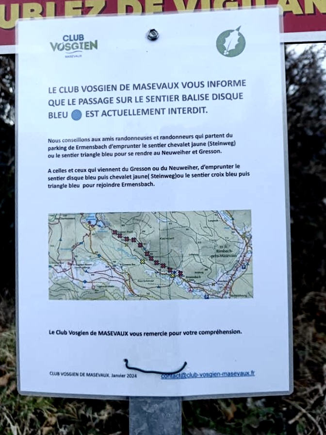
Moderator's note: the Blue Disc trail between (6) and Ermensbach is closed to the public and should not be used as an alternative to the Yellow Horse trail (Steinweg).

Technical sheet

76557
Creation:
Last update:
Last review:
  • Walking
    Activity: Walking
  • ↔
    Distance: 11.75 km
  • ◔
    Average duration: 5h 10 
  • ▲
    Difficulty: Moderate

  • ⚐
    Return to departure point: Yes
  • ↗
    Vertical gain: + 628 m
  • ↘
    Vertical drop: - 627 m

  • ▲
    Highest point: 1,137 m
  • ▼
    Lowest point: 557 m

Photos

Description of the walk

(S/E) Start from the free car park opposite the church in Rimbach near Masevaux.
Take the path opposite the car park behind the cemetery.

(1) After about 150 metres, at the intersection, take the small path on the right which leads to Rue du Belacker. Continue along this street, then Rue du Sternsee until you reach an intersection. At this point, the route has been changed. Turn left and follow the blue triangle signs towards Lac des Perches via Riesenwald.

(2) At Lac des Perches, take the path on the right marked with a blue rectangle to Col des Perches.

(3) At Col des Perches, take the path on the left towards Neuweiher, marked with redGR®5signs via Obere Bers.

(4) At Haute Bers, take the small path on the left towards the spring, marked "Blue, White, Blue".
After the spring, either continue straight ahead across the meadow or go to the chalet for a short break, then take the path opposite the chalet marked "Blue, White, Blue Rectangle" to the forest entrance.
The markings change. Continue straight ahead along the path via Joppelberg, following the blueGR®531rectangle markings. See Practical Information.

(5) When you reach the lake, stop for a break at the Auberge-Refuge du Neuweiher before heading back towards Ermensbach (blue disc).

(6) At the intersection, follow the "Chevalet Jaune" signs along the stone path towards Ermensbach. You will arrive at Rue de la Mine, then Rue d'Ermensbach at the chapel.

(7) At the Ermensbach chapel, turn left, then 50 metres further on, turn right towards Rimbach, following the "Croix Jaune" signs to the cemetery of the Rimbach church. Opposite is the car park where the route starts (S/E).

Waypoints

  1. S/E : km 0 - alt. 559 m - Free parking opposite the church in Rimbach.
  2. 1 : km 0.09 - alt. 578 m - Fork in the road, turn right.
  3. 2 : km 4.08 - alt. 980 m - Lac des Perches
  4. 3 : km 4.49 - alt. 1,070 m - Col des Perches
  5. 4 : km 5.57 - alt. 1,128 m - Turn left before the > - Chalet de Haute Bers
  6. 5 : km 7.64 - alt. 827 m - Lac du Grand Neuweiher
  7. 6 : km 8.33 - alt. 779 m - Fork in the road, turn right.
  8. 7 : km 10.28 - alt. 559 m - Turn left at the chapel.
  9. S/E : km 11.75 - alt. 558 m - Free parking opposite the church in Rimbach.

 Always stay careful and alert while following a route. Visorando and the author of this walk cannot be held responsible in the event of an accident during this route.

The GR® and PR® markings are the intellectual property of the Fédération Française de Randonnée Pédestre.

Reviews and comments

4.8 / 5
Based on 75 reviews

Reliability of the description
4.7 / 5
Clarity of route map
4.8 / 5
Route interest
4.8 / 5
User 25941137

Overall rating : 5 / 5

Date of walk : Jun 01, 2025
Reliability of the description : ★★★★★ Very good
Clarity of route map : ★★★★★ Very good
Route interest : ★★★★★ Very good
Busy trail : Yes

A wonderful tour with my 78-year-old mum, who walks every day but doesn't hike.

Automatically translated

Clemss
Clemss

Overall rating : 4.7 / 5

Date of walk : Apr 13, 2025
Reliability of the description : ★★★★★ Very good
Clarity of route map : ★★★★★ Very good
Route interest : ★★★★☆ Good
Busy trail : No

Top application, very accurate route description and tracking, easy to use. Nice route with beautiful views of the Lac des Perches.

Automatically translated

Ninne
Ninne

Overall rating : 3.7 / 5

Date of walk : Feb 20, 2025
Reliability of the description : ★★★★☆ Good
Clarity of route map : ★★★☆☆ Average
Route interest : ★★★★☆ Good
Busy trail : Yes

Lovely walk, interesting viewpoints The markings are sometimes difficult to see.

Automatically translated

Alsacenath
Alsacenath

Overall rating : 5 / 5

Date of walk : Nov 08, 2024
Reliability of the description : N/A
Clarity of route map : N/A
Route interest : ★★★★★ Very good
Busy trail : No

Superb walk in autumn colours and beautiful sunshine, the lakes were magnificent!
There were plenty of places to picnic or eat at the Neuweiher inn, which we recommend. It took us 3 hours to get there from the start.

Automatically translated

sandrine.martin
sandrine.martin

Overall rating : 5 / 5

Date of walk : Oct 23, 2024
Reliability of the description : ★★★★★ Very good
Clarity of route map : ★★★★★ Very good
Route interest : ★★★★★ Very good
Busy trail : Yes

beautiful route, tough climb but magnificent view, in autumn this lake and its reflections is truly majestic.

Automatically translated

Catherine Catouche
Catherine Catouche
• Last modified:

Overall rating : 5 / 5

Date of walk : Aug 10, 2024
Reliability of the description : ★★★★★ Very good
Clarity of route map : ★★★★★ Very good
Route interest : ★★★★★ Very good
Busy trail : Yes

We did this walk on a Sunday in very hot weather.
The first half of the hike is difficult because of the steep gradient.
Fortunately, there are some great rewards in the form of magnificent scenery.
On the descent to Lake Neuweilher, we were treated to a concert all the way from the auberge!
We had a picnic by the lake and came back down, happy to have reached the car.

Automatically translated

Positiver68
Positiver68

Overall rating : 5 / 5

Date of walk : Jul 27, 2024
Reliability of the description : ★★★★★ Very good
Clarity of route map : ★★★★★ Very good
Route interest : ★★★★★ Very good
Busy trail : No

A hike that I do once or twice a year.
2 magnificent lakes; the Haut Bers hut is a marvel with a lovely picnic table and blueberries all around.

Automatically translated

JOSETTE25
JOSETTE25

Overall rating : 5 / 5

Date of walk : Jul 24, 2024
Reliability of the description : ★★★★★ Very good
Clarity of route map : ★★★★★ Very good
Route interest : ★★★★★ Very good
Busy trail : No

Superb parking at the start. Super rondo with three superb lakes. Quite a steep climb to the Col des Perches. Then a stony path to the other two lakes, but without difficulty. This hike is often in the forest, so is very enjoyable in very hot weather.

Automatically translated

tutublod
tutublod

Overall rating : 5 / 5

Date of walk : May 29, 2024
Reliability of the description : N/A
Clarity of route map : ★★★★★ Very good
Route interest : ★★★★★ Very good
Busy trail : No

The climb up to the Lac des Perches is very interesting, with beautiful paths and scenery.
When we reached the lake, we took the GR 531 (blue rectangle), which passes beneath the lake. It's a fine path, but quite rocky and technical, especially in wet weather.
For a snack, we took advantage of the "hors sac" shelter near the Auberge du Neuweiher.
The return journey to Rimbach took us along the aptly-named "Steinweg" (stone path), signposted in yellow, as the beautiful blue-disc path had unfortunately been condemned by the owner.

Automatically translated

Simdel
Simdel

Overall rating : 4.7 / 5

Date of walk : May 11, 2024
Reliability of the description : ★★★★★ Very good
Clarity of route map : ★★★★☆ Good
Route interest : ★★★★★ Very good
Busy trail : Yes

Hello,
A very nice hike with a fairly steep start. Access to the Lac des Perches and then the Col des Perches provides a pleasant downhill route, albeit rocky on some sections. Beautiful scenery and pleasant shade in warm weather. The lakes also provide an opportunity to cool off. Many springs dot the route.
A few signposting problems at the end due to a dispute with forest owners, but nothing too serious as parallel access is possible.
The car park provided by the local council at the start is really very good, thank you.
I would recommend

Automatically translated

T0urmaline
T0urmaline

Overall rating : 4.7 / 5

Date of walk : Apr 28, 2024
Reliability of the description : ★★★★★ Very good
Clarity of route map : ★★★★★ Very good
Route interest : ★★★★☆ Good
Busy trail : No

Taken on 27 April 2024, we thoroughly enjoyed this hike. The first part up to Lac des Perches is quite strenuous, and the section leading up to the Col des Perches is even more so! (We're in our sixties).
The stone path on the way back is a curiosity.

Automatically translated

Jewa
Jewa

Overall rating : 4.7 / 5

Date of walk : Apr 14, 2024
Reliability of the description : ★★★★★ Very good
Clarity of route map : ★★★★★ Very good
Route interest : ★★★★☆ Good
Busy trail : No

Lovely walk, very fine viewpoint at the tête des perches
Alternating dirt and stone paths
relatively technical descent at times

Automatically translated

bourdenetpierrot
bourdenetpierrot

Overall rating : 3.7 / 5

Date of walk : Apr 06, 2024
Reliability of the description : ★★★★☆ Good
Clarity of route map : ★★★★☆ Good
Route interest : ★★★☆☆ Average
Busy trail : Yes

The climb up to the Lac des Perches is a very sad one along a forestry track that reveals a very sick forest with a lot of clear-cutting by foresters who leave a lot of branches on the spot - it looks like a war zone.
The section between Lac des Perches and Lac de Neuweiher is very beautiful, with lovely paths and a superb view.
The return from point 6 is really not so good with an unpleasant and compulsory stone path, the blue disc path being forbidden following the purchase by a landowner who closed the passageway
If this continues, we'll soon be hiking on tarmac roads.

Automatically translated

Alexi90
Alexi90
• Last modified:

Overall rating : 5 / 5

Date of walk : Oct 06, 2023
Reliability of the description : ★★★★★ Very good
Clarity of route map : ★★★★★ Very good
Route interest : ★★★★★ Very good
Busy trail : Yes

Super hike

Automatically translated

marmotton
marmotton

Overall rating : 4.3 / 5

Date of walk : Sep 06, 2023
Reliability of the description : ★★★★☆ Good
Clarity of route map : ★★★★☆ Good
Route interest : ★★★★★ Very good
Busy trail : Yes

Very nice walk in very good weather with shady sections.
Very good description, perfect signposting, safe and tricky sections. Well done to the signposters.
There was just one problem with the Neuweiher refuge: we booked in the morning and when we arrived there was no table reserved and no hot meal. After a three-quarter wait we were served two frugal planks at a very high price... not a nice welcome and no apologies. Absolutely not!

Automatically translated

Other walks in the area

For more walks, use our search engine .

The GPS track and description are the property of the author. Do not copy them without permission.