Country:

 City:


The walk is accessible by free bus (departure and arrival): the starting point for the walk is at the ‘Les Alliés’ stop on bus route 7 (Aubagne Station – Gémenos).
By car, there are two car parks nearby on Boulevard Vessiot.
(S) Walk up Boulevard des Alliés heading west. At the junction, turn left. You’ll come to a roundabout. On the left are the war memorial and the town hall square. Opposite, slightly to the left, take Boulevard Vessiot.
At the end of the boulevard, turn right onto Rue Sébastien Maurice Lambert, then left just before the cemetery onto Chemin Paul Borgiali. The track winds its way uphill alongside the cemetery. Pass Avenue de la1re Division Française Libre on your left. Further up, turn right onto the Corniche du Douard. Further on, turn slightly right onto Chemin du Cruvelier. At the end of the path, where there is a car park, carry on straight ahead along the dirt track towards Le Cruvelier / Col de l’Ange.
Further on, go through the barrier. Marker SB105. Carry on straight ahead. At marker SB106, leave the path on your right. Yellow and yellow-red markings. Stay on the track (passing a Yellow Cross) until you reach a Fork in the road.
(1) Here, turn left onto the track leading downhill. Pine forest. There are small paths branching off to the right and left. Stay on the track.
At a crossroads, carry straight on along the track that descends, leaving a track that climbs to the right. The descent is steep and strewn with stones. Take care. At the bottom of the descent, there is a crossroads. Head straight ahead, veering slightly to the left, towards ‘Accès Domaine de Saint-Pons’. A little further on, follow the signs for ‘Le Paradou’ to reach this spot.
(2) Walk through the restored ruins of this former paper mill. The site’s history is explained on information boards. On leaving Le Paradou, turn right towards Abbaye de Saint-Pons. Walk alongside the River Fauge and you will soon reach the Ancien Moulin du Foulon with its small waterfall on the right.
(3) Continue towards Saint-Pons Abbey. You’ll come to asecond mill, known as the Moulin de Cuges, which is more imposing.
(4) From here, take a circular detour to visit the abbey and the spring. Take the steps on the right towards the Sentier de Cabrelles / Sentier du Blé. However, do not follow these paths to the right. Carry on straight ahead, walking alongside the waterfall on a wooden walkway and passing under a small porch. Cross through a woodland and emerge into a large clearing. Continue through this clearing until you reach the Source de Saint Pons. Cross the bridge and head back down the path which rejoins the abbey and runs alongside its north side. There is a large clearing on the right.
(5) Opposite the abbey entrance (west façade), there is a small flight of steps leading down, marked in yellow and red; this is theGRP® Marseille 2013. Take this path (towards Vallon du Fauge / Moulin de Cuges) and follow the stream. After a beautiful waterfall on the left, take the small bridge on the left. Head to the junction of this circular loop.
(4) Take the small flight of steps again towards the Sentier des Cabrelles / Sentier du Blé. Then turn immediately right, and right again, joining the Sentier du Blé. Yellow markings. Climb the winding path to reach a power line pylon.
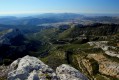
(6) Carry on straight ahead and enjoy the beautiful panoramic view down over the Saint-Pons valley.
Further on, go through the gate. Immediately afterwards, take the track on the right towards Gémenos via Cruvelier. At the bend to the right, take the path climbing up to the left, marked in red and yellow. You’ll reach the Jas du Brigou.
(7) Set off again from the Jas du Brigou heading south-east, following the yellow and red/yellow markings. There is a wire fence on the left. Further on, the yellow and red/yellow markings branch off to the right; do not follow them, but turn left instead. Stay on the main path, cross theGR®98and head straight ahead onto a wide track below the path. Pass under a high-voltage power line. Opposite lies the Pic de Bertagne with its radome, which looks like a golf ball. Reach another junction at marker SB108.
(8) Turn right at the next hairpin bend; at the next right-hand bend, stay on the track and follow a path at marker SB203.
(9) Take this path to the left, then veer left at a hairpin bend. You will then reach another track. Take this one to the right this time. Continue along the path that follows it. Pass under the high-voltage power line again. You will come to a wider track and then a four-way junction at a place called La Pugeade.
(10) Turn 180° to the left, then take a right-hand hairpin bend onto the Chemin des Favelouns. Follow this track downhill to the junction with the Traverse de Puyricard.
(11) Turn right here and continue down the hill to reach the ‘Le Puits’ bus stop (S/E) on route 11 (Aubagne Station – Cuges-les-Pins).
If travelling by car, there is a small car park next to the bus stop.

 Visorando Member

 Difficult

 Association / Club / Walk leader