Country:
 City:
City:


Park in the car park on Calle de Jaen. However, on market days or during the high season, it can be difficult to find a space there.
(S/E) Walk down to the promenade along the beach (Playa de Levante) and follow it to the left.
(1) Almost at the end, turn into the street on the left and carry on, always following the signs for “Torre de les Caletes”. You can’t go wrong, but you’ll always be on a tarmac road. Enjoy the lovely views of the sea and the various coves.
(2) You’ll come to some steps – climb them.
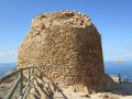
(3) You’ll arrive at the foot of the tower. There are information boards explaining the tower’s history. It forms part of a network of watchtowers built in the 16th century along the coast to defend against pirate raids. These towers communicated with one another using fires and/or smoke signals.
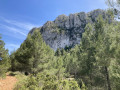
Take in the scenery, both of the mountains (the Serra Gelada) and the sea, with the island of Benidorm clearly visible.
(4) Leave the tarmac road and take the fairly wide stony path on the left, which descends towards the sea. When you’re almost at the bottom, turn left to follow the narrower path, which is somewhat hidden by the vegetation but still clearly visible. To go round the cliffs, it’s best to climb up a little.
(5) Cross the Barranco de Pico (the bed of a small river) via a fairly wide concrete bridge, taking care, and continue along the path ahead.
(6) You’ll reach a tarmac road situated at a lower level than the one you took on the way there; continue along this road. Pass a junction where one road leads down to the cove (Cala del Tio Xima) and carry on along the path.
(7) You’ll reach a clearly visible spot bearing the name ‘Benidorm’ in large letters, with the Spanish flag fluttering in the wind (this is an easily recognisable landmark). Head down a little to the left and take a path that branches off to the left.
(8) Climb onto a wide concrete culvert and follow it by walking along it: the culvert is flat and poses no risk.
(9) When you reach the end of the pipe, you’ll come out onto the road you took on the way there, at a bend near a restaurant.
All that remains is to retrace your steps along the rest of the path to return to the car park. (S/E)
 Visorando Member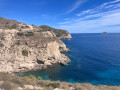
 Easy
Easy 
 Difficult