Country:

 City:
City:


Start from the car park of the community hall (2J grocery shop). Follow the orange No. 2 signs.
(S/E) With the town hall annex behind you, turn left onto the departmental road, passing in front of the church.
(1) Take the road on the right, heading down towards the dirt track below the Lodge la Fruitière, going round the old pigsty.
(2) At the junction, carry on straight along the path leading down towards the mill.
(3) At the Fork in the road, take the small dirt track on the left which leads to Rue du Bief à la Dame; cross this towards Rue du Vivi (known as ‘le Vivi’). Then continue along the main track until you reach the road.
(4) Turn left at the junction on the road to reach the Carvins oven, then turn back and take the path on the left under the trees by the beautiful house.
(5) At the end, at the junction, take the path on the right to reach the Granges du Poizat and the Barmelles oven before retracing your steps to take the “chemin des vaches” on the left, signposted by a pretty painted sign and directional signs.
(6) After passing the power lines, take the path on the left into the forest.
(7) After the descent through the forest, when you can no longer go straight on, take the path on the right.
(8) The Replat oven is ideally situated, with its adjoining fountain. Take care when using the road on the right, as there is no pavement for a few metres before rejoining the small road that descends to the left after the bend and another fountain.
(3) Carry on straight ahead at the junction you’ve already passed on the way there.
(2) Take the dirt track heading left towards the pastures.
(9) At the crossroads, turn left.
(10) After passing under the trees, take the small grassy path on the right.
(11) Turn left at the Fork in the road, then cross the stream to begin the climb.
(12) Continue to the left as you emerge from the pine forest to visit the Vierge de Lalleyriat (a round trip) and enjoy the superb view of the village.
(12) Return to the Fork in the road and turn left.
(13) At the end, take Rue de l’Ariette on the left.
(14) Turn right at the junction with the Route du Plateau to walk to the Four de la Millière (and back), passing in front of the town hall (climb the few steps; the oven is set back slightly to the right of the town hall). Then return to the junction.
(14) Carry on to the right.
(15) At the Fork in the road in front of the Carre oven, just to the left of the wash house, turn left and continue towards the forest.
(16) At the Fork in the road, turn right onto the path leading up to Le Ris.
(17) After the climb, when you reach the road, follow it, turning sharply to the right.
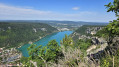
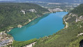
(18) At the junction, take the path on the right – the one that goes downhill and leads you to walk alongside the Lalleyriat lake, overlooking it (don’t miss the view on the right).
(19) At the fork in the road, carry on along the white track which climbs to the left.
(20) Turn right to head back down towards the village. Watch out for barbed wire and make sure you close the gates properly.
(21) Continue left onto Rue de la Traversée. Pass the last oven on the walk: the Poizat oven. You’ll need to climb a few steps to reach it, but it’s clearly visible from the road. Continue on to the car park (S/E).
 Association / Club / Walk leader
 Visorando Member
 Difficult
 Easy
Easy  Tourist office