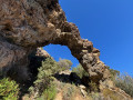
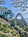
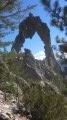
The little arch at Ficaghjola

The first part of this walk follows the Mare a Mare route, starting from Corte, near the Citadel. The path then, opened by the organisers of the “Périple de l’Arche” (Trail), climbs towards a small arch carved into a granite rock. This circular route ends by passing by the “Casetta” (little house). 

Details

n°69148225
Creation:
Last update:
Last review:
  • Walking
    Activity: Walking
  • ↔
    Distance: 3.24 mi
  • ◔
    Average duration: 2h 35 
  • ▲
    Difficulty: Moderate

  • ⚐
    Back to start: Yes
  • ↗
    Ascent: + 1,266 ft
  • ↘
    Descent: - 1,260 ft

  • ▲
    Highest point: 2,487 ft
  • ▼
    Lowest point: 1,486 ft
  • ⚐ Country: France
  • ⚐ City: Corte (20250)
  • ⚑
    Start/End: N 42.308676° / E 9.146505°
  • ❏
    IGN map(s): Ref. 4250OT, 4250OTR, 4251OT, 4251OTR
  • Hour-by-hour weather

Photos

Description of the walk

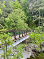
The starting point is the same as that for the walk leading to the Rossulinu footbridge, not far from the car park situated below the Citadel. The path begins at the yellow signpost indicating the Tavignanu Valley. It also points to the A Sega Refuge, which is a stop on the Mare a Mare Nord route (a 5½-hour walk).

(S/E) Follow this orange-marked path for 2.4 km, after passing through the makeshift gate a few metres from the start, until you reach the fork in the path.

(1) Leave the Mare a Mare path and head up to the right until you reach a flat area. The path is no longer marked but is clearly visible on the ground.

(2) You’ll reach a small plateau offering views towards Corte; continue to the left, towards the valley floor, until you reach a partially ruined sheepfold.

(3) Please note: the path to follow is to the left of the sheepfold. The path then climbs towards the small arch.

(4) The climb takes you to the Ficaghjola Arch. Then, follow the path to the right to reach the ridge.

(5) On the path leading to the Casetta, perched on the ridge, this stop gives you the chance to see the Citadel and Corte in the distance. Continue downhill along the faintly marked path.

(6) At the fork, keep left onto the path which generally follows the contour line and leads to the hilltop where the Casetta (small stone house) stands.

(7) Then take the path which descends back towards the starting point, skirting the ridge (S/E).

Waypoints

  1. S/E : mi 0 - alt. 1,486 ft - Sign for A Sega
  2. 1 : mi 1.49 - alt. 1,906 ft - Turn right at the fork
  3. 2 : mi 1.8 - alt. 2,152 ft - Small plateau
  4. 3 : mi 1.88 - alt. 2,080 ft - Head to the left, towards the sheepfold
  5. 4 : mi 2.09 - alt. 2,470 ft - Arcu di Ficaghjola
  6. 5 : mi 2.18 - alt. 2,415 ft - Viewpoint over Corte
  7. 6 : mi 2.24 - alt. 2,303 ft - Junction
  8. 7 : mi 2.58 - alt. 2,451 ft - A casetta
  9. S/E : mi 3.24 - alt. 1,493 ft - Sign for A Sega

Notes

The yellow sign points to A Sega (mountain hut). This is the starting point for hikes in the Tavignanu Valley. “A Sega” is one of the stages on the Mare A Mare Nord route (a 5½-hour walk). 

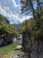
During the summer season, don’t forget to bring your swimming costume, a snack, a large bottle of water and walking poles, which will come in handy on the descent to the river.

Worth a visit

- Tavignano Gorges

Reviews and comments

3.4 / 5
Based on 3 reviews

Reliability of the description
3.7 / 5
Ease of following the route
2.7 / 5
Route interest
4 / 5
User 23121971

Overall rating : 3 / 5

Date of your route : Sep 21, 2026
Reliability of the description : ★★★☆☆ Average
Ease of following the route : ★★☆☆☆ Disappointing
Route interest : ★★★★☆ Good
Very busy route : No

The first part of the route is very well signposted, but as soon as you turn off to head back towards Corte, things get a bit tricky.
To begin with, the path you need to take on the right is hard to spot, and from there on, there are no further signposts.
According to the directions on Visorando, the path is visible, but when you reach the spot with a lovely view of Corte, you have to search to find it again. There are several buildings that could be mistaken for the sheepfold.
The climb that follows is difficult and you’ll need to use your hands to make your way up the path.
In the end, it took us over 4 hours to complete the walk instead of the 2½ hours indicated.

Machine-translated

max 05700
max 05700

Overall rating : 4 / 5

Date of your route : May 26, 2025
Reliability of the description : ★★★★☆ Good
Ease of following the route : ★★★★☆ Good
Route interest : ★★★★☆ Good
Very busy route : No

Point 5 mentions the caseta, but it is located on the ridge further on, so you still have to climb quite a bit.
But if you follow the trail on the map, you can't go wrong.

Machine-translated

DomCat
DomCat

Overall rating : 3.3 / 5

Date of your route : Apr 10, 2025
Reliability of the description : ★★★★☆ Good
Ease of following the route : ★★☆☆☆ Disappointing
Route interest : ★★★★☆ Good
Very busy route : No

The hike started off well: sunny weather with a cool breeze and a
superb scenery. Don't miss the fork at point 1, then climb up towards the arch. The climb is quite steep but pleasant as it's in the woods. Things get worse after the arch. At point 5, we couldn't find the path leading to La Casseta. After several exhausting attempts, we decided to catch up with the sheepfold at point 3 via another path. In the end, we returned by the same route, with a 5-hour hike instead of the planned 2½ hours. Could you add more details or photos, or check whether this route is still passable? I still have fond memories of the beautiful views.

Machine-translated

Other walks in the area

For more walks, use our search engine .

The GPS track and description are the property of this route's author. Please do not copy them without permission.