The Arcu di U Scandulaghju

Setting off from Corte, embark on a challenging adventure that will take you to the iconic and majestic Arcu di U Scandulaghju. This demanding hike, with its 1,060 metres of elevation gain, combines physical exertion with the discovery of an exceptional natural site.

Details

n°69895076
Creation:
Last update:
Last review:
  • Walking
    Activity: Walking
  • ↔
    Distance: 5.14 mi
  • ◔
    Average duration: 5h 30 
  • ▲
    Difficulty: Difficult

  • ⚐
    Back to start: Yes
  • ↗
    Ascent: + 3,599 ft
  • ↘
    Descent: - 3,593 ft

  • ▲
    Highest point: 4,797 ft
  • ▼
    Lowest point: 1,506 ft
  • ⚐ Country: France
  • ⚐ City: Corte (20250)
  • ⚑
    Start/End: N 42.308936° / E 9.146246°
  • ❏
    IGN map(s): Ref. 4250OT, 4250OTR, 4251OT, 4251OTR
  • Hour-by-hour weather

Photos

Description of the walk

The Citadel car parks are located very close to the start (they are pay-and-display). Head towards the terrace (viewpoint) situated at the bend. The start is on the right at the end of the cul-de-sac.

(S/E) A wooden sign marks the start, a few metres above the famous Mare a Mare hiking trail in the Tavignanu valley. The walk begins with an initial climb up the ridge to a small stone cottage called A Casetta (approximately 300m of ascent over 1 km).

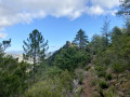
(1) At Casetta, a short break gives you the chance to enjoy a lovely view of Corte. Continue along the path to the right, crossing the hillside to begin a second climb up the path formed by a few rocky slabs. After a short flat section, pass the chestnut trees to begin the third climb, keeping to the left beneath the pine trees, towards the Col de la Croix.

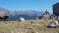
(2) Col de la Croix (1,112 m); the cross is visible on the left. A lovely view over the peaks of La Punta Latiniccia (on the left) towards Monte Rotondu. Below, the entire ridge line stretches from the Alzu plateau to the Pointe de Zurmulu. Continue along the path to the right until you reach the fourth ascent.

(3) Begin a short climb (less than 100 m), which is quite steep but not exposed to a drop-off, sometimes requiring you to use your hands to steady yourself. Once you reach the flat section, go past the rocks and continue along the path to the right until you reach the climb up to the “Bâton”.

(4) You’ll reach the foot of the fifth (steep) climb towards the “Bâton”. Reach the small pass known as “le Bâton” (at an altitude of 1,400 m).

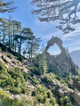
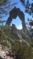
(5) The path then descends for a few metres before gradually climbing again towards the Arch. You can see the majestic arch, carved by nature into the granite, until you reach it.

(6) Continue along the path for a few metres to take some lovely photos. The return journey follows the same route as the outward journey (S/E).

Waypoints

  1. S/E : mi 0 - alt. 1,529 ft - Wooden signpost indicating the Arch
  2. 1 : mi 0.64 - alt. 2,451 ft - A casetta
  3. 2 : mi 1.49 - alt. 3,648 ft - Col de la Croix
  4. 3 : mi 1.79 - alt. 4,111 ft - 4th ascent
  5. 4 : mi 1.95 - alt. 4,426 ft - Ascent of the Bâton
  6. 5 : mi 2.01 - alt. 4,593 ft - The Walking Stick
  7. 6 : mi 2.56 - alt. 4,754 ft - the Arch
  8. S/E : mi 5.13 - alt. 1,506 ft - Wooden signpost indicating the Arch

Notes

Please note: you must follow the GPX file and not rely on the IGN maps, as their route is incorrect.

This hike is challenging. Make sure you take plenty of water, as there are no water sources along this trail. Walking poles are recommended and very useful on both the outward and return journeys. 

Worth a visit

-Arcu di u Scandulaghiu

Reviews and comments

4.3 / 5
Based on 2 reviews

Reliability of the description
5 / 5
Ease of following the route
4 / 5
Route interest
4 / 5
F8DHA
F8DHA

Overall rating : 4.3 / 5

Date of your route : Jun 08, 2026
Reliability of the description : ★★★★★ Very good
Ease of following the route : ★★★★☆ Good
Route interest : ★★★★☆ Good
Very busy route : Yes

A lovely walk, offering stunning views of the valley and the surrounding peaks. The finish is a surprise, with the arch coming into view at the very last moment. The walk is quite challenging as it’s uphill all the way to the end. At point 2, we’re in the undergrowth and in the shade, but it’s still uphill and in some places you need to use your hands to get up. It took me 3 hours to reach the arch, but I’m no spring chicken either. The path isn’t a problem; the markings have been repainted in red up to point 2, after which they remain more or less visible and end in yellow
The return journey isn’t any easier as the stones are slippery, so make sure you wear suitable footwear and take water with you.
I set off from the free car park at the station; allow an extra 15 minutes, as the car park at the start of the route is pay-and-display and often full depending on the time. There are three free spaces at the start if you arrive very early.

Machine-translated

F8DHA
F8DHA
• Edited:

Overall rating : 4.3 / 5

Date of your route : Jun 08, 2026
Reliability of the description : ★★★★★ Very good
Ease of following the route : ★★★★☆ Good
Route interest : ★★★★☆ Good
Very busy route : Yes

A lovely walk, offering stunning views of the valley and the surrounding peaks. The finish is a surprise, with the arch coming into view at the very last moment. The walk is quite challenging as it’s uphill all the way to the end. At point 2, we’re in the undergrowth and in the shade, but it’s still uphill and in some places you need to use your hands to get up. It took me 3 hours to reach the arch, but I’m not 20 anymore either. The path isn’t a problem; the markings have been repainted in red up to point 2, after which they remain more or less visible and end in yellow
The return journey isn’t any easier as the stones are slippery, so make sure you wear suitable footwear and take water with you.
I set off from the free car park at the station; allow an extra 15 minutes, as the car park at the start of the route is pay-and-display and often full depending on the time. There are three free spaces at the start if you arrive very early.

Machine-translated

Other walks in the area

For more walks, use our search engine .

The GPS track and description are the property of this route's author. Please do not copy them without permission.