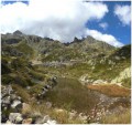
Forest and alpine pastures on the heights of Argentière

Outward journey from Argentière via Aiguillette d'Argentière and Lac Blanc, then down via Flégère to Les Praz de Chamonix.
Return to Argentière by train from Les Praz station. Otherwise two cars are required for arrival and departure.

Technical sheet

172089
Creation:
Last update:
Last review:
  • Walking
    Activity: Walking
  • ↔
    Distance: 14.36 km
  • ◔
    Average duration: 7h 20 
  • ▲
    Difficulty: Difficult

  • ⚐
    Return to departure point: No
  • ↗
    Vertical gain: + 1,138 m
  • ↘
    Vertical drop: - 1,322 m

  • ▲
    Highest point: 2,358 m
  • ▼
    Lowest point: 1,059 m

Photos

Description of the walk

Start: Access to Argentière is via the D1506 from Chamonix (9km). Park in the Argentière station car park on the right just after passing under the railroad bridge.

(S/E) From the car park, follow the main street to the right for 150m and find the Chemin des Grands Bois on the left at the Hôtel-Restaurant de la Couronne.

(1) Follow this beautiful path, keeping to the right at each junction for 1100m.

(2). Go straight ahead and climb for 650m to the crossroads.

(3) Go straight on and climb for another 600m, staying left at the next two forks. Continue up to Aiguillette d'Argentière 1895m.

(4) Continue uphill for 850m to the crossroads.

(5). Go straight on, turning left at the next intersection. Climb to the right at the fork, skirt one of the Chéserys lakes and continue to the refuge.

(6) Continue to Lac Blanc.

(7) Skirt the lake and follow the path down to a crow's-foot.

(8). Turn left and continue downhill, keeping right at every junction until you reach Lac de la Flégère 2027m.

(9) Turn left and descend to a large track.

(10). Continue on this big track, passing under the Chavanne chairlift and continuing down to a path which shortens the laces of the track.

(11) Fork right and find the end of the track, which takes you behind the Flégère cable-car station.

Turn right behind the station and, at the end of the road, you'll find a crow's-foot.

(12) Take the left-hand path and go down, first left, then right, until you reach a large track. Turn right and descend this track to the bottom of the valley.

(13). Opposite, take a large track which takes you along the Arve to a second bridge over the torrent.

(14) Before the second bridge, take a path to the right, then immediately turn left. Follow this path along the Arve until you pass under the Flégère cable car and arrive at the car park behind the cable car departure station.

(15) Cross the car park and go straight on to the route des Praz. Cross this road and continue straight ahead on Rue de la Chapelle towards the D1506 roundabout. Go around it to the right and take Rue des Gaudenays opposite.

Turn right into Impasse de la gare, and you'll reach Les Praz station after 100m (S/E).

Waypoints

  1. S : km 0 - alt. 1,244 m - Car park - Gare d'Argentière (Hte-Savoie)
  2. 1 : km 0.19 - alt. 1,252 m - Left fork onto main road
  3. 2 : km 1.27 - alt. 1,484 m - Three-way junction, turn left
  4. 3 : km 1.84 - alt. 1,617 m - Crossroads, continue straight on
  5. 4 : km 3.32 - alt. 1,907 m - Aiguillette d'Argentière
  6. 5 : km 4.12 - alt. 2,132 m - Crossroads, continue straight on
  7. 6 : km 5.72 - alt. 2,358 m - Chalet du Lac Blanc
  8. 7 : km 5.76 - alt. 2,352 m - Lac Blanc
  9. 8 : km 6.14 - alt. 2,306 m - Three-way junction, keep left
  10. 9 : km 7.65 - alt. 2,031 m - Three-way junction at Lac de la Félgère, keep left
  11. 10 : km 8.05 - alt. 1,964 m - Crossing with large track, keep left
  12. 11 : km 8.36 - alt. 1,892 m - Right fork on path
  13. 12 : km 8.85 - alt. 1,889 m - Three-way junction, take the path on the left - Refuge la Flégère (1807m)
  14. 13 : km 13.22 - alt. 1,069 m - Three-way junction on the road, go straight ahead towards the - Arve (rivière) - Affluent de l'Arve
  15. 14 : km 13.46 - alt. 1,066 m - Junction before the bridge over the Arve
  16. 15 : km 13.87 - alt. 1,061 m - Cable car departure station, car park
  17. E : km 14.36 - alt. 1,063 m - Car park - Gare de Les Praz-de-Chamonix

Practical information

Start: Access to Argentière is via the D1506 from Chamonix (9km). Park in the Argentière station car park on the right just after passing under the railroad bridge.

Transport: Return train schedule, Les Praz - Argentière :
15h58 - 16h13
4.27pm - 4.41pm
4.58pm - 5.13pm
5.57pm - 6.13pm

Transport is free for holders of the Carte d'Hôte, given to you on arrival by your accommodation provider.

Reviews and comments

4.7 / 5
Based on 1 review

Reliability of the description
5 / 5
Clarity of route map
4 / 5
Route interest
5 / 5
manuelleduc
manuelleduc

Overall rating : 4.7 / 5

Date of walk : Aug 06, 2016
Reliability of the description : ★★★★★ Very good
Clarity of route map : ★★★★☆ Good
Route interest : ★★★★★ Very good

A short walk to get you back into the swing of things before a multi-day hike in the following days.
A very pleasant itinerary, even if the end of the hike is a little spoilt by the sight of the ski lifts on the way down to Chamonix. Don't hesitate to do this hike in spite of everything, especially for those who haven't yet had the chance to see the Lac Blanc!

Automatically translated

Other walks in the area

For more walks, use our search engine .

The GPS track and description are the property of the author. Do not copy them without permission.