Country:
 City:


The starting point is at the Saint-Savournin Centre bus stop, on the north side of the road.
For cars, there is parking available after the roundabout on the road towards Gardanne.
(S) Cross the road and take the steps (the ‘traverse du lavoir’) opposite. When you reach a road, turn right. At Place Couton-Marceau, turn left uphill; this is where the yellow and red/yellow signposting begins.
Then turn right, leaving the garages on your left, and take the path to the right of the rubbish bins. There’s a lovely view of Sainte Victoire to your right. Ignore a track coming from the right and head straight up the steep slope until you reach the fork at elevation 577, by a barrier.
(1) Leave the yellow and red/yellow markings. Take the path through the woods which climbs to the left (towards Tête du Grand Puech). Blue markings. The path features a botanical trail. You’ll reach a wide track.
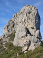
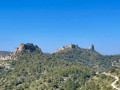
(2) Follow it to the left. A little further on, pass a track on your right which climbs up to the antennae and continue straight on along the track opposite. Stay on this track below the Tête du Grand Puech. Magnificent views over the valley and Sainte Victoire. You’ll come to a cistern marked with a boundary stone numbered 175.
(3) Carry on along the track until the next bend (to the right) and look out for a path branching off to the left.
(4) Follow it slightly higher up (blue markings). A little further on, ignore a path leading off to the left downhill and carry on straight ahead. A path comes from the right; turn left (blue markings). Pass a fire lookout post; do not take the small path to the left but carry on straight ahead. Ignore a path on the right.
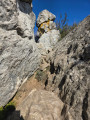
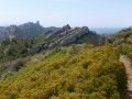
Follow the ridge. There’s a lovely view of Marseille Bay to the right. Sainte Victoire is to the left. Climb up to a small summit and then descend. The path is steep and slippery. Take care. When you reach a pass, keep to the right until you reach the next pass at an elevation of 590.
(5) Do not take the blue-marked path on the right which climbs to the summit, but keep left onto the level path which goes round the hill. A lovely path with beautiful white flowers (late April).
A path joins from the right; turn left. Follow the blue markings again. You’ll reach another pass at an elevation of 535. (Vallon de la Figuière).
(6) Leave the blue markings and turn left onto the yellow-marked path leading downwards. You’ll reach a tarmac road crossing the route (Chemin du Jas) at an elevation of 461.
(7) Turn right onto it. The markings are still yellow. Then turn left onto Chemin de la Galice, which is still marked in yellow. Further on, at the junction with a car park and rubbish bins, turn left towards the town hall. In the town hall square, there is a café (Le Cercle de l’Avenir), a bakery, a butcher’s, a mini-market and a tobacconist’s.. Cross the main road and take the street opposite, to the left of the estate agent’s. You’ll arrive at the Place des Écoles et de la Laïcité. Keep to the right until you reach Rue Neuve. Turn left. Pass Rue du Puits on your right, turn right at Place de l’Olivier and walk down the street. Pass the church on your right, keep left and continue down to the junction where there is a lovely cedar tree. There, turn right and follow this road to a junction. Turn right again, until you reach the ‘Auberge Neuve’ bus stop in Cadolive, towards Peypin (E). Car park nearby.

 Visorando Member
 Difficult
 Association / Club / Walk leader