


From Perpignan, head towards Andorra on the N116 dual carriageway. Pass Ille-sur-Têt, Vinça and Marquixanes. At the entrance to Prades, follow the bypass towards Villefranche-de-Conflent. At the third roundabout, turn right towards Cattlar. At the small roundabout at the exit of Cattlar, turn right onto Route d'Eus (D24). Park as soon as possible in the car parks. Parking spaces are also available at the church and in the town centre.
(S/E) From Route d'Eus, turn right at the church. You will arrive at a square¹. First turn left then right and follow Rue d'en Bas, which curves to the right. Join the D619 national road.
(1) At the pedestrian crossing, cross this national road with caution. Go down a little and join an irrigation canal in perfect condition, which is still very useful.
Continue along this canal via Chemin Rec de Baix, overlooking beautiful, perfectly maintained family vegetable gardens. Join Chemin du Salt Gros. Turn left onto this wide path. Cross the bridge over the Castallane. There is a signpost here.
(2) Turn right after the bridge. Continue along the stony track that climbs up to a left-hand bend.
Caution: leave the farm on your left. Do not enter the property.
Head straight ahead, following a wire fence. Descend towards a small ford on the Còrrec de les Eres, which is often dry.
(3) Head straight ahead, then immediately left, climbing up a small path that is clearly marked on the ground. Pass a first path on the right marked in yellow (return), then two other paths on the right (visible on the OSM map). Continue on the southern slope of Les Tamborines.
The well-marked path climbs westwards, then turns right towards the north-west. Cairns can also help you find your way to the fork.
Yellow markings
(4) Take the wider path on the left, which is also well marked on the ground. The path continues to climb through a Mediterranean-type forest with low vegetation. You will reach a clearing.
(5) Fork in the path. There is a roundabout with a beautiful oak tree in the middle and a signpost.
Turn left towards Llugols. The path descends a few metres, then climbs very steeply through a clearly visible grazing area. The path becomes straight after turning right to the north-west (elevation 623).
Signpost.
Note: many paths have been made by animals. But simply continue north-west on a track. Pass a large enclosure and an old bulldozer on your left.
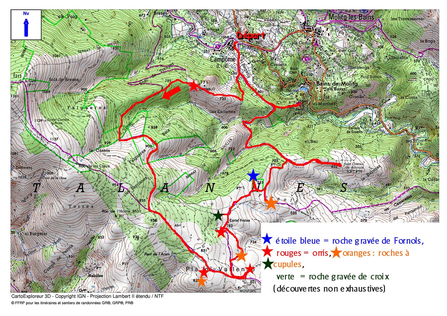
(6) Engraved rock. It is difficult to find without a GPS. There are no directional signs.
Please note: on 2 January 2020, new markings and signposts were being installed.
Follow a small path on the right for a few metres in the area marked on the IGN map after passing a very large enclosure where a construction machine has been abandoned. Return to the marked path and continue west on the track.
(7) Leave the track on the left. Set off on a large bend to the right. An old marker is still there. ³
Leave a well-marked path on the left. Please note: end of yellow markings.
After 200m, turn right at a right angle and reach an area where there are numerous tracks and the ruins of an old farmhouse.
(8) At the first fork in this area, turn left heading due west. The track then turns left towards the south-west. Continue along this track, passing Còrrec de la Serrania (around 700m). Then continue due north until the next fork.
(9) Continue along the track heading due west, leaving a path on your left (shown on the OSM and IGN satellite map). Pass Còrrec de les Serrianes. Pass Còrrec de les Escomes. Continue north until you reach the next fork with a much larger track.
Yellow markings Signpost
(10) Turn right onto this wide track, heading northeast for 350 metres.
(11) Please note: the signpost is on the left of the track at this fork. Leave the wide track. Descend steeply to the right into the forest via a path towards Orri de Carmajó, which you will reach after 150m.
Continue for another 150 metres and leave the path on the left towards Bosc de Trenyer, which descends to Campôme. Continue south-east.
At around 670m, the path turns left due north and leads to a track coming from Campôme. There is a signpost and a large, attractive retaining wall at La Feixe. ⁴
(12) Turn right onto this track, which now climbs to a fork. ‘
Alternative: From this point, turn left and then immediately right to visit the charming Catalan village of Campôme.
(13) Turn left and descend towards Château Paracolls (marked Paracols on the sign). Gaps in the vegetation offer glimpses of beautiful landscapes. Leave the track that descends to the right and arrive at the foot of the castle ruins. Then climb up to the ruins.
(14) Caution: there is a path through the castle ruins, but there are no safety barriers. The ruins have not been reinforced.
There is a small chapel still covered by a vaulted roof. Access is not prohibited, but caution is advised. From this chapel, a beautiful stone path leads down to the thermal baths of Molitg-les-Bains.
A beautiful landscape can be seen. After your visit, retrace your steps back to the previous crossroads.
(13) Now turn left and go up the track. You will come to an area with relay antennas.
Continue along the same track, which turns south-west. Ford the Còrrec del Solà and turn south at the level crossing. The track climbs again. Ford the Còrrec de la Serrania. Then turn east, climbing up to the entrance to a right-hand bend.
(15) Signpost. Leave the wide track by turning left onto a smaller track that descends eastwards. Cross an enclosure which is an animal feeding area. There is an old yellow marker here. Follow the direction of Sant Cristau de Fornols.
(16) Ruined church. You can take a break in this beautiful landscape. Go around the ruins on the right, following a small grassy track for 50 metres until you reach a left-hand bend. You will need to leave the track.
End of the yellow markings.
Please note: look out for a cairn and an engraved stone on the ground with the word Cattlar written on it on the right-hand side of this bend. Turn right onto this well-marked path. Descend towards a small stream and cross it. Cross the Còrrec de Fornollica stream (altitude 586 m) quickly and continue south-east.
Yellow markings
(5) There is a kind of roundabout with a beautiful oak tree in the middle. There is a signpost. Turn left towards Cattlar, taking the opposite path to the one you took on the way up.
(4) Turn left. Leave the descending path you took on the way up, which is normally marked with a yellow cross.
Further on (at an altitude of 435 m), ignore the path going uphill to the right.
The path to follow turns left and descends very steeply towards La Castellane. The path then turns right, running along the top of this large torrent. Do not cross it under any circumstances.
An old yellow marker still in place helps you follow the path that winds along the stream below. At the end of the right-hand bend, you will arrive at a developed area with two wooden benches, a wooden guardrail and steps made of wooden sleepers.
This is a lovely spot to take a break or snap a few photos.
(17) From this viewpoint, descend to the left via the steps.
Caution: the descent is steep. You will soon reach a first fork in the path. A sign points in the direction of a typical cabin. You can make a round trip there.
Return to the fork. A few metres further on, another fork with a signpost indicates the Salt Gros waterfall. Descend to the left along a good path.
(18) After a few rocky passages, you will see the waterfall. This is a beautiful spot to take a break and snap some great photos of the waterfall. Retrace your steps to the fork and continue straight ahead on the good path that descends with the Castallane waterfall on your left below. When you reach an open area, veer slightly to the right and you will come to a fork that you passed on the way up.
(3) Turn left, crossing the often dry stream. But this time (on the way back), follow a good path on the left that runs alongside the track you followed on the way there, just above on the right. Continue along this path, crossing a wooden bridge and wooden fall protection barriers. Further on, you will rejoin the track you took on the way there and reach the bridge.
(2) Turn left to cross the Castellane and immediately right in the opposite direction to the outward journey. Follow the canal and join the D619 national road.
(1) At the pedestrian crossing, cross this national road with caution and head to the car park at Cattlar (S/E).


