


 Country:
 City:


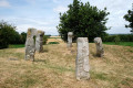
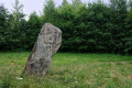

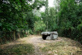
Start from Arleux Church.
(S/E) With your back to the butcher’s, face the church. Turn left onto Rue Georges Lefebvre towards Palluel via the D65 and D13.
At the roundabout, go straight on along Rue de la Chaussée until you reach Palluel.
(1) At the roundabout, on your right, just below the ‘Give Way’ sign, you’ll find thefirst stone: the Bouteroue menhir statue
At this roundabout, take thethird exit, via Rue d’en Haut onto the D21, towards Oisy-le-Verger.
Cross the bridge over the Canal du Nord.
(2) At the entrance to the village, take thefirst right onto Chemin d’Ecourt-Saint-Quentin or Rue Paul Marcel.
Cross the metal bridge over the Canal du Nord
(3) Carry on. After 700–800 metres, on your right, you’ll see a sign indicating the location of the menhir known as ‘Le gros caillou’
(4) Carry on towards Écourt-Saint-Quentin.
::5: At the entrance to the village, turn left onto Rue du Porkien. Then carry on straight ahead along Rue Henri Barbusse on the D13. Pass a ‘Carrefour-contact’ and then the Town Hall on your right.
(6) Follow the road and head towards Lécluse – Douai on the D19 via the Route de Lécluse. You’ll pass a German military cemetery on your right. You’ll arrive in Lécluse. At the stop sign, turn right onto the D956 towards Tortequesne – Hamel.
(7) Take thefirst left onto the D47 via Rue d’Étaing. Just as you leave the village, you’ll see a warehouse on your right and a small stony square on your left
(8) From there, a path leads to the menhir: La pierre du diable, about 400–500 metres away.
Return to the D47c or Rue d’Étaing at Eterpigny and, at the very end, turn right onto Rue de Recourt until you reach Étaing.
(9) At the stop sign, take the D39 or Rue de Sailly towards Sailly-en-Ostrevent – Biache Saint Vaast – Vitry-en-Artois.
(10) When you reach Sailly-en-Ostrevent, turn left onto the D43 towards Hamblain, then immediately left onto Chemin de Bapaume. Carry on and take the last track on the right.
(11) Do not cross the Autoroute des Anglais. On this track, slightly to your right (visible from the track), you will see a mound with the ‘Les sept bonnettes’ cromlech.
(12) Carry on along this track and now cross the Autoroute des Anglais. Continue on to Boiry-Notre-Dame. Enter the village.
(13) Take thesecond turning on the right, onto the D34 or Rue de l’Église. Carry on along the road, which curves to the right towards Hamblain and Vitry; continue on this road – you are now on the Route d’Hamblain.
Cross the Autoroute des Anglais again and drive on to Hamblain-les-Près.
(14) At the village entrance, at the ‘Give Way’ sign, turn right onto the D43 or Rue de Sailly towards Étaing – Sailly-en-Ostrevent.
(10) Once in Sailly-en-Ostrevent, keep left towards Vitry-en-Artois on the D39 or Rue du Pont. Pass the church on your left.
(15) At the roundabout, turn right towards Tortequesne and Noyelles via Rue du Chaufour on the D43. You will arrive in Tortequesne. Carry on straight ahead until you see the Town Hall on your left.
Carry on along the D956 or Rue de Douai towards Hamel-Arleux.
(16) Then turn right, still heading towards Hamel–Arleux or Rue du 19 mars 1962.
Take note: once you have the Hamel quarry woods on your left, a little further on, stop at the point where there are barriers on your right.
(17) On the other side, you should see, at the edge of the woodland, a sort of stone-lined fountain and, almost next to it, a signposted entrance to the dolmen: ‘La cuisine des fées’ or ‘La pierre chavatte’.
Head back towards Hamel. Once you reach Hamel, at the roundabout at the entrance, go straight on, taking thesecond exit onto Rue Jean-Baptiste Mience.
(18) At the second roundabout, take thethird exit onto Route de Douai. You’ll pass the one with the wayside cross on your left. Carry on, following the road as it curves to the left. You’ll then leave Route de Douai behind, heading towards Estrées.
When you reach Estrées, at the roundabout at the entrance, turn left, taking thethird exit onto the D135A or Rue d’Arleux. Carry on; you are now on Rue du Calvaire.
(19) At the Stop sign, turn right onto Rue du Général de Gaulle towards Gœulzin Cantin on the D135.
Then take Rue du Moulinet.
(20) At the very end, at the stop sign, turn right towards Arleux via the D65 or Rue de Douai. You’ll enter Arleux; carry on and, at the roundabout, go straight on towards the church to return to your starting point (S/E).

 Visorando Member


 Easy

