Canal de la Pisse

This hike is suitable for the whole family and will take you through the "dark" side of the Saint-Vincent-les-Forts Forest with its pine and spruce trees. You will also discover the Canal de la Pisse, an old irrigation system that is still in use today.

Details

138940
Creation:
Last update:
Last review:
  • Walking
    Activity: Walking
  • ↔
    Distance: 6.65 km
  • ◔
    Average duration: 2h 30 
  • ▲
    Difficulty: Easy

  • ⚐
    Back to start: Yes
  • ↗
    Ascent: + 203 m
  • ↘
    Descent: - 195 m

  • ▲
    Highest point: 1,444 m
  • ▼
    Lowest point: 1,273 m

Photos

Description of the walk

Yellow PR® and yellow and red GRP® markings
Park in the car park at Saint-Vincent-les-Forts.

(S/E) Join the forest tracks at a place called Les Quatre Chemins.

(1) Turn right towards Canal de la Pisse. After 250m, you will reach the Dantane point.
.
(2) Follow the track climbing up to the left (yellow markings) to Serre Sarlier.

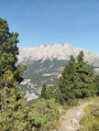
(3). Turn left, then after a few metres, turn right to rejoin the Canal de la Pisse. Follow the flat path on the left. On this section, the canal is underground for about 300 metres, then flows in the open for just under 1.5 kilometres. It then crosses a forest track: cross it and follow the canal for another 350 metres to Le Canal. This is the most pleasant part of the circuit, walking along a gently sloping path alongside the canal, surrounded by majestic fir and spruce trees, which are a very important resource for the commune of Saint-Vincent-les-Forts.

(4) Take the path that descends to the left to Clot du Dou.

(5) Turn left onto the beautiful forest track and continue for 350 metres on a tarmac road (GRP® red and yellow markings) until you reach the Quatre Chemins and the village.

(1) Turn right to reach the car park at Saint-Vincent-les-Forts (S/E).

Waypoints

  1. S/E : km 0 - alt. 1,273 m - Saint-Vincent-les-Forts car park - View of the - Lac de Serre-Ponçon
  2. 1 : km 0.25 - alt. 1,284 m - 4 paths
  3. 2 : km 0.58 - alt. 1,310 m - Dantane
  4. 3 : km 1.03 - alt. 1,378 m - Serre Sarlier
  5. 4 : km 3.46 - alt. 1,444 m - Canal
  6. 5 : km 3.64 - alt. 1,406 m - Clot du Dou
  7. S/E : km 6.65 - alt. 1,274 m - Saint-Vincent-les-Forts car park

Notes

Please note that the map and GPS track may be inaccurate, so hikers should follow the route as it appears on the ground, including trails, marked paths, signposts and cairns. In all cases, the direction of the route and experience are the best guides.
Be sure to adapt the route to the most limited abilities within the group.
Please note that the route on the IGN map indicates that the trail crosses the forest track once and passes over it, then passes under it again, but this is not the case. In reality, the trail only crosses the forest track once, just before the canal. The trail is always on the right bank of the canal
Alternative route: Les Sources de la Pisse (+ 1.5 hours, + 450m elevation gain) for experienced walkers only.
This variant of the Canal de la Pisse will take you up to the sources of the Pisse at an altitude of 1,850 metres. You can admire the various resurgences that feed the torrent as it descends through a series of beautiful little waterfalls before plunging into the Vallon de Château Rolland.
To do this, at (4), head towards Pré Balou / Sources de la Pisse via a fairly steep climb through the pine trees. After about a hundred metres, this comes out onto a wide path, turn left. After about 400 metres, the path becomes a simple trail. Follow the yellow and red markings ofthe GR® de Pays du Tour de Serre-Ponçon to the summit at Sources de la Pisse (1,850 metres) (the sign is missing, you have arrived when the trail crosses the stream; be careful, as you will cross a first stream shortly before arriving). Once there, you can continue climbing off the trail for 200 to 300m on the left bank of the stream, going around the waterfalls to come out in the large valley where the water resurfaced.
The descent is via the same route to (4). Continue the descent to Clot du Dou (1,420 m). Continue to the car park at the start (S/E).

Worth a visit

Between (3: and) 4:: The water flowing in the canal is collected at an altitude of 1,450 m in the Ravin de Pré la Pierre, through which it descends from the slopes of Dormillouse. This structure underwent major renovation work in 2005. It is now regularly maintained and cleaned by the staff of the Community of Communes and still provides a valuable resource for irrigation for some local farmers and gardeners.
(5) Clot du Dou: a large clearing where Hannibal is said to have set up camp during his crossing of the Alps in 218 BC.

 Always be cautious and plan ahead when you're outdoors. Visorando and the author of this route cannot be held responsible for any accidents occurring on this route.

The GR® and PR® markings are the intellectual property of the Fédération Française de Randonnée Pédestre.

Reviews and comments

4.8 / 5
Based on 23 reviews

Reliability of the description
4.8 / 5
Ease of following the route
4.8 / 5
Route interest
4.9 / 5
User 27323924

Overall rating : 5 / 5

Date of your route : Sep 16, 2025
Reliability of the description : ★★★★★ Very good
Ease of following the route : ★★★★★ Very good
Route interest : ★★★★★ Very good
Very busy route : Yes

very good for summer because it is very shady

Machine-translated

User 18602697

Overall rating : 5 / 5

Date of your route : Jul 28, 2025
Reliability of the description : ★★★★★ Very good
Ease of following the route : ★★★★★ Very good
Route interest : ★★★★★ Very good
Very busy route : No

A very refreshing route that is accessible to everyone

Machine-translated

Louis REVENU
Louis REVENU

Overall rating : 4.7 / 5

Date of your route : Jul 23, 2024
Reliability of the description : ★★★★☆ Good
Ease of following the route : ★★★★★ Very good
Route interest : ★★★★★ Very good
Very busy route : No

A lovely outing for a hot day, the entire route is shaded and the small canal provides a little coolness. The trail is very easy.
The description is slightly inaccurate; the circuit seems shorter and with less elevation gain, according to Apple and Garmin.
A bonus after point 4 is an area with tables and benches

Machine-translated

Villadosia
Villadosia

Overall rating : 5 / 5

Date of your route : Jul 12, 2024
Reliability of the description : ★★★★★ Very good
Ease of following the route : ★★★★★ Very good
Route interest : ★★★★★ Very good
Very busy route : No

Hello,
We did the route in reverse as it was easier with a Joëlette. The walk along the canal is superb and cool. We had a picnic at Clos du Dou (be aware that it can get busy as it is accessible by car...
The view of the lake on the Ubaye side from the paragliding take-off point is simply breathtaking!

Machine-translated

patricebeaufort
patricebeaufort

Overall rating : 5 / 5

Date of your route : Sep 21, 2023
Reliability of the description : ★★★★★ Very good
Ease of following the route : ★★★★★ Very good
Route interest : ★★★★★ Very good
Very busy route : No

with overcast weather, we enjoyed this pleasant route through the woods, following a charming little canal and taking some beautiful photos. Highly recommended

Machine-translated

marrirando
marrirando

Overall rating : 5 / 5

Date of your route : Aug 20, 2023
Reliability of the description : ★★★★★ Very good
Ease of following the route : ★★★★★ Very good
Route interest : ★★★★★ Very good
Very busy route : No

A very pretty, shaded trail that is fun for children.

Machine-translated

organier57
organier57

A pleasant, shaded walk with water flowing alongside for half the route. Very peaceful. Easy to do with children.

Machine-translated

nomisimon
nomisimon

Overall rating : 4.7 / 5

Date of your route : Jun 18, 2023
Reliability of the description : ★★★★★ Very good
Ease of following the route : ★★★★★ Very good
Route interest : ★★★★☆ Good
Very busy route : No

A beautiful hike in the forest. We enhanced the route by passing through the old Chatelard battery, which offers a panoramic view of the Ubaye Valley

Machine-translated

gilles_v4
gilles_v4

Overall rating : 5 / 5

Date of your route : Aug 22, 2022
Reliability of the description : ★★★★★ Very good
Ease of following the route : ★★★★★ Very good
Route interest : ★★★★★ Very good
Very busy route : No

A short, very bucolic walk in the shade with the sound of water in the background

Machine-translated

rumax
rumax

Overall rating : 5 / 5

Date of your route : Sep 13, 2021
Reliability of the description : ★★★★★ Very good
Ease of following the route : ★★★★★ Very good
Route interest : ★★★★★ Very good
Very busy route : No

A beautiful walk through the woods along a well-maintained canal.
When you reach the trail, if you turn your head towards the woods, the last glimpse of them from below is magnificent.
This route is ideal in summer and accessible to the youngest members of the family.
I didn't have enough time to do the alternative route to the sources of the Pisse, which is a real extension of the "canal" section for those who enjoy a bit of walking.
And why not add the Châtelard battery to the same day?

Machine-translated

Mandara
Mandara

Overall rating : 5 / 5

Date of your route : Sep 12, 2021
Reliability of the description : ★★★★★ Very good
Ease of following the route : ★★★★★ Very good
Route interest : ★★★★★ Very good
Very busy route : No

A beautiful, refreshing hike along the pretty La Pisse canal, shaded throughout, ideal for summer even in hot weather. Start from the large paragliding take-off car park, which we were lucky enough to admire on the day! We started with a short climb that took us to the canal, which we followed on almost flat ground, accompanied by the gentle sound of the water and the shade of the fir and spruce trees. Up to this point, it was a very easy walk, even with children or Sunday walkers At point 4, we chose the alternative route and climbed up to the springs via Pra Balou. The climb was quite steep and a little challenging for us as we only walk occasionally, and it took us about two hours to get there, progressing slowly. The effort is well rewarded by the beauty of the place, the beautiful waterfalls and the wild and unspoilt nature of the site. Be sure to follow the red and yellow GRP markings carefully, as several paths branch off in different places. We returned as described by the Hannibal camp, where picnic tables and a useful shelter in case of rain await you. The descent is easy along a beautiful forest track.

Machine-translated

patembrun
patembrun

Overall rating : 4.3 / 5

Date of your route : May 22, 2021
Reliability of the description : ★★★★☆ Good
Ease of following the route : ★★★★☆ Good
Route interest : ★★★★★ Very good
Very busy route : Yes

A beautiful hike combining historical interest with nature. We enjoyed visiting the Châtelard battery and, above all, the view of the valley from the end of the battery.

Machine-translated

The user account associated with this content has been deleted.

jccollin
jccollin

Overall rating : 5 / 5

Date of your route : Aug 26, 2019
Reliability of the description : ★★★★★ Very good
Ease of following the route : ★★★★★ Very good
Route interest : ★★★★★ Very good

As a family with three children who enjoy walking (aged 10, 7 and 5), we enjoyed the route, which we followed in an anti-clockwise direction. The first climb warmed up the little ones' legs, but once we reached the canal, it was extremely pleasant and shaded. Before heading back, we continued on to the Chatelard battery, with a narrow but steady climb, and the pleasure of following in the footsteps of Hannibal made us forget our tiredness. We then returned via the path indicated towards St Vincent, a wide, easy path to the road that leads back to the car park. A children's playground with a drinking fountain was very much appreciated!

A really enjoyable route.

Machine-translated

AlixEtFrançois
AlixEtFrançois

Overall rating : 5 / 5

Date of your route : Jul 29, 2019
Reliability of the description : ★★★★★ Very good
Ease of following the route : ★★★★★ Very good
Route interest : ★★★★★ Very good

We did it the other way around, but we think it's better to go back down with the canal.

Machine-translated

Other walks in the area

For more walks, use our search engine .

The GPS track and description are the property of this route's author. Please do not copy them without permission.