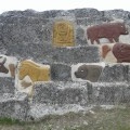
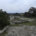
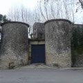
This short route through the village of Saint-Chaptes in the Gard allows you to discover the rocks sculpted in open garrigue and also gives you a view over the village, its old narrow streets and its castle.
(D) Leaving the Champ de Foire (fairground), head to the right on to Avenue de la République for 40 metres. You will come to a crossroads with a Protestant church on your left with the first fountain beside it.
Take the narrow street facing you between the building and the pharmacy, which leads to Place Ducros.
At the Place, turn immediately right to take the first narrow street, Rue du Four.
Follow this narrow street and turn left at the first narrow street you meet. It leads to Place de l’Église, the second church in the village (Catholic). Go around the left-hand side of the church and take Rue Peirre Ducros.
(1) Turn right, advance down Avenue Raoul Vezol and pass by the front of the castle on your right. Continue onwards and pass in front of the post office on your left until you reach a crossroads. Take a left down Rue de la Tour and continue on for about fifty metres.
(2) Then take a left turn, before the tight bend, on to Chemin des Roques, the first part of which is tarmacked. After crossing over the stream which runs alongside the village, the Chemin des Roques is no longer tarmacked. Continue straight ahead, following the track until you reach the second crossroads situated at the corner of the large rocks to be visited.
Take the path to the left, then head to the right towards the structure with the famous contemporary sculptures, which overlooks the surrounding garrigue.
(3) On the rocks, you can see Mont Bouquet on the horizon to the north. Towards the east, depending on the weather, you can just make out Mont Ventoux in the distance.
After visiting the rocks, return to the path which you left, heading due north, and follow this path straight ahead passing by an initial intersection on your right.
(4) At the next crossroads, turn left onto a straight path - an old railway line, which was dismantled during the second world war. Follow this path until you reach the next crossroads where you turn left.
(5) Go over the bridge crossing the Ruisseau de l'Arrière (Back Stream) and take the left heading towards the village and the first houses to end up in Rue Adrien Levat.
At the end of the road, take a right angle turn on to the Grand-Rue and pass by the front of the first church again on the right-hand side. Follow Avenue de la République in order to return to your point of departure on your left (A).
Waypoints :
D/A : km 0 - alt. 75m
1 : km 0.37 - alt. 76m - On the right, Avenue Raoul Vezol
2 : km 0.63 - alt. 74m - Chemin des Roques
3 : km 2.2 - alt. 83m - Sculpted Rocks
4 : km 2.6 - alt. 82m - Old railway line
5 : km 3.35 - alt. 77m - Bridge over the Ruisseau de l'Arrière (Back Stream
D/A : km 4.43 - alt. 75m
- Depart from, and return to, the Champ de Foire, with parking available.
- Easy hike on well-maintained paths, also possible on mountain/hybrid bikes.
- Take some water with you in the summertime.
- Standard hiking wear.
Visorando and this author cannot be held responsible in the case of accidents or problems occuring on this walk.
To see:
- The village's old narrow streets, historic villages which are typical of the South of France.
- Two churchs (Catholic and Protestant), fountains.
- Delighful farm, family recreation park.
- 12th century chateau (visits are possible in July & August by appointment only).
- Garrigue landscape: alternating sections of crops (cereals and/or vegetables) and vines.
- Duché d'Uzès 15km away, Nîmes 20km away, Alès 40km away, Pont du Gard 30km away.
- Due to its position, Saint-Chaptes acts as a central base from which you can easily explore the area: from heading off to explore the Carmargue, to visiting the edge of the Cévennes mountains.
Events in the village:
-Town festivals in August,
- Witches' Fesitval on 1 November,
- The Camargue Races take place many times throughout the year, in arenas.
Global average : 3.83/5
Number of opinions : 2
Description quality : 4.5/5
Routemap quality : 4/5
Walk interest : 3/5
Global average : 3.67 / 5
Date of walk
: 28/01/18
Description quality
: Good
Routemap quality
: Good
Walk interest
: Average
Directions conflicted with French walking signs which caused some confusion. (their loop was to the East whereas hikideas was to the West!)
Global average : 4 / 5
Date of walk
: 15/10/17
Description quality
: Very good
Routemap quality
: Good
Walk interest
: Average
A good excuse to get out in the country but generally a somewhat drab walk. The sculpted rocks are a bit strange and underwhelming but this is a good jaunt to stretch the legs.
A circuit around Uzès, discovering the Eure valley and its source that once fed the city of Nimes, then a loop through Gardoise scrubland to return to Uzès.
A hike mostly through forest, under the canopy of the Bois de Lens.
Throughout the walk you'll experience stunning scenery.
You'll also discover the Pielles Roman quarry, Macassargues caves (which were occupied by Neanderthal man), the pre-Roman sanctuary of Mabousquet (1st century BC), the Clunisian abbey of Jouffre (3rd century) and the Castellas de Montmirat (11th century).
A walk beginning above the Gardon Gorges and continuing down along Gardon River. Please note that part of the route crosses an area destroyed by fires in 2017.
Family outing visiting the beautiful site of Collias Hermitage.
A walk in scrubland from Langlade to the Gallo-Roman site of the Oppidum de Nages offering a view of the entire Vaunage with the Cevennes, the sea and Pic-Saint-Loup in the distance.
It ends with a visit to the village of Langlade with its narrow streets, mill, its temple, its 2 squares... and its ancient houses.
Easy hike where you can discover the Pont du Gard and its environment.
At Sernhac, south of Remoulins and Saint Bonnet du Gard, there are two tunnels that flank a small nice valley. The Perrotte and Cantarelles tunnels. Head through them to discover the chimneys by which men lowered equipment and raised the rubble during excavation. One can see traces of blows of pickaxes and holes for oil lamps. Today it is a quite popular place to find some shade and cool off for the villagers.
Amid hills and valleys, a bull ranch (manade) under the pine trees, abandoned quarries, and quaint villages with narrow, shady lanes. A wonderful glimpse of the Gard.
For more walks, use our search engine.
The GPS track and description are the property of the author.