Country:
 City:
City:


Below the town hall, the PR® starting sign is located near the car park.
(S/E) From the car park, head towards the church. Take the street in front of the town hall. Continue left along the road, passing a fountain.
(1) In Loumagne, continue left along the stony path, which becomes a dirt track, until you reach a Fork in the road.
(2) Turn left and join the D291.
(3) Take the road on the left, then, at Terraube, turn right.
(4) Continue to the right along the Chemin de Traoués. At the water tower, turn right onto the grassy track. Walk alongside the woodland on your right. When you reach a field, head down to the right along the woodland, skirting the field. Reach the bottom of the valley and a track (on the left, a memorial stone to a fallen resistance fighter).
(5) Turn right to rejoin the D291 (Route du Maquis de Meilhan) and follow it to the left. Pass in front of the memorial site. Reach the junction at the top of the hill.
(6) Turn right onto the grassy track towards Laumo.
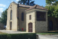
(7) At the small road, turn right. At the farm, continue to the left and head for the Chapel of Lasseube (Chapelle Saint-Laurent), where two members of the Maquis were shot dead.
(8) Retrace your steps to rejoin the original path.
(7) Carry on to the right.
(9) You’ll come out onto the D238; follow it to the right! Walk 1.4 km (take care) until you reach a plateau.
(10) Carry on to the right along the Chemin de Monties. Go straight on to Lauzerou and continue along a dirt track for 750 m to return to the original junction.
(2) Take the path back in the opposite direction and head back to the village (S/E).
 Visorando Member
 Moderate

 Tourist office
 Tourism professional