Water hike on the Roanne

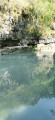
A family-friendly water walk to explore the Roanne and cool off.

Please note: Walking times are calculated for routes on dry land; walking in the water is much more difficult. You should allow for a speed of around 1.5 to 2 km/h on this stretch of river, which equates to approximately 5 to 6 hours’ walking for the entire route.

Details

n°644584
Creation:
Last update:
Last review:
  • Walking
    Activity: Walking
  • ↔
    Distance: 6.04 mi
  • ◔
    Average duration: 3h 00 
  • ▲
    Difficulty: Moderate

  • ⚐
    Back to start: Yes
  • ↗
    Ascent: + 256 ft
  • ↘
    Descent: - 262 ft

  • ▲
    Highest point: 1,647 ft
  • ▼
    Lowest point: 1,467 ft

Photos

Description of the walk

Park at the junction of the D135 and the D140 (you can park by the bridge on the D140, but there are only two or three spaces).

(S/E) From the junction, turn left and head downhill along the D140 for about 300 metres. Cross the bridge and, immediately afterwards, take a path on the right. You’ll reach a small meadow; follow the river on your right. At the end of the meadow, look out for a path on the right that leads down to the confluence of the Brette and the Roanne. Descend into the riverbed.

(1) Follow the right-hand branch to head upstream along the Roanne. The river is cut into a steep gorge at the start, but after a few bends, the view opens out as you approach Pradelle (on your right). Continue to the bridge at a place called Le Moulin.

(2) Turn round and walk back down the river in the opposite direction to return to your car (S/E).

Waypoints

  1. S/E : mi 0 - alt. 1,532 ft - Junction of the D135 and D140
  2. 1 : mi 0.25 - alt. 1,470 ft - Confluence of the Roanne and the - Brette (rivière) - Affluent de la Roanne
  3. 2 : mi 3.02 - alt. 1,640 ft - A place known as Le Moulin. Bridge over the - Roanne (rivière)
  4. S/E : mi 6.04 - alt. 1,532 ft - Junction of the D135 and D140

Notes

This route is flexible as it is a return trip along the river; participants are free to turn back according to their preferences and physical abilities.
By shortening the distance, the route can be classified as ‘Easy’.

Walking in the water isn’t as easy as it sounds; walking poles can help you keep your balance.

Alternative route:

(1) The description suggests walking upstream along the Roanne, but at the confluence of the two rivers (1), you can choose the left-hand branch to walk upstream along the Brette – a slightly more challenging route but with opportunities for swimming in certain places (the Serre Pointu rapids).

Reviews and comments

4.7 / 5
Based on 1 review

Reliability of the description
5 / 5
Ease of following the route
5 / 5
Route interest
4 / 5
Domdomi
Domdomi

A walk I haven’t done yet.

Machine-translated

TOULAUD'RANDO
TOULAUD'RANDO

Overall rating : 4.7 / 5

Date of your route : Jul 04, 2023
Reliability of the description : ★★★★★ Very good
Ease of following the route : ★★★★★ Very good
Route interest : ★★★★☆ Good
Very busy route : No

A magnificent walk thanks to its route through the Roanne valley, including a stretch through gorges whose sheer height is impressive.
There are a few pools where you can take a dip on a hot day.
I’d definitely do it again.

Machine-translated

Other walks in the area

For more walks, use our search engine .

The GPS track and description are the property of this route's author. Please do not copy them without permission.