Puig de Garces, Pla Bulat and the orientation table in Céret

A short hike up to Puig de Garces (674 m), a hill overlooking Céret. A circular route passing through Pla de Bulat, then descending via a path leading past the orientation table. Return via the Route du Balcon de Céret.

Details

47993545
Creation:
Last update:
Last review:
  • Walking
    Activity: Walking
  • ↔
    Distance: 5.47 mi
  • ◔
    Average duration: 4h 00 
  • ▲
    Difficulty: Difficult

  • ⚐
    Back to start: Yes
  • ↗
    Ascent: + 1,709 ft
  • ↘
    Descent: - 1,690 ft

  • ▲
    Highest point: 2,208 ft
  • ▼
    Lowest point: 568 ft

Photos

Description of the walk

Start from the Chamber of Commerce and Industry car park, 6 Boulevard Simon Batlle. Park in the pay-and-display car park at the Céret Sub-Prefecture (€2).

(S/E) With your back to the car park, turn left onto Boulevard Simon Batlle and walk for about 80 metres.

(1) Turn right onto Rue des Évadés de France (D13f).

(2) Keep left (south) at the three-way junction to follow Rue Edmond Brazès, then leave this street at the bend to take a path on the right. When you reach the Font Hélena junction, located before a tennis court, turn left.

(3) Turn right: this is a diversion, as the path has been altered by the owners of the Mas d’en Cirera. Join a track.

(4) Head up the track and follow it to the right until you reach a junction (elevation 308).

(5) Leave the track and take a path on the left which leads further up to the Route de la Forêt at a hairpin bend. Head left along the road for a few dozen metres, then rejoin the path on the left, which crosses the road several times. You’ll reach a junction.

(6) Route modified: turn left and join a track, following it to the right for about a hundred metres.

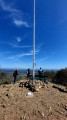
(7) Take the path on the left and head for the summit of Puig de Garces (elevation 674). Please note: there is no path to the summit; you must follow any visible tracks on the ground. If you hear bells, these are goats being watched over by a Patou dog. The same applies on the descent after the summit.

(8) Begin the descent to the right, heading south, to reach Pla Bulat (altitude 640), a junction of roads and tracks, an ideal spot for a picnic.

(9) Turn left onto the descending path and, after 300 m, you’ll reach a junction (elevation 609). Keep left and continue down.

(10) Head left for the direct descent: you can turn right for a gentler descent. You’ll come out onto a track.

(11) Head straight ahead, crossing the track four times to reach the Route du Balcon de Céret.

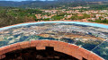
(12) Turn left to reach the orientation table with a view over the town of Céret.

(13) Turn back.

(12) Take the path down to your left, keep left at the fork and rejoin the road at Clé Vacances.

(14) Cross the road and head down the path almost directly opposite. Further down, continue along this path on your left, ignoring the Yellow Cross, to reach Rue Aristide Maillol after el Castellàs. Continue towards the Sub-Prefecture.

(1) Head straight ahead to return to the starting car park (S/E).

Waypoints

  1. S/E : mi 0 - alt. 568 ft - Sous-Préfecture car park
  2. 1 : mi 0.08 - alt. 587 ft - Junction of the circular loop
  3. 2 : mi 0.35 - alt. 663 ft - Three-way junction, turn left
  4. 3 : mi 0.79 - alt. 1,001 ft - Take the detour to the right
  5. 4 : mi 0.85 - alt. 1,119 ft - Return to the track
  6. 5 : mi 1.12 - alt. 1,047 ft - Path on the left
  7. 6 : mi 1.88 - alt. 1,572 ft - Altered path, to the left
  8. 7 : mi 2.07 - alt. 1,752 ft - Path on the left
  9. 8 : mi 2.43 - alt. 2,201 ft - Puig de Garces
  10. 9 : mi 2.91 - alt. 2,096 ft - Pla Bulat
  11. 10 : mi 3.74 - alt. 1,617 ft - Direct descent on the opposite side
  12. 11 : mi 3.9 - alt. 1,499 ft - Junction with the track
  13. 12 : mi 4.54 - alt. 988 ft - Balcon de Céret Route
  14. 13 : mi 4.65 - alt. 1,027 ft - Orientation table, viewpoint
  15. 14 : mi 4.91 - alt. 840 ft - Clé Vacances
  16. S/E : mi 5.47 - alt. 568 ft - Sous-Préfecture car park

Notes

Please note that there is a car park charge of €2; our payment was valid from 9.30 am to 4.30 pm.

Some parts of the route are quite challenging; good walking shoes are recommended.
Once past the summit, there’s a gentle descent to Pla Bulat, an ideal spot for a picnic.

Continue the return journey via the panoramic viewpoint and the path leading into Céret.

On the climb up to Puig de Garces, there is no defined path: follow the tracks or blue markings.
This section is classified as ‘difficult ’.

Reviews and comments

3.7 / 5
Based on 5 reviews

Reliability of the description
3.8 / 5
Ease of following the route
3 / 5
Route interest
4.4 / 5
MITCH DUG
MITCH DUG

Overall rating : 4 / 5

Date of your route : Aug 02, 2026
Reliability of the description : ★★★★☆ Good
Ease of following the route : ★★★☆☆ Average
Route interest : ★★★★★ Very good
Very busy route : No

I completed the Super Route on 31/07/26. To tackle it successfully, you need to be well prepared and in reasonably good physical shape. The final section is particularly challenging. I would advise against attempting it in bad weather (rain or high humidity), as the route can be very dangerous. Otherwise, it’s mostly in the shade and quite pleasant in that respect.

It’s also a good idea to use the GPS track to avoid getting lost in the forest, where the paths are poorly signposted or not signposted at all, especially at the start and finish of the Puig de Garces section. Despite the partly cloudy conditions that day, the views were truly spectacular.

I’d like to offer a word of caution regarding the difficulty ratings: I recently walked the Belvédère de la Mousquière in Quillan and found it more difficult than this one. The ratings are therefore somewhat subjective.

However, this route is definitely worth doing and I’ll certainly be doing it again in the near future.

Machine-translated

Doumic
Doumic

Overall rating : 4.7 / 5

Date of your route : Apr 03, 2026
Reliability of the description : ★★★★★ Very good
Ease of following the route : ★★★★☆ Good
Route interest : ★★★★★ Very good
Very busy route : No

A hike that is partly sheltered from the Tramontane (except at Pic de Garces!!!).
Beautiful views over the plain and a fairly shaded path.
As expected, we ‘lost’ the path a little around the Mas d’en Cirera and just a little further on. No big deal; by following the trail, we found it again without any trouble a little further up.
We took a detour to extend the walk a little: when the path reaches the Route de Céret, instead of turning left at point 12, we went down to the right, along the path leading to the Porte de Fer, before heading back up to the orientation table.

Machine-translated

User 21822409

Overall rating : 1.3 / 5

Date of your route : Jun 23, 2025
Reliability of the description : ★☆☆☆☆ Very disappointing
Ease of following the route : ★☆☆☆☆ Very disappointing
Route interest : ★★☆☆☆ Disappointing
Very busy route : No

We had to turn back – the signposts aren’t very clear and the yellow markings stop before you reach Puig de Garces; you only come across crosses… disappointing

Machine-translated

rickou66
rickou66
• Edited:

Overall rating : 4 / 5

Date of your route : Nov 12, 2024
Reliability of the description : ★★★★☆ Good
Ease of following the route : ★★★☆☆ Average
Route interest : ★★★★★ Very good
Very busy route : No

It’s a shame that the start of the route is a bit vague; there’s a risk of making plenty of navigation errors (from point 1 to point 8).
The route is quite challenging for beginners, but the charm of the natural surroundings and the beauty of the scenery make up for the effort.

Machine-translated

Frédéric66
Frédéric66
• Edited:

Overall rating : 4.7 / 5

Date of your route : Nov 10, 2024
Reliability of the description : ★★★★★ Very good
Ease of following the route : ★★★★☆ Good
Route interest : ★★★★★ Very good
Very busy route : Yes

A lovely little walk, mostly through chestnut woodland. Beautiful views over Céret and the plain. A few steep sections on the way up. The app is very useful, as there are several junctions.

Machine-translated

Other walks in the area

For more walks, use our search engine .

The GPS track and description are the property of this route's author. Please do not copy them without permission.