
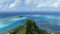
Maupiti Mountain (Polynesia)

Maupiti is a small island in the Society Islands, west of Bora Bora; its summit is not very high (372m) and you can climb to the magnificent viewpoint just below it (366m) in about an hour.
The view is splendid, stretching 270° southwards across the lagoon and towards the single pass situated between the two small motus.

Details

n°1163064
Creation:
Last update:
Last review:
  • Walking
    Activity: Walking
  • ↔
    Distance: 1.48 mi
  • ◔
    Average duration: 1h 40 
  • ▲
    Difficulty: Moderate

  • ⚐
    Back to start: Yes
  • ↗
    Ascent: + 1,099 ft
  • ↘
    Descent: - 1,099 ft

  • ▲
    Highest point: 1,135 ft
  • ▼
    Lowest point: 36 ft

Photos

Description of the walk

The start, if approaching from the south (from the harbour), is located past the Tarona snack bar. It is no longer at the steps (50m from Tarona) (the path is marked on the map between the road and the WP1 mast), but a little further on (300m from Tarona). If necessary, you can leave your bikes there (there are very few cars on the island; see the practical information).

(S/E) Head west and follow a grassy track which, after 100m, becomes tarmac for about 50 metres where the gradient is steeper. The tarmac section is clearly visible from the road; the markings are yellow.

(1) The path, rejoining the old route, turns right at the mast. Go completely round the mast’s fence on the left to climb a rocky section on the path at this point. Do not follow the track that heads off through the vegetation opposite. After 100 metres, a new path branches off to the right, leaving the old route, which is no longer maintained.

(2) Four successive ropes with knots help you negotiate the rocky sections, which can be slippery. The section is well secured. This brings you to the promontory just before the island’s summit.

Climbing up the rocky outcrop on the left, you can admire the panoramic view (photo). On your way down from the outcrop, you can also follow the path which continues through the vegetation. 20 metres further on, and a little higher up, there are solar panels. From here, you look out slightly over the previous headland.

(3) The return journey follows the same route back to the road (S/E).

Waypoints

  1. S/E : mi 0 - alt. 36 ft - Start/end of the trail
  2. 1 : mi 0.23 - alt. 154 ft - Antenna
  3. 2 : mi 0.59 - alt. 837 ft - Rope section
  4. 3 : mi 0.74 - alt. 1,135 ft - Summit
  5. S/E : mi 1.48 - alt. 36 ft - Start/end of the trail

Notes

Maupiti is a small island with a few guesthouses offering accommodation, located on the island itself and on the motus. There are no hotels or campsites. The road that circles the island is only 9 km long. So even though there are vehicles on the island, visitors mainly get around by boat (between the motus and the main island) and on foot or by bike on the island itself. It takes just under an hour to cycle round the island.

If you’re staying at a guesthouse on a motu, a return boat service is often offered around 4.00–4.30 pm. It’s therefore a good idea to set off on the hike fairly early in the morning (when it’s cooler), then cycle round the island. To the west (Terei’a), the spot is ideal for relaxing.

The base map (OpenStreetMap) does not show contour lines with the correct altitudes, but there is indeed, as indicated, a path that crosses the island from east to west. The summit (Te Uru Fa’atu, 372m) is situated in an area covered in vegetation, so the view from there is not as impressive as from the headland. The headland, with its viewpoint at an altitude of 366m, lies to the east of the summit. This hike therefore naturally follows the eastern side of the island. In terms of elevation gain and loss, you can expect a total of 346m of ascent and descent.

There is little point in going to the summit (372m) but, from (3), you can continue along the path, pass over the summit and then descend via the western side to rejoin the cross-island road. A race is organised which follows this path, so it is passable from start to finish.

Reviews and comments

4.2 / 5
Based on 2 reviews

Reliability of the description
4 / 5
Ease of following the route
3.5 / 5
Route interest
5 / 5
User 15508851

Overall rating : 4.3 / 5

Date of your route : Jun 01, 2026
Reliability of the description : ★★★★☆ Good
Ease of following the route : ★★★★☆ Good
Route interest : ★★★★★ Very good
Very busy route : Yes

A lovely hike lasting around two hours (not including drink breaks!), so best done in the morning! There are a few technical sections, with ropes towards the end of the climb. Avoid this route after rain, as the descent is more challenging. For me, it’s one of the most beautiful hikes in French Polynesia – the view from the top is fabulous!

Machine-translated

Monloulou71
Monloulou71

Overall rating : 4 / 5

Date of your route : Mar 31, 2025
Reliability of the description : ★★★★☆ Good
Ease of following the route : ★★★☆☆ Average
Route interest : ★★★★★ Very good
Very busy route : Yes

A walk I went on with my wife in glorious sunshine, setting off at 7.20 am (it was already quite warm and we regretted not having set off an hour earlier). There are a few red arrows, but the route is very poorly signposted. Luckily, I’d downloaded the route track, which meant we didn’t get lost. The climb is very steep, particularly the sections with ropes. You have to scramble over the rocks. After 1 hour 25 minutes (including plenty of breaks), we reached the foot of the headland and wondered why a rope hadn’t been put in place to help us haul ourselves up onto the boulders. The reward for all that effort is this incredible view of the village, the lagoon and the Maupiti pass. SPECTACULAR. The descent is treacherous and really takes it out of your calves and thighs. At over 60 years old, we suffered from muscle aches for two days, but we have no regrets – this hike is a must-do in Maupiti, provided you’re wearing suitable footwear (we did, after all, come across a man in flip-flops who made it to the summit without any trouble), do it in dry weather, and – as far as I’m concerned – don’t take children under the age of 10.

Machine-translated

For more walks, use our search engine .

The GPS track and description are the property of this route's author. Please do not copy them without permission.

