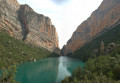
The Walls of Finestras from Monfalco

Please note: this is a spectacular hike and a long walk (9 hours’ walking, not including the numerous photo stops and picnic breaks).
The Walls of Finestras: a natural barrier in the heart of the countryside, appearing out of nowhere, surrounded by hills and a lake with turquoise water.

Details

n°25886217
Creation:
Last update:
Last review:
  • Walking
    Activity: Walking
  • ↔
    Distance: 14.12 mi
  • ◔
    Average duration: 9h 20 
  • ▲
    Difficulty: Difficult

  • ⚐
    Back to start: Yes
  • ↗
    Ascent: + 3,228 ft
  • ↘
    Descent: - 3,264 ft

  • ▲
    Highest point: 2,661 ft
  • ▼
    Lowest point: 1,660 ft

Photos

Description of the walk

Be sure to park in the Auberge Montfalco car park (300 m before the actual start of the walk).
The last two kilometres by car are along a well-maintained track. No 4x4 required.

(S/E) Take the wide, motorable track leading down from the inn and follow the signposts for thePR®-HU201 hiking trail (yellow and white).
Your first destination is the abandoned village of Fet (2-hour walk).

(1) Leave the track to enter the forest and begin your first descent.

(2) At the end, turn right onto another track and continue along thePR®-HU201 trail.

(3) Leave the track to join the path on your left (clearly marked with an arrow).

(4) A short 3-metre ‘Via Ferrata’ section, fitted to the rock face. When we passed through, one of the three pitons was missing. No difficulty in dry weather. Now head back up towards Fet, following a gentle slope.

(5) Leave the path and walk a few metres up a track suitable for vehicles; you’ll find the path continues on your left, still clearly signposted.

(6) Turn left onto the track. There should have been a sign 200 metres further on indicating to continue on thePR®-HU201 path to the left, but we couldn’t find it.

(7) Leave the track by taking a path on the left (no signposting at this point).

(8) After 200 m, the path is not well maintained; you’ll see the ‘Fet’ sign.
The route here isn’t clearly marked. We wandered amongst the houses of the abandoned village until we reached a superb viewpoint behind the old Romanesque church.

(9) Continue on your way towards Finestras (2 hours indicated).

(8) Now take thePR®-HU45 path on the left.

(10) At the top of the climb, turn left and join a track suitable for vehicles.

(11) Turn right and follow thePR®-HU45 path.
You can also continue along the track towards the Serra de Savinos, which offers a superb view (allow an extra 6 km there and back).

(12) Turn right, staying on the same path.

(13) Turn left and follow the bed of a dry river.

(14) Turn left towards the Saint Vincent Hermitage. On maps, it is marked as Finestras Castle.
“You can also continue along the track towards the San Marcos Hermitage, which offers a superb view of the walls (allow an extra 1.5 km there and back).”

(15) Walk over a few rocks (no difficulty) to reach the wall and enjoy a superb view all the way to the hermitage (nestled between two walls).

(16) Continue down the path to the foot of the ramparts. If the water level allows, you can dip your feet in!

(17) Turn back.

(16) Turn right before the ramparts to head up towards the hermitage.

(18) A few steps and a metal handrail will take you to the hermitage.
The return journey follows the same route back to the Auberge Montfalco (S/E).

Waypoints

  1. S/E : mi 0 - alt. 2,533 ft - Auberge Monfalco
  2. 1 : mi 0.1 - alt. 2,487 ft - Leave the track and take the forest path
  3. 2 : mi 0.93 - alt. 1,808 ft - Track, on the right
  4. 3 : mi 1.31 - alt. 1,867 ft - Leave the track, take the path on the left
  5. 4 : mi 1.61 - alt. 1,709 ft - Via Ferrata
  6. 5 : mi 2.63 - alt. 2,228 ft - Cross the track
  7. 6 : mi 2.76 - alt. 2,313 ft - Track, on the left
  8. 7 : mi 3 - alt. 2,339 ft - Leave the track, take the path on the left
  9. 8 : mi 3.05 - alt. 2,388 ft - Junction. Return to Fet
  10. 9 : mi 3.28 - alt. 2,441 ft - Fet – Stunning view
  11. 10 : mi 4.94 - alt. 2,585 ft - To the left
  12. 11 : mi 5.34 - alt. 2,625 ft - To the right
  13. 12 : mi 6.37 - alt. 2,113 ft - To the right
  14. 13 : mi 6.47 - alt. 2,060 ft - To the left
  15. 14 : mi 6.79 - alt. 1,913 ft - Turn left towards the hermitage
  16. 15 : mi 6.92 - alt. 1,837 ft - At the top of Les Murailles
  17. 16 : mi 7.1 - alt. 1,690 ft - At the foot of Les Murailles
  18. 17 : mi 7.18 - alt. 1,660 ft - At the foot of Les Murailles
  19. 18 : mi 7.41 - alt. 1,680 ft - San Vincent Hermitage
  20. S/E : mi 14.12 - alt. 2,520 ft - Auberge Monfalco

Notes

Please note: there are no water sources along the entire route. Make sure you take plenty of water!
If you’re hiking in August, you might be lucky enough to come across people in Fet who have set themselves the goal of rebuilding the village and who have access to a spring. Just ask nicely…
Up to the point (10), the route is well shaded (two-thirds of the way there). After that, there is very little shade: make sure you bring a cap and sun cream (especially in summer).

Worth a visit

Another walk from the Auberge: Congost de Mont-Rebei and the Montfalco Footbridges.

Always be cautious and plan ahead when you're outdoors. Visorando and the author of this route cannot be held responsible for any accidents occurring on this route.

The GR® and PR® markings are the intellectual property of the Fédération Française de Randonnée Pédestre.

Reviews and comments

5 / 5
Based on 1 review

Reliability of the description
5 / 5
Ease of following the route
5 / 5
Route interest
5 / 5
User 319881

Overall rating : 5 / 5

Date of your route : Aug 04, 2025
Reliability of the description : ★★★★★ Very good
Ease of following the route : ★★★★★ Very good
Route interest : ★★★★★ Very good
Very busy route : Yes

Very beautiful hike

Machine-translated

Other walks in the area

For more walks, use our search engine .

The GPS track and description are the property of this route's author. Please do not copy them without permission.