The Point d'Areno and Pater Noster tour

A pleasant hike, mainly through woodland.
Easy circular route starting from the Col de Vence.
No signposts but easy to follow.

Details

3249769
Creation:
Last update:
Last review:
  • Walking
    Activity: Walking
  • ↔
    Distance: 4.59 mi
  • ◔
    Average duration: 2h 40 
  • ▲
    Difficulty: Easy

  • ⚐
    Back to start: Yes
  • ↗
    Ascent: + 614 ft
  • ↘
    Descent: - 614 ft

  • ▲
    Highest point: 3,530 ft
  • ▼
    Lowest point: 3,022 ft

Photos

Description of the walk

Take the Col de Vence road. Go past the pass and park about 300 m further on the right at the La Garussière car park.

(S/E) Cross the road and take the dirt track that runs parallel to it. Pass marker 143, continue straight ahead and you will come to a crossroads.

(1) Leave the track and take the path that leads into Combe Moutonne, running parallel to the track. Walk through the undergrowth and, shortly after coming out, you will reach a crossroads directly below the power line.

(2) Take the track heading due north and you will soon reach a crossroads with a footpath.

(3) Turn right before the house to follow another track through the woods that heads towards La Buissière. Start walking down a very slight slope to cross the path coming from Coursegoules at the small pass of Mire.

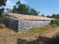
(4) Take this path to the left for a few dozen metres to reach a restored sheepfold. Return to this path via the same route. Turn left to begin an easy climb ending at Col de Saint-Valentin.

(5) Continue downhill opposite to reach thefirst crossroads you passed on the way there.
Take the track opposite downhill.

(1) Turn left and follow the same route as on the way up to return to the La Garussière car park (S/E).


Waypoints

  1. S/E : mi 0 - alt. 3,038 ft - La Garussière car park
  2. 1 : mi 0.55 - alt. 3,219 ft - Crossroads of the circular loop
  3. 2 : mi 1.7 - alt. 3,527 ft - Return to the trail
  4. 3 : mi 1.97 - alt. 3,435 ft - Turn right before the house.
  5. 4 : mi 3.2 - alt. 3,274 ft - Collet de Mire
  6. 5 : mi 3.7 - alt. 3,435 ft - Col de Saint Valentin
  7. S/E : mi 4.59 - alt. 3,035 ft - La Garussière car park

Notes

There are no drinking water points along the route.
(5) You can take shelter in the old sheepfold if necessary.

Worth a visit

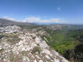
(5) Col Saint-Valentin: you can climb to the summit of Mont Saint-Valentin, which offers a beautiful view of the Mercantour peaks and the Mediterranean. This climb is not difficult, even though there is no path.
This adds about 1 km to the walk, with an additional 60 m elevation gain.
You can visit Vence and Saint-Paul-de-Vence (with the Maeght Foundation) located a few kilometres towards Nice.

Reviews and comments

3.7 / 5
Based on 11 reviews

Reliability of the description
3.6 / 5
Ease of following the route
4.1 / 5
Route interest
3.4 / 5
Artdesmets
Artdesmets

Overall rating : 3.7 / 5

Date of your route : Jun 03, 2024
Reliability of the description : ★★★☆☆ Average
Ease of following the route : ★★★★☆ Good
Route interest : ★★★★☆ Good
Very busy route : No

A lovely hike at an altitude of around 1,000 metres, with a low elevation gain for the region, so it's not too tiring.

  1. The most beautiful spot, with a magnificent panorama, Mont St Valentin, is not part of the hike and is mentioned as an option only. It is not true that there is no path to get there: from point 5, follow a track and then a path up to the summit of the mountain. It takes about 15 minutes extra to climb up there. The path disappears about 50 metres from the summit, but it is very easy to continue as it is straight ahead and you can still see the summit. It should even be the title of this hike and the main goal. .
  2. The hike is pleasant as it passes through beautiful, varied and flower-filled countryside (magnificent thyme and flowering broom).
  3. The restored sheepfold is superb. You can enter through a door. Unfortunately, it is starting to deteriorate: the door is loose and the tiles are broken. It is surprising that there is no sign explaining who renovated it, for what purpose, when it was built, what the sheepfold is currently used for, etc.
  4. We encountered very few hikers, most of whom probably preferred the hike to the Vescagnes waterfall, which starts from the same car park but on the other side of the road.
  5. However, we did encounter dogs that were not on a leash, two of which were aggressive and even tried to bite us.
  6. It is not necessary to go through the valley after point 1, except to avoid the less shaded track. As it is off-limits (private property), it is better to stay on the track.
  7. It's a shame that there are no signs along the entire route, particularly for the sheepfold or the summit of St Valentin.

Machine-translated

Axl06
Axl06

Overall rating : 4 / 5

Date of your route : May 20, 2024
Reliability of the description : ★★★★★ Very good
Ease of following the route : ★★★★☆ Good
Route interest : ★★★☆☆ Average
Very busy route : No

The undergrowth provides some pleasant coolness when it is already hot.
The valley is indeed off-limits (sign).
We heard a cuckoo almost throughout the entire hike !
You can extend the hike slightly by going to the summit of St Valentin and enjoying a beautiful panorama.
In my opinion, the hike is very pleasant and enjoyable, without being "exceptional" (but that's already good!).

Machine-translated

hbarnoin
hbarnoin

Overall rating : 4 / 5

Date of your route : Nov 16, 2023
Reliability of the description : ★★★★☆ Good
Ease of following the route : ★★★★★ Very good
Route interest : ★★★☆☆ Average
Very busy route : No

Caution! It is forbidden to pass through the valley and follow the track.

Machine-translated

Coldom
Coldom

Overall rating : 3.7 / 5

Date of your route : Feb 21, 2022
Reliability of the description : ★★★☆☆ Average
Ease of following the route : ★★★★☆ Good
Route interest : ★★★★☆ Good
Very busy route : No

A very pleasant route in winter (more of a family walk than a hike). The description is not always very precise for someone without a GPS. For point 1 (crossroads), note that the path down to the right is the one you will take on the way back. Note that the path leading into Combe Moutonne is located below and to the left of the track. Point 3 is not in front of a house but a stable. There is an electric fence that you need to follow by taking the track through the woods on the right.
After the return trip to Mont St Valentin (not to be missed for the panoramic view), take the path on the left of the track immediately after the pass, which leads back to point 1.

Machine-translated

Pcours
Pcours

Overall rating : 4 / 5

Date of your route : Oct 24, 2020
Reliability of the description : ★★★★☆ Good
Ease of following the route : ★★★★☆ Good
Route interest : ★★★★☆ Good
Very busy route : No

A nice little walk.
We didn't take the combe (closed!) but stayed on the track.
Very beautiful sheepfold.

Machine-translated

JLOUISL
JLOUISL

Overall rating : 4.7 / 5

Date of your route : Aug 10, 2020
Reliability of the description : ★★★★★ Very good
Ease of following the route : ★★★★★ Very good
Route interest : ★★★★☆ Good
Very busy route : No

Easy and very beautiful hike.
Pleasant in summer as it is often shaded.

Machine-translated

Shinsei
Shinsei

Overall rating : 3.7 / 5

Date of your route : Jun 28, 2020
Reliability of the description : ★★★★☆ Good
Ease of following the route : ★★★★☆ Good
Route interest : ★★★☆☆ Average
Very busy route : No

Easy hike with little elevation gain, but the first trail to the valley was closed. Be sure to bring mosquito repellent, as there are many stagnant pools of water and therefore lots of mosquitoes on part of the route. This is not a route for viewing scenery, but it is a very pleasant walk through the woods.

Machine-translated

Les cop's
Les cop's

Overall rating : 4.3 / 5

Date of your route : Jun 26, 2020
Reliability of the description : ★★★★☆ Good
Ease of following the route : ★★★★★ Very good
Route interest : ★★★★☆ Good
Very busy route : No

A pleasant, shaded route that can be completed in a short time and presents no difficulty.
Not very busy route, on a Thursday, just a small group of six people.
Advantage: a circular route that is not long.
A route for inexperienced walkers.
I disagree with the previous review. I did the walk on 24 June 2020. It was very flowery, with a pleasant breeze. The route is suitable for beginners and for gently introducing non-walkers to hiking.
People return without feeling tired and discover pretty woodlands and beautiful landscapes.

Machine-translated

Kjou
Kjou

Overall rating : 3 / 5

Date of your route : Jun 24, 2020
Reliability of the description : ★★★☆☆ Average
Ease of following the route : ★★★★☆ Good
Route interest : ★★☆☆☆ Disappointing
Very busy route : No

A shaded walk, yes, but not all the time. However, in my opinion, the walk itself is of no interest. We took the walk in the middle of June, when the broom was in bloom, but here there was nothing... just a few small white flowers scattered here and there. Landscapes... nothing. We were stuck between two hills, often walking on stony tracks.
What a shame when we are only a few hundred metres from the Saint Barnabé plateau, so beautiful with its large grey rocks, unobstructed views, flowering broom, sheep grazing in the distance...

Machine-translated

golfejuan06
golfejuan06

Overall rating : 2.3 / 5

Date of your route : Jun 15, 2020
Reliability of the description : ★★☆☆☆ Disappointing
Ease of following the route : ★★☆☆☆ Disappointing
Route interest : ★★★☆☆ Average
Very busy route : No

The instructions are too brief!

Machine-translated

sylvain.v06@gmail.com

Overall rating : 3.3 / 5

Date of your route : May 31, 2020
Reliability of the description : ★★★☆☆ Average
Ease of following the route : ★★★★☆ Good
Route interest : ★★★☆☆ Average
Very busy route : Yes

A pleasant walk through the woods, mostly in the shade, which is nice during hot weather.
However, there are three points to note:
1) At the start of the hike, the instructions say, "(1) Leave the track and take the path that leads into Combe Moutonne, running parallel to the track." The problem is that at the entrance to the combe, there is a very clear sign prohibiting use of the small path through the combe because it is private property! So, you can't take the valley and are forced to fall back on the track, which is much less pleasant to walk on. Nevertheless, the point of arrival at point (2) remains the same.
2) Since a large part of the hike is on a track suitable for vehicles, you occasionally come across vehicles, which frankly spoils the "hiking" aspect of this route.
3) Despite the short climb at the start of the route, there aren't really any clear views.
Nevertheless, we still had a pleasant time with easy access and proximity to the French Riviera coastline.
There are some beautiful spots under the pine trees for a snack near point (3).

Machine-translated

Other walks in the area

For more walks, use our search engine .

The GPS track and description are the property of this route's author. Please do not copy them without permission.