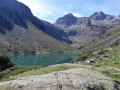
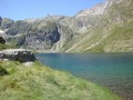
Lac d'Estom in the Lutour Valley

A beautiful hike in the Lutour Valley, which is a magnificent place.

Details

686767
Creation:
Last update:
Last review:
  • Walking
    Activity: Walking
  • ↔
    Distance: 6.70 mi
  • ◔
    Average duration: 4h 20 
  • ▲
    Difficulty: Moderate

  • ⚐
    Back to start: Yes
  • ↗
    Ascent: + 1,444 ft
  • ↘
    Descent: - 1,444 ft

  • ▲
    Highest point: 5,922 ft
  • ▼
    Lowest point: 4,478 ft

Photos

Description of the walk

Departure from La Fruitière, easily accessible from a road suitable for vehicles.

(S/E) Take the path at the end of the car park (signposted Lac d'Estom, 1 hour 45 minutes). Follow the path on the right bank of the stream, an easy, steady climb.

(1) Leave the path to the Russell Refuge on your left and continue straight ahead.

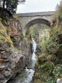
(2) Then cross the stream on the Pouey Caut footbridge and continue along the path. After 10 to 15 minutes, the climb becomes steeper. You will arrive at Lac d'Estom.

(3) Return to the car park (S/E) by following the same route you took on the way there.

Waypoints

  1. S/E : mi 0 - alt. 4,478 ft - Departure - La Fruitière
  2. 1 : mi 1.92 - alt. 5,066 ft - Intersection with Russell Trail
  3. 2 : mi 2.13 - alt. 5,095 ft - Footbridge
  4. 3 : mi 3.32 - alt. 5,919 ft - Refuge d'Estom
  5. S/E : mi 6.7 - alt. 4,478 ft - Arrival - La Fruitière

Notes

Refuge at Lac d'Estom with water source.
The estimated time (1 hour 45 minutes) is optimistic if you take the hike at a leisurely pace.

Reviews and comments

4.9 / 5
Based on 78 reviews

Reliability of the description
4.9 / 5
Ease of following the route
5 / 5
Route interest
4.9 / 5
Laplante cedric
Laplante cedric

Overall rating : 5 / 5

Date of your route : Sep 07, 2026
Reliability of the description : ★★★★★ Very good
Ease of following the route : ★★★★★ Very good
Route interest : ★★★★★ Very good
Very busy route : Yes

A lovely walk
Wildlife and a stream running alongside the whole way
A lovely final climb up to the lake
In short, absolutely lovely 👍

Machine-translated

User 21152392

Overall rating : 5 / 5

Date of your route : Aug 07, 2026
Reliability of the description : ★★★★★ Very good
Ease of following the route : ★★★★★ Very good
Route interest : ★★★★★ Very good
Very busy route : Yes

Hello.
To go on this walk, you need to be reasonably fit and have good walking shoes.
You should set off from Bonheur in the morning so you can take your time and enjoy the scenery.
Dogs are allowed on a lead. There are streams along the way where they can drink, but do bring two one-litre bottles just in case.
The app works very well; even without a 4G or 5G connection, the GPS tracks your progress very accurately.
Get your crampons ready.

Machine-translated

User 8539837

Overall rating : 5 / 5

Date of your route : Jul 26, 2026
Reliability of the description : ★★★★★ Very good
Ease of following the route : ★★★★★ Very good
Route interest : ★★★★★ Very good
Very busy route : Yes

A superb hike, which gets more challenging as you approach the lake.
With the wildlife, the torrent and the view of the mountains and the lake on arrival, it’s a real treat.
Quite a few people but not too many, relatively mild weather – in short, definitely worth doing!

Machine-translated

tinoambre
tinoambre

Overall rating : 5 / 5

Date of your route : Jul 20, 2026
Reliability of the description : ★★★★★ Very good
Ease of following the route : ★★★★★ Very good
Route interest : ★★★★★ Very good
Very busy route : Yes

A brilliant, fairly easy walk with stunning scenery all the way to the lake.
We also walked all the way round the lake, even though the path wasn’t always clear.
There are a few tricky sections over large rocks to watch out for, and the crossing at the far end of the lake can be tricky depending on the water level, but the view is brilliant.

Machine-translated

Thermox
Thermox

Overall rating : 4.7 / 5

Date of your route : Jul 19, 2026
Reliability of the description : ★★★★★ Very good
Ease of following the route : ★★★★☆ Good
Route interest : ★★★★★ Very good
Very busy route : No

A superb walk – you can spot horses and even chamois.

Machine-translated

User 23225843

Overall rating : 5 / 5

Date of your route : Jul 13, 2026
Reliability of the description : ★★★★★ Very good
Ease of following the route : ★★★★★ Very good
Route interest : ★★★★★ Very good
Very busy route : Yes

A lovely walk with no particular difficulties.

Machine-translated

User 4368670

Overall rating : 5 / 5

Date of your route : Jul 10, 2026
Reliability of the description : ★★★★★ Very good
Ease of following the route : ★★★★★ Very good
Route interest : ★★★★★ Very good
Very busy route : No

A magnificent valley in the Pyrenees with unspoilt natural beauty. A lovely walk.

Machine-translated

Arnaud Nabet
Arnaud Nabet
• Edited:

Overall rating : 5 / 5

Date of your route : Jul 08, 2026
Reliability of the description : ★★★★★ Very good
Ease of following the route : ★★★★★ Very good
Route interest : ★★★★★ Very good
Very busy route : Yes

A magnificent hike; the scenery is wonderful from start to finish.
It’s a fairly easy walk; there weren’t many people when we set off at 7.30 am, but there were more walkers later on. You need to choose the right time of day, but I’d recommend it for families or for introducing people to the mountains – it’s that beautiful.

Machine-translated

User 29158898

Overall rating : 5 / 5

Date of your route : Jun 24, 2026
Reliability of the description : ★★★★★ Very good
Ease of following the route : ★★★★★ Very good
Route interest : ★★★★★ Very good
Very busy route : Yes

Far too many people – because of a power cut, the chairlifts were out of service, and on top of that it was very hot, but the right-hand side is full of stones.
Otherwise, a good hike.

Machine-translated

Piot39
Piot39

Overall rating : 5 / 5

Date of your route : Jun 12, 2026
Reliability of the description : ★★★★★ Very good
Ease of following the route : ★★★★★ Very good
Route interest : ★★★★★ Very good
Very busy route : Yes

After Lake Ilhéou the day before, I enjoyed this walk even more. The path is much more scenic. Woods, a mountain stream, a waterfall and lovely vegetation. Still no animals? Just the whistling of marmots. Quite a few people about, but it’s fine. The road up to La Fruitière is really lovely, and the view from the car park already makes you want to set off on the walk!

Machine-translated

User 9890494

Overall rating : 5 / 5

Date of your route : May 31, 2026
Reliability of the description : ★★★★★ Very good
Ease of following the route : ★★★★★ Very good
Route interest : ★★★★★ Very good
Very busy route : Yes

The route to the dairy is already stunning!
A superb, gentle climb up to the lake; naturally, carry on to the waterfall at the far end, although access to it can be hit and miss depending on the erosion.
Magnificent, and… very, very busy over the Whitsun weekend…

Machine-translated

User 19628220

Overall rating : 5 / 5

Date of your route : Sep 15, 2025
Reliability of the description : ★★★★★ Very good
Ease of following the route : ★★★★★ Very good
Route interest : ★★★★★ Very good
Very busy route : Yes

A magnificent hike that was really enjoyable throughout, with beautiful panoramic views. The arrival at the lake is magnificent

Machine-translated

User 16932539

Overall rating : 5 / 5

Date of your route : Aug 18, 2025
Reliability of the description : ★★★★★ Very good
Ease of following the route : ★★★★★ Very good
Route interest : ★★★★★ Very good
Very busy route : Yes

An easy hike, even for seniors like us (aged 77). No particular difficulties, except for temperatures above 30°C at midday on 16 August at the lake.
As you get older, the stones on the moraine seem to get higher and higher.
The estimated climbing time (1 hour 45 minutes) is a little optimistic. Allow 2 to 2½ hours.
Enjoy the hike.

Machine-translated

nat56
nat56

Overall rating : 5 / 5

Date of your route : Aug 03, 2025
Reliability of the description : ★★★★★ Very good
Ease of following the route : ★★★★★ Very good
Route interest : ★★★★★ Very good
Very busy route : Yes

There weren't many people at the start at 8:30 a.m. The first part was easy along the water, with a few difficulties at the end, but nothing insurmountable, and we arrived at the lake with a magnificent view of the surrounding mountains and cliffs... There were more people on the way back, and in 10 years of hiking, I've never seen as many dogs as on this hike (we came across at least 20), even though I thought we were in the national park...

Machine-translated

User 9456811

Overall rating : 5 / 5

Date of your route : Aug 05, 2025
Reliability of the description : ★★★★★ Very good
Ease of following the route : ★★★★★ Very good
Route interest : ★★★★★ Very good
Very busy route : Yes

A beautiful hike where you come across numerous waterfalls. A popular route in summer.
Pretty lake but not much flat ground around the edge.

Machine-translated

Other walks in the area

For more walks, use our search engine .

The GPS track and description are the property of this route's author. Please do not copy them without permission.