Circular route from the Étang des Moines, starting from Kœur

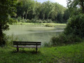
A route through the Kœur State Forest, which takes in a little gem: the Étang des Moines, right in the heart of the forest. This route can also be easily completed on foot.

Details

11864986
Creation:
Last update:
Last review:
  • Mountain biking
    Activity: Mountain biking
  • ↔
    Distance: 7.84 mi
  • ◔
    Duration according to the author: 2 hrs 
  • ▲
    Difficulty: Moderate

  • ⚐
    Back to start: Yes
  • ↗
    Ascent: + 423 ft
  • ↘
    Descent: - 423 ft

  • ▲
    Highest point: 1,168 ft
  • ▼
    Lowest point: 738 ft
  • ⚐ Country: France
  • ⚐ City: Kœur-la-Grande (55300)
  • ⚑
    Start/End: N 48.857751° / E 5.481719°
  • ❏
    IGN map(s): Ref. 3114SB

  • ◶
    Type of surface: Not specified
  • ⇧
    Bike carrying: Not specified
  • ▲
    Difficulty: Moderate
  • Hour-by-hour weather

Photos

Description of the route

Start from the car park at the foot of the church at Kœur-la-Grande.

(S/E) Take the D7 towards Pierrefitte. Ignore the road on the left towards Baudrémont (D71) and join the dirt track 150 metres further on, on the left.

(1) Follow this track and, at the three-way junction ahead, turn right. Continue along the track with the edge of the woodland on your left; then, after a wide bend to the left, begin the climb up the valley.

(2) Pass close to the springs that supply the village of Kœur-la-Grande and continue the climb at the bottom of the valley.

(3) At the top of the climb, you’ll cross another white path. Turn left, then immediately right. Follow this grassy path through the woodland in a straight line until you reach a fork with another white path.

(4) Carry on to the right. At the next junction (turning area), head diagonally right onto the white track and follow it to a T-junction.

(5) Turn right and carry on for about 600 m until you spot the sign for the Étang des Moines on a tree on your right.

(6) Turn right and carefully make your way down through the woodland towards the pond.

(7) Caution! There is a barely visible barrier across the path. Carry on for a few more metres.

(8) Once you reach the Étang des Moines, enjoy this haven of peace, a paradise for insects and waterbirds.
Walk along the embankment and, immediately afterwards, go down the wooden steps, then continue along the path through the woodland
which soon turns into a dirt track.

(9) Follow this path until you reach the road (D7).

(10) Turn right and head for the church at Kœur-la-Grande (S/E).

Waypoints

  1. S/E : mi 0 - alt. 745 ft - Car park at the - Eglise de Koeur la Grande
  2. 1 : mi 0.43 - alt. 738 ft - Path on the left
  3. 2 : mi 2.13 - alt. 1,001 ft - Springs in the village of Kœur-la-Grande
  4. 3 : mi 2.52 - alt. 1,155 ft - Turn left at the top of the hill
  5. 4 : mi 3.32 - alt. 1,122 ft - Path, on the right
  6. 5 : mi 4.36 - alt. 922 ft - Junction, turn right
  7. 6 : mi 4.72 - alt. 922 ft - Turn right at the sign
  8. 7 : mi 4.81 - alt. 892 ft - CAUTION: the barrier is difficult to see!!!
  9. 8 : mi 4.88 - alt. 879 ft - Étang des Moines
  10. 9 : mi 5.15 - alt. 876 ft - White path
  11. 10 : mi 6.19 - alt. 791 ft - D7, on the right
  12. S/E : mi 7.84 - alt. 745 ft - Car park at the - Eglise de Koeur la Grande

Worth a visit

When you set off (or on your return), do visit the beautiful church at Kœur-la-Grande, decorated with a Donzelli fresco.
It is not always open. To arrange for it to be opened and for a guide to accompany you, you will find the contact telephone numbers on the information board for the church, located on the wall of the car park.

Reviews and comments

4.7 / 5
Based on 2 reviews

Reliability of the description
4.5 / 5
Ease of following the route
5 / 5
Route interest
4.5 / 5
User 25965728

Overall rating : 4.3 / 5

Date of your route : Jun 02, 2025
Reliability of the description : ★★★★☆ Good
Ease of following the route : ★★★★★ Very good
Route interest : ★★★★☆ Good
Very busy route : Yes

A lovely walk, though there isn’t much shade for the first few kilometres. And it’s a shame that the last 3 kilometres are along the road.

Machine-translated

Sugar baby love
Sugar baby love

Overall rating : 5 / 5

Date of your route : Aug 12, 2024
Reliability of the description : ★★★★★ Very good
Ease of following the route : ★★★★★ Very good
Route interest : ★★★★★ Very good
Very busy route : No

A pleasant walk, plenty of shade.
A slight downside: the last half-hour of the walk was along the main road, which was a shame as there’s a lot of traffic.

Machine-translated

For more walks, use our search engine .

The GPS track and description are the property of this route's author. Please do not copy them without permission.