Between the lakes of Chambly and Chalain

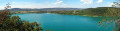
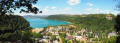
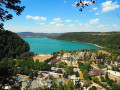
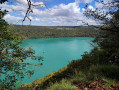
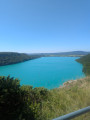
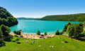
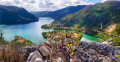
Lake Chalain, nestled in a valley flanked by high cliffs, is the largest in the Jura. After a walk through rural valleys offering beautiful views of Lake Chambly and the Jura mountains, you will walk along the cliffs overlooking its turquoise waters.

Details

25558404
Creation:
Last update:
Last review:
  • Walking
    Activity: Walking
  • ↔
    Distance: 6.60 mi
  • ◔
    Average duration: 3h 40 
  • ▲
    Difficulty: Moderate

  • ⚐
    Back to start: Yes
  • ↗
    Ascent: + 679 ft
  • ↘
    Descent: - 679 ft

  • ▲
    Highest point: 2,100 ft
  • ▼
    Lowest point: 1,729 ft

Photos

Description of the walk

Parking in Doucier, on the road to Chalain, in one of the car parks on the left. Yellow and white-red markings in places.

(S/E) Cross the road and head left, passing in front of ‘La Ruche du Lac’, carefully keeping to the side of the road, which is very busy during the summer. Turn right onto the stony path (MTB marker 119) which branches off immediately. Continue straight on along the left-hand track until the next junction (water tower marker).

(1) Turn sharp right onto the grassy path for a short climb to the viewpoint 300 m away at the far end of the lake.

(2) Return to the junction.

(1) Head up to the right, towards “Sur le Château”. Walk past the water tower. You’ll soon come to a T-junction; continue straight on to reach the D39.

(3) Cross it and continue left until you reach the edge of the woods, about a hundred metres further on. Two options:

  • follow the hiking signs, which unfortunately run alongside the D39 for 700 m. Turn right at the first fork. Then keep right onto the stony path.
  • At the edge of the woods, turn immediately right onto the stony path, which ends shortly afterwards. Continue straight on along the boundary between the two plots to rejoin the route at a right-angle bend in the stony path. This section is marked on the map, but I’m not sure if it’s on public land. Please respect the crops.

The path soon turns sharply right.

(4) When it turns left again, either:

  • you continue along the stony path.
  • climb up into the pasture for a circular route (opening and closing the gates and keeping an eye out for livestock, if any) for a lovely view of Lake Chambly and the Jura mountains.

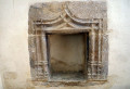
Then ignore a path climbing up to the right and continue straight on until you come within sight of the village of Songeson. Climb up to the left to the church. Note its flat stone roof (lauze). Behind the church, there is a picnic table. Inside, there are two old polychrome wooden statues and some beautifully carved niches.

(5) On leaving the village, head up to the right along the Chemin de la Barette. At the last house, continue straight on along the path that cuts across the bend. Then turn left onto the stony path and enter the woods. At the nearby clearing, continue straight on at the crossroads. You will soon spot in the rock the ruts left by the iron-rimmed wheels of our old carts.

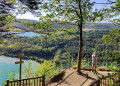
(6) Cross the main road and continue along the road opposite, towards “Vers le Château”. When it bends to the left, follow the path to the nearby viewpoint overlooking the far end of the lake and the leisure centre framed by the rocks of the valley.

(7) Set off again along the ledge path on the right, towards “La Frate”. Soon leave the path that descends to the right, staying on this track until you reach the Belvédère de la Frate.

(8) You cross a karst landscape and come to a fork. Continue straight ahead (right-hand path) along the ledge to the final viewpoint on the Roche. Be careful, as it is easy to miss it.

(9) After the viewpoint, the path widens, descending to the left and joining a crossroads. Take the first path leading down to your right towards a new junction marked by the sign ‘Place à Bois’. Turn left towards Doucier to reach a large open gravel area. Head straight down the lovely stony path which joins the first fork you passed on the way out.

(1) Continue straight ahead and return to the car park. (S/E)

Waypoints

  1. S/E : mi 0 - alt. 1,729 ft - Doucier
  2. 1 : mi 0.38 - alt. 1,841 ft - Access to the Doucier viewpoint
  3. 2 : mi 0.54 - alt. 1,932 ft - Doucier viewpoint
  4. 3 : mi 1.16 - alt. 1,916 ft - En Plain Palais
  5. 4 : mi 1.76 - alt. 1,923 ft - Lac de Chambly
  6. 5 : mi 2.94 - alt. 2,008 ft - Église Saint-Georges (Songeson)
  7. 6 : mi 3.97 - alt. 1,919 ft - Crossing the D 90 - Belvédère du Lac de Chalain
  8. 7 : mi 4.12 - alt. 1,923 ft - Junction. Return to the viewpoint
  9. 8 : mi 4.59 - alt. 1,936 ft - La Frate viewpoint
  10. 9 : mi 5.62 - alt. 1,936 ft - Sur la Roche Viewpoint
  11. S/E : mi 6.6 - alt. 1,729 ft - Doucier

Notes

The route includes ledge paths and unsecured viewpoints. Narrow paths along the edge of cliffs, rocky and slippery in places.

Wearing suitable footwear and using walking poles is recommended.

(3) and (4) Crossing fields and pastures: according to information gathered in the village, farmers seem to be tolerant of walkers. But to avoid any problems: avoid doing this walk when the grass is tall. Make sure you close the gates properly, or use the official marked paths from (3) to (4) and after (4).

Reviews and comments

4.2 / 5
Based on 6 reviews

Reliability of the description
4.3 / 5
Ease of following the route
4 / 5
Route interest
4.3 / 5
MINOMICHEL
MINOMICHEL

Overall rating : 4.3 / 5

Date of your route : Mar 09, 2026
Reliability of the description : ★★★★★ Very good
Ease of following the route : ★★★★☆ Good
Route interest : ★★★★☆ Good
Very busy route : No

A lovely little walk in the countryside with no difficulty, a table for meals in the village of Songeson and beautiful views of Lake Chalain.

Machine-translated

joel21
joel21

Overall rating : 4.3 / 5

Date of your route : Aug 25, 2025
Reliability of the description : ★★★★★ Very good
Ease of following the route : ★★★★☆ Good
Route interest : ★★★★☆ Good
Very busy route : No

A pleasant short hike...

Machine-translated

carinec21
carinec21

Overall rating : 4.3 / 5

Date of your route : Sep 19, 2024
Reliability of the description : ★★★★☆ Good
Ease of following the route : ★★★★☆ Good
Route interest : ★★★★★ Very good
Very busy route : No

A really lovely walk, with no major difficulties; for me, the best bit was the final stretch overlooking the lake, with various vantage points. Very pleasant.

Machine-translated

christian69390
christian69390

Overall rating : 2.7 / 5

Date of your route : Sep 22, 2022
Reliability of the description : ★★☆☆☆ Disappointing
Ease of following the route : ★★☆☆☆ Disappointing
Route interest : ★★★★☆ Good
Very busy route : No

It’s not easy to find your way… but it’s still a lovely walk with some very pretty viewpoints (unsecured)
The return journey along the lake is superb

Machine-translated

thierry.veyziat
thierry.veyziat
• Edited:

Overall rating : 5 / 5

Date of your route : Sep 22, 2022
Reliability of the description : ★★★★★ Very good
Ease of following the route : ★★★★★ Very good
Route interest : ★★★★★ Very good
Very busy route : No

Hello,
Thank you for sharing this lovely walk between the lakes.
A lovely route with beautiful views, sections through the woods and a lovely mix of both.

Machine-translated

Socié Claude
Socié Claude

Overall rating : 4.7 / 5

Date of your route : Sep 11, 2022
Reliability of the description : ★★★★★ Very good
Ease of following the route : ★★★★★ Very good
Route interest : ★★★★☆ Good
Very busy route : No

A lovely walk on this wonderful early autumn day; stunning views, no strenuous climbs, and a sense of peace and quiet; lovely photos of the lakes with their delicate colours

Machine-translated

Other walks in the area

For more walks, use our search engine .

The GPS track and description are the property of this route's author. Please do not copy them without permission.