From Valbonë to Theth

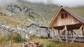
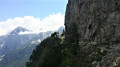
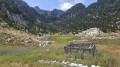
Route between Valbonë (Valbone) and Theth in Albania. A magnificent route that follows the Balkan Trail. The path is stony at the start in the riverbed but then becomes quite shaded. There are beautiful viewpoints all along the route and water at regular intervals to cool off, as well as a magnificent 360° view at the summit

Details

100840226
Creation:
Last update:
Last review:
  • Walking
    Activity: Walking
  • ↔
    Distance: 9.53 mi
  • ◔
    Average duration: 7h 05 
  • ▲
    Difficulty: Moderate

  • ⚐
    Back to start: No
  • ↗
    Ascent: + 3,120 ft
  • ↘
    Descent: - 4,045 ft

  • ▲
    Highest point: 6,083 ft
  • ▼
    Lowest point: 2,362 ft

Description of the walk

The start is about 3 km past the village of Valbonë. Altitude: approximately 1,000 metres. Make sure you pack enough food for the walk before you set off, as there isn’t much to buy to eat in the village.

Our host drove us to the start point at the end of the tarmac road.

There’s about 4 km of gently sloping, slightly uphill terrain following a dry riverbed, and then the climb begins.

On reaching the Valbonë Pass, if you fancy a further climb, you can do a round trip to the summit at 1,909 metres.

Back at the Valbonë Pass, we began the descent to Theth.

As for me, my route ends at my hotel, situated on the outskirts of Theth at an altitude of 720 metres.

You can’t go wrong on this route; it’s very well signposted in red and white.

The hike can be done in either direction without any problems.

It’s a challenging route as the descent before reaching Theth is quite steep, but it’s such an exceptional experience that you quickly forget the effort involved.

Waypoints

  1. S : mi 0 - alt. 3,287 ft - Car park
  2. 1 : mi 2.16 - alt. 3,747 ft - Rragam
  3. 2 : mi 4.49 - alt. 5,896 ft - Valbonë Pass
  4. 3 : mi 4.77 - alt. 6,060 ft - Summit
  5. 4 : mi 8.89 - alt. 2,454 ft - Theth (Thethi)
  6. E : mi 9.53 - alt. 2,379 ft - Bujtina Miqesia - Kisha e Thethit (Église de Theth)

Worth a visit

Theth Church

Other walks in the area

For more walks, use our search engine .

The GPS track and description are the property of this route's author. Please do not copy them without permission.