From Aghia Roumeli (Αγια Ρουμελη) to Loutro (Λουτρό)

A hike that starts at the bottom of the Samaria Gorge in Agia Roumeli. There are opportunities for a swim at the start of the route and at Agios Pavlos (3 km in), then at 13 km, at the end, at Marmara and Loutro.

Details

55418155
Creation:
Last update:
Last review:
  • Walking
    Activity: Walking
  • ↔
    Distance: 9.13 mi
  • ◔
    Average duration: 5h 50 
  • ▲
    Difficulty: Moderate

  • ⚐
    Back to start: No
  • ↗
    Ascent: + 1,890 ft
  • ↘
    Descent: - 1,880 ft

  • ▲
    Highest point: 404 ft
  • ▼
    Lowest point: -3 ft
  • ⚐ Country: Greece
  • ⚑
    Start: N 35.229696° / E 23.960608°
  • ⚑
    End: N 35.198368° / E 24.079226°
  • Hour-by-hour weather

Photos

Description of the walk

The walk starts from the village of Aghia Roumeli.

The E4 trail is marked in black and yellow by posts or painted signs (in some places with red dots)

(S) Head eastwards, towards the “campsite”.

(1) A sign showing the route of the E4 walk (to sound ‘local’, say ‘Epsilon tesserra’!) indicates the path to follow. Cross a small bridge over the river, which flows from the Samaria Gorge, then head up towards a small sheepfold. Don’t forget to close the gate behind you.
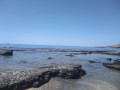
The path runs alongside the beach; stick to the upper part of the beach rather than the pebbly section to spot the markings that help you navigate the slightly trickier sections. Avoid walking through the sea!
You’ll reach Aghios Pavloσ (Αγιος Παύλος), with its little chapel and guesthouse, after about 1½ hours.

(2) Continue uphill towards the wooded area. The path continues under the trees and reaches a fork.

(3) Ignore the path leading uphill to Aghios Ioannis (Αγιος Ιωάννης) and carry on straight ahead towards Loutro (Λουτρό).
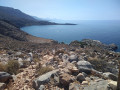
The shaded section ends; continue along a much rockier stretch overlooking the beach for about two hours’ walk, before descending to Marmara (Μαρμαρά) beach, situated at the exit of the Aradena Gorge (Αράδαινα).

(4) Continue by climbing up onto a small plateau, still skirting the sea, then, via a tricky descent, reach the beach. Look out for the red markings on the rocks to find the path.

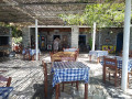
(5) Walk along the beach and pass the shaded terrace of a tavern (the E4 sign is clearly visible). This is also a good opportunity to take a break.

(6) Take the steps and walk past the houses to the gate – be sure to close it behind you – then take the road that climbs up to the hairpin bend on the left.

(7) Leave the road and take the stony path leading uphill to the right. You’ll see a gate at the top; go through it and head down towards Finika (Φοινικα). A large gate closes off this part of the bay, which appears to be private, but access is permitted as the gate is not locked. Walk past the small beach and you’ll come to a fork in the path.

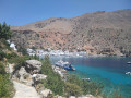
(8) Carry on to the right and you’ll reach the magnificent bay of Loutro (E).

Waypoints

  1. S : mi 0 - alt. 30 ft - The village of Aghia Roumeli
  2. 1 : mi 0.14 - alt. 30 ft - Signpost for the route
  3. 2 : mi 2.47 - alt. 30 ft - Agios Pavlos
  4. 3 : mi 3.3 - alt. 203 ft - T-junction, Loutro/Agios Loannis
  5. 4 : mi 6.91 - alt. 23 ft - Entrance to the Aradena Gorge/Marmara Beach
  6. 5 : mi 7.4 - alt. 43 ft - Beach
  7. 6 : mi 7.6 - alt. 23 ft - Nikosia Restaurant
  8. 7 : mi 7.79 - alt. 157 ft - Stony path on the right
  9. 8 : mi 8.21 - alt. 3 ft - T-junction: “Loutro at 700 m or 1,300 m”
  10. E : mi 9.13 - alt. 23 ft - Loutro

Notes

(8) You can follow the sign for “Loutro, 700 m”, passing via the summit.

(E) Plenty of bars and restaurants.

I did this walk at the end of June and set off at 6 am as there is little or no shade along the route; make sure you take plenty of water. Allow between 5 and 5.5 hours for the walk, taking your time.

Depending on the time of year, it’s best to set off early as there is no shade. You can return by boat (1.20 pm – 4.50 pm); the fare is €13.80 in June 2024.
You can also continue on to Chora Sfakion (Χώρα Σφακίων); allow an extra two hours.
This hike can also be done starting from Paleochora (Παλαιόχωρα), travelling there by boat in the morning (7.00 am, Thursday to Sunday, arriving at Aghia Roumeli at 8.00 am).

Reviews and comments

4.5 / 5
Based on 2 reviews

Reliability of the description
5 / 5
Ease of following the route
4 / 5
Route interest
4.5 / 5
ChristianNo
ChristianNo

Overall rating : 4.7 / 5

Date of your route : May 11, 2025
Reliability of the description : ★★★★★ Very good
Ease of following the route : ★★★★☆ Good
Route interest : ★★★★★ Very good
Very busy route : No

A hike on 11 May during a heatwave in Crete: 30 degrees.
Mountains plunging into turquoise waters: such is the stunning scenery.
The sandy or gravelly start makes for a rather difficult walk, but you soon find the shade of the forest for about 6 km.
The succession of ascents and descents (a total elevation gain of about 400 metres, not 570) proved tiring in the intense heat, and Marmara Beach provided a welcome opportunity for a swim
before tackling the final stretch, which requires careful attention.
The arrival in Loutro is quite magical.
Avoid wearing trainers as the ground is stony or rocky, and make sure you take plenty of water and a good hat.

Machine-translated

jeanmariebrusq
jeanmariebrusq

Overall rating : 4.3 / 5

Date of your route : Oct 08, 2024
Reliability of the description : ★★★★★ Very good
Ease of following the route : ★★★★☆ Good
Route interest : ★★★★☆ Good
Very busy route : No

Hello, there aren’t many people on this well-described and well-signposted path. It’s lovely. There are one or two sections where you need to watch your step. The only real difficulty is the heat, even in October. There’s no shade, or very little. Make sure you bring sun cream and 2 litres of water per person (there’s no water before Marmara beach). Thank you for the description.

Machine-translated

Other walks in the area

For more walks, use our search engine .

The GPS track and description are the property of this route's author. Please do not copy them without permission.