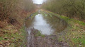
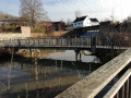
In the Bois de Baudour

A veritable green lung in the Borinage, the undivided Baudour State Forest is a little paradise for walkers – and probably for wildlife too! You’ll discover a wealth of biodiversity there. The walk takes a grand tour of the central section, situated between the N524 to the west and the Brussels–Mons railway line to the east. Towards the end, the route passes by the Ghlin railway halt and joins the Erbisœul halt via the Long-Distance Walk No. 129.
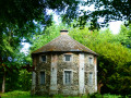
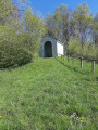
The two architectural highlights of the walk are the Ronde Maison and the Notre-Dame du Mouligneau chapel.

Details

103287449
Creation:
Last update:
Last review:
  • Walking
    Activity: Walking
  • ↔
    Distance: 9.41 mi
  • ◔
    Average duration: 4h 35 
  • ▲
    Difficulty: Moderate

  • ⚐
    Back to start: Yes
  • ↗
    Ascent: + 322 ft
  • ↘
    Descent: - 331 ft

  • ▲
    Highest point: 312 ft
  • ▼
    Lowest point: 151 ft

Photos

Description of the walk

(7) Anyone wishing to stay in the forest can turn left here and head back to the starting point more or less in a straight line.

(9) The route follows a short section of an old disused railway line. This section is marked as ‘under construction’ on OpenStreetMap (03-08-2026). This is not the case: there is no construction work in sight and no access restrictions. It is, however, poorly maintained but relatively well used.

Waypoints

  1. S/E : mi 0 - alt. 279 ft - Car park on Rue Montauban, Saint-Ghislain
  2. 1 : mi 0.09 - alt. 289 ft - La Ronde Maison
  3. 2 : mi 0.79 - alt. 272 ft - Duck ponds
  4. 3 : mi 1.06 - alt. 295 ft - The 6 Paths
  5. 4 : mi 2.31 - alt. 240 ft - The Baudour Spring
  6. 5 : mi 2.49 - alt. 223 ft - Rest area
  7. 6 : mi 3.07 - alt. 249 ft - Former Erbisœul–Saint-Ghislain railway line
  8. 7 : mi 4.71 - alt. 230 ft - Possible shortcut
  9. 8 : mi 5.73 - alt. 157 ft - Ghlin industrial estate
  10. 9 : mi 6.03 - alt. 167 ft - Former Ghlin–Saint-Ghislain railway line
  11. 10 : mi 6.4 - alt. 157 ft - Ghlin station
  12. 11 : mi 6.79 - alt. 161 ft - Notre-Dame du Mouligneau Chapel
  13. 12 : mi 8.37 - alt. 213 ft - Erbisœul station
  14. S/E : mi 9.41 - alt. 279 ft - Car park on Rue Montauban, Saint-Ghislain

Notes

Picnic tables at (S/E) and (5).
500 m in a commercial area between (8) and (9) and a few hundred metres along village streets near the railway stations at Ghlin (10) and Erbisœul (12).

Other walks in the area

For more walks, use our search engine .

The GPS track and description are the property of this route's author. Please do not copy them without permission.