


Refine your search for walks in Cuenca
Cuenca walks


 Source of the River Cuervo – Pico San Felipe
 Visorando Member

 7.02 mi
 +1,273 ft
 -1,270 ft
 4h 20
 Moderate
 Departure from Cuenca
An easy hike from the source of the Rio Cuervo (beautiful waterfalls, very, very popular) to the highest point of the massif, San Felipe (1,838 m), via its northern slope. It is a dome-shaped peak from which you can enjoy a stunning 360° panorama on a clear day.
It can be done on foot in all seasons as there is often shade, and even on snowshoes in winter.
The hike takes place within the Serrania de Cuenca Natural Park.
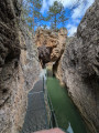
Calomarde Canyon
 3.94 mi
+486 ft
-469 ft
2h 15
 Easy
Departure from Albarracín (Teruel)
A beautiful hike along a superb canyon at the entrance to Calomarde. A fairly busy site in a very touristy area.Please note that when parking in the village of Colomarde, it is best to use the paid car park or find spaces in the village, although these are few and far between. If you do park in the village, please respect the area and its residents by parking correctly where possible.