Croix du Nivolet

A must-do hike for locals, this short trip to the Dent du Nivolet offers a beautiful 360° panorama of Lac du Bourget, Chartreuse, Belledonne, Beaufortain and Mont Blanc.

Details

90688
Creation:
Last update:
Last review:
  • Walking
    Activity: Walking
  • ↔
    Distance: 10.76 km
  • ◔
    Average duration: 5h 35 
  • ▲
    Difficulty: Moderate

  • ⚐
    Back to start: Yes
  • ↗
    Ascent: + 866 m
  • ↘
    Descent: - 865 m

  • ▲
    Highest point: 1,546 m
  • ▼
    Lowest point: 809 m

Photos

Description of the walk

(S) Depart from the car park at the end of the D8 in Pragondran.

(1) Take the road uphill on the right just after the car park and find an uphill track in the beech forest. In the Montbasin forest.

(2) At the end of the series of hairpin bends, take the track on the left which climbs towards Nivolet, signposted for 1 hour 40 minutes. Beautiful clearings offer views of the Chartreuse de Belledonne and Lac du Bourget mountains.

(3) Climb up an open slope and take the path on the right towards the Pas de l'Échelle. A handrail and a series of rungs and clamps have been installed to help you cross the Pas de l'Échelle gap and come out on the Mont Nivolet.

(4) At the crossroads of the Nivolet refuge, take the track with wide steps to reach the Croix du Nivolet viewpoint.

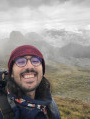
(5) This offers a 360° panorama. Pass the Nivolet refuge again and take the track on the left towards the Chalet du Sire.

(6) At the crossroads, leave the Féclaz direction on your right and continue towards the Chalet du Sire. Pass the paragliding take-off point (7) and continue downhill to the car park, which you cross to find the Croc passage (8) directly to the west.

Follow the stony track that winds downhill.

(9) Cross and leave the path that passes at the foot of the rocky ridge on your left.

(10) Join the track at Malpassant on the left and continue to the car park where you started.

Waypoints

  1. S/E : km 0 - alt. 809 m
  2. 1 : km 0.96 - alt. 921 m
  3. 2 : km 3.06 - alt. 1,335 m
  4. 3 : km 4.26 - alt. 1,516 m - Nivolet refuge.
  5. 4 : km 4.38 - alt. 1,546 m - CROIX DU NIVOLET
  6. 5 : km 5.17 - alt. 1,510 m
  7. 6 : km 6.75 - alt. 1,501 m - Paragliding take-off point.
  8. 7 : km 7.59 - alt. 1,410 m
  9. 8 : km 8.39 - alt. 1,144 m
  10. 9 : km 9.38 - alt. 964 m - Malpassant.
  11. S/E : km 10.76 - alt. 810 m

Notes

Be careful, as the markings are missing in some places.
Alternative route possible via the chimney.
The Pas de l'Échelle does not require any special equipment but may not be suitable for people who are prone to vertigo.

(3) At this crossroads, there is an alternative route via the Cheminée, continuing straight ahead towards the summit.

Reviews and comments

4.6 / 5
Based on 33 reviews

Reliability of the description
4.6 / 5
Ease of following the route
4.6 / 5
Route interest
4.7 / 5
jakes38
jakes38

Overall rating : 4.7 / 5

Date of your route : Nov 10, 2025
Reliability of the description : ★★★★★ Very good
Ease of following the route : ★★★★☆ Good
Route interest : ★★★★★ Very good
Very busy route : No

Climb up to the cross via a path that is steep in places and best tackled in dry weather, especially in autumn when there are leaves on the ground. Some steep sections require sure-footedness and a certain amount of experience on mountain trails. The ladder step and the sloping section with cables that precedes it require you to be comfortable in rocky terrain and not prone to vertigo.
A beautiful autumn hike with a superb view from the summit of the surrounding mountains, the valley and Lake Bourget.
The route is easy to follow.

Machine-translated

ExAL_87
ExAL_87

Overall rating : 4.3 / 5

Date of your route : Sep 29, 2025
Reliability of the description : ★★★★☆ Good
Ease of following the route : ★★★★★ Very good
Route interest : ★★★★☆ Good
Very busy route : No

A route mainly through forest, punctuated by beautiful views of the lake and a magnificent panorama at the Croix du Nivolet.
One section with ladders can be daunting and is not recommended for young children; it is better to choose another route to climb up to the cross. Other than that, there are no difficulties. Thank you for sharing.

Machine-translated

User 25605071

Overall rating : 4.7 / 5

Date of your route : Jul 06, 2025
Reliability of the description : ★★★★★ Very good
Ease of following the route : ★★★★★ Very good
Route interest : ★★★★☆ Good
Very busy route : No

Route completed on 1 July 2025, by two adults in good physical condition but not necessarily very experienced in alpine hiking with significant elevation gain. The elevation gain here is reasonable and mostly in the shade of the forest (very pleasant given the heatwave on this day!). There is one section that is quite technical for beginners, with a missing rung on a ladder, which makes it difficult for people of short stature (1.60 m was difficult, we had to use the rock on the side to fill the gap), but it is not insurmountable if you are physically fit and not too afraid of heights.
Very nice view at the cross, with no crowds that day and much more breathable temperatures!
A lovely route, which is a little more interesting on the way up than on the way back.

Machine-translated

yvesdesgeorges
yvesdesgeorges

Overall rating : 4.7 / 5

Date of your route : May 24, 2025
Reliability of the description : ★★★★★ Very good
Ease of following the route : ★★★★★ Very good
Route interest : ★★★★☆ Good
Very busy route : No

We went to the Orionde viewpoint, which offers a bird's eye view of Lake Bourget (4 km round trip)

Machine-translated

Mick01
Mick01

Overall rating : 4.3 / 5

Date of your route : Aug 19, 2023
Reliability of the description : ★★★★☆ Good
Ease of following the route : ★★★★☆ Good
Route interest : ★★★★★ Very good
Very busy route : No

We did this trail with two children (aged 7 and 11). There are just a few metres where you need to be careful, and there is a cable to hold on to just before you reach the bar, but it's nothing too difficult for people who are used to hiking in the mountains.
We returned along the edge of the cliff at Malpassant, where there are several viewpoints and paragliders take off, before returning to Pragondran.
The plateau between the cross and Le Sire is quite busy, but the climb and descent are deserted.

Machine-translated

toposrandos
toposrandos

Overall rating : 5 / 5

Date of your route : Jun 21, 2023
Reliability of the description : ★★★★★ Very good
Ease of following the route : ★★★★★ Very good
Route interest : ★★★★★ Very good
Very busy route : No

We reached the Croix de Nivolet by climbing up the stone chimney and we are delighted!
On the way back, before reaching Pragondran, we took the path that follows the cliff... it's well worth it!

Machine-translated

BUFFARD HERVE
BUFFARD HERVE

in preparation

Machine-translated

annievilliers
annievilliers

Overall rating : 4 / 5

Date of your route : Aug 29, 2022
Reliability of the description : ★★★★☆ Good
Ease of following the route : ★★★☆☆ Average
Route interest : ★★★★★ Very good
Very busy route : Yes

Some rungs are missing from the ladders in certain places, making the rocky sections difficult to navigate (especially for children).
Return via the Sire chalet. It would be interesting to try the hike in the opposite direction.

Machine-translated

courtelm
courtelm

Overall rating : 4.7 / 5

Date of your route : Aug 29, 2022
Reliability of the description : ★★★★★ Very good
Ease of following the route : ★★★★★ Very good
Route interest : ★★★★☆ Good
Very busy route : Yes

very easy route

Machine-translated

misspec
misspec

Overall rating : 4.7 / 5

Date of your route : Jun 21, 2022
Reliability of the description : ★★★★★ Very good
Ease of following the route : ★★★★☆ Good
Route interest : ★★★★★ Very good
Very busy route : Yes

A beautiful hike with stunning scenery and a lovely trail climbing up under the ladders. (Signposting needs to be improved in some built-up areas).:whist le:

Machine-translated

canu.odile@orange.fr

Overall rating : 5 / 5

Date of your route : Nov 20, 2021
Reliability of the description : ★★★★★ Very good
Ease of following the route : ★★★★★ Very good
Route interest : ★★★★★ Very good
Very busy route : No

A very pleasant hike with superb panoramic views of the peaks of various mountain ranges above a sea of clouds and under bright sunshine. The section between the Croix du Nivolet and the Col de Sire is busier than the section up to the Pas de l'Echelle.
Thanks to the author for this route description.

Machine-translated

MHalouin
MHalouin

Overall rating : 5 / 5

Date of your route : Jul 06, 2021
Reliability of the description : ★★★★★ Very good
Ease of following the route : ★★★★★ Very good
Route interest : ★★★★★ Very good
Very busy route : No

The view is always superb from the Croix du Nivolet. We climbed up the ladders and didn't meet anyone. The busiest parts are those climbing up from La Féclaz and towards the Chalet du Sire and, of course, at the summit at the Croix.
It was our first time climbing the ladders and, although we are "well past our prime", we had no difficulty, but we are used to hiking in the Savoie region.
Thank you to the Visorandonneurs who share their tracks and experiences.

Machine-translated

Pit59133
Pit59133

Overall rating : 5 / 5

Date of your route : May 30, 2021
Reliability of the description : ★★★★★ Very good
Ease of following the route : ★★★★★ Very good
Route interest : ★★★★★ Very good
Very busy route : No

Interesting, but at No. 3, after turning right and walking about a hundred metres, take a path that branches off to the left, which saves a few hundred metres and joins the higher path.
Passing the ladders and rungs with an 8-year-old child who is used to the mountains was no problem. On the way back, there is little point in following the map, as it is just a boring walk.
See the bread oven in the village of Pragondrand

Machine-translated

GFrando38
GFrando38

Overall rating : 4 / 5

Date of your route : Sep 05, 2020
Reliability of the description : Not used / Not applicable
Ease of following the route : ★★★★☆ Good
Route interest : ★★★★☆ Good
Very busy route : Yes

No one on the most difficult parts at the start and end
We climbed up the chimney to avoid the crowds on the ladders on a beautiful Saturday, but this climb must be classified as difficult and a little challenging
Superb view of Lake Bourget but crowded on the easy section between the Nivilet cross and the Col de Sire

Machine-translated

james6907
james6907

Overall rating : 5 / 5

Date of your route : Aug 21, 2020
Reliability of the description : ★★★★★ Very good
Ease of following the route : ★★★★★ Very good
Route interest : ★★★★★ Very good
Very busy route : No

Great hike starting from the Pragondran car park at 7 a.m
At this time of day, you will be alone on the climb and at the summit (arrival around 8.40 a.m.)
Avoid the ladders and cables if you have small children who are not used to them
Magnificent view from the summit
Very pleasant descent via the sire (chalet and water source available)
Be careful of slippery rocks if it has rained previously
I came across a mountain goat on the switchbacks leading to the car park on the way back
I highly recommend this hike in this direction
800 m elevation gain
3½ hours there and back, not fast

Machine-translated

Other walks in the area

For more walks, use our search engine .

The GPS track and description are the property of this route's author. Please do not copy them without permission.