Chemin du Bois du Sable

This route takes you on a tour of Old Cazaubon, its church, the Portes d’Uzan and du Hourrat, and the bullring. It starts at Lac de l’Uby and follows the old railway line, now known as the Marsan and Armagnac Greenway.

Details

383768
Creation:
Last update:
Last review:
  • Walking
    Activity: Walking
  • ↔
    Distance: 6.65 mi
  • ◔
    Average duration: 3h 20 
  • ▲
    Difficulty: Moderate

  • ⚐
    Back to start: Yes
  • ↗
    Ascent: + 282 ft
  • ↘
    Descent: - 282 ft

  • ▲
    Highest point: 486 ft
  • ▼
    Lowest point: 322 ft

Photos

Description of the walk

(S/E) From the Tourist Office, walk along the car park towards the Casino, pass the motorhome parking area, then turn left onto Boulevard Paul Daudé.

(1) Cross this boulevard and head for the steps. Follow the path to the next junction.

(2) At the junction, turn right and continue until you reach a road junction.

(3) Cross it, turn right, then left. Walk along the embankment.

(4) At the end of the embankment, turn left, then walk alongside Lac de l’Uby for 350 metres and take the first path on your right towards Rue Artigole. Continue until you reach the N524.

(5) Follow it to the right to reach the War Memorial. At the Y-junction, continue left until you reach the fire station.

(6) Turn left, then right towards the “Les Tournesols” nursery school. Pass by the water tower and continue towards Saint-Martin’s Church.

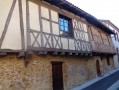
(7) At the half-timbered house, turn left to explore the Vieux Cazaubon neighbourhood via Rue de la Brêche.

(8) Turn right, head up towards the Porte du Hourrat and, at the end of the street, turn left. Turn left towards the bullring to reach Rue de Gascogne.

(9) Turn left, follow the D626 for over 1 km and cross the Pont de la Douze.

(10) Turn right to reach the old Cazaubon station. At the station, continue right along the Voie Verte for 4.5 km to reach the old Barbotan station.

(11) At the old station, head right towards the Trianon residential complex. Take Rue de l’Abbé Escarnot and follow it to Boulevard Paul Daudé until you reach the Tourist Office (S/E).

Waypoints

  1. S/E : mi 0 - alt. 381 ft - Car park at the Tourist Office
  2. 1 : mi 0.19 - alt. 397 ft - Crossing Boulevard Paul Daudé
  3. 2 : mi 0.36 - alt. 466 ft - Path junction
  4. 3 : mi 0.7 - alt. 394 ft - Junction with a road
  5. 4 : mi 1.14 - alt. 364 ft - End of the sea wall
  6. 5 : mi 1.66 - alt. 476 ft - Junction with the N524
  7. 6 : mi 2.12 - alt. 479 ft - Fire station
  8. 7 : mi 2.5 - alt. 463 ft - Half-timbered house
  9. 8 : mi 2.69 - alt. 427 ft - Rue de la Brèche
  10. 9 : mi 2.77 - alt. 423 ft - Turn left onto the D626
  11. 10 : mi 3.32 - alt. 322 ft - Towards the old Cazaubon railway station
  12. 11 : mi 5.92 - alt. 446 ft - The old Barbotan railway station
  13. S/E : mi 6.65 - alt. 381 ft - Car park at the Tourist Office

Notes

The route is quite long, so make sure you wear good walking shoes and take a bottle of water.
The route is fully signposted with yellow markers

Worth a visit

The 80-hectare Lake Uby.
Moutiques Castle.
The Old Cazaubon district.
Saint-Martin’s Church.
The wash house.
The bullring.
The old railway stations at Cazaubon and Barbotan-Les-Thermes.

Reviews and comments

3.8 / 5
Based on 3 reviews

Reliability of the description
3.7 / 5
Ease of following the route
3.7 / 5
Route interest
4 / 5
Benoît 62500
Benoît 62500

Overall rating : 3.3 / 5

Date of your route : Oct 24, 2022
Reliability of the description : ★★★☆☆ Average
Ease of following the route : ★★★★☆ Good
Route interest : ★★★☆☆ Average
Very busy route : No

We have changed the starting point so that the walk begins via the greenway; the section through Cazaubon is uninteresting, and a rather dangerous stretch running alongside the departmental road leads to Cazaubon.

Machine-translated

Alida.simone
Alida.simone

Overall rating : 4.3 / 5

Date of your route : Nov 06, 2021
Reliability of the description : ★★★★☆ Good
Ease of following the route : ★★★★☆ Good
Route interest : ★★★★★ Very good
Very busy route : No

The old Cazaubon is well worth a visit; it isn’t visible at all from the main road.

Machine-translated

Marie-Jo Nebra
Marie-Jo Nebra

Overall rating : 3.7 / 5

Date of your route : Aug 09, 2020
Reliability of the description : ★★★★☆ Good
Ease of following the route : ★★★☆☆ Average
Route interest : ★★★★☆ Good
Very busy route : Yes

We set off at 7.30 am (in sweltering heat). There were plenty of shaded sections. We passed through Cazaubon and Barbotan-les-Thermes. We re-routed some of the sections across fields.

Machine-translated

Other walks in the area

For more walks, use our search engine .

The GPS track and description are the property of this route's author. Please do not copy them without permission.