


There are several benches and a few picnic tables along the route.
We chose to stop for lunch at the beautiful natural site located between km 12.5 and 13.
NB: Visorando places this walk in Belgium :-) It is ENTIRELY within the Netherlands


The Dutch province of Zuid-Limburg is ideal for hiking, offering an abundance of countryside and forests to explore in a wonderfully bucolic setting, and probably the highest elevation gain in the Netherlands, as the highest point is situated at the BE-DE-NL tripoint south of Vaals.
That said, this region bordering Belgian Limburg is also fruit-growing, albeit to a lesser extent, but you can still see a few orchards (cherry, apple and pear trees).
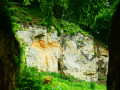
And then, from time to time, an old marl quarry (limestone, tuffeau, etc.) appears, or, as is the case near the route of this walk, a prehistoric flint extraction site!


 Country:
Belgium
Country:
Belgium


There are several benches and a few picnic tables along the route.
We chose to stop for lunch at the beautiful natural site located between km 12.5 and 13.
NB: Visorando places this walk in Belgium :-) It is ENTIRELY within the Netherlands
Fouron-le-Comte and the Altenbroek reserve from Gravenvoeren 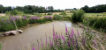 7.45 mi
+732 ft
-741 ft
4h 05
7.45 mi
+732 ft
-741 ft
4h 05
 Moderate
 Departure from Voeren (Province de Limbourg)
A short trip into the Netherlands near Mesch 3.03 mi
+148 ft
-148 ft
1h 30
Departure from Voeren (Province de Limbourg)
A short trip into the Netherlands near Mesch 3.03 mi
+148 ft
-148 ft
1h 30
 Easy
Departure from Voeren (Province de Limbourg)
Route de Lanaye via Montagne Saint-Pierre
Easy
Departure from Voeren (Province de Limbourg)
Route de Lanaye via Montagne Saint-Pierre  9.45 mi
+512 ft
-522 ft
4h 45
Moderate
Departure from Visé (Province de Liège)
A challenging visit to Montagne Saint-Pierre 4.84 mi
+348 ft
-364 ft
2h 30
Moderate
Departure from Visé (Province de Liège)
Montagne Saint-Pierre: the essentials!
9.45 mi
+512 ft
-522 ft
4h 45
Moderate
Departure from Visé (Province de Liège)
A challenging visit to Montagne Saint-Pierre 4.84 mi
+348 ft
-364 ft
2h 30
Moderate
Departure from Visé (Province de Liège)
Montagne Saint-Pierre: the essentials!  4.57 mi
+354 ft
-338 ft
2h 25
Easy
Departure from Visé (Province de Liège)
Berneau walk via Richelle and Dalhem 7.32 mi
+210 ft
-213 ft
3h 35
Moderate
Departure from Dalhem (Province de Liège)
From the Albert Canal to Montagne Saint-Pierre 8.80 mi
+659 ft
-650 ft
4h 35
Moderate
Departure from Riemst (Province de Limbourg)
Historical and cross-border route from Kanne
4.57 mi
+354 ft
-338 ft
2h 25
Easy
Departure from Visé (Province de Liège)
Berneau walk via Richelle and Dalhem 7.32 mi
+210 ft
-213 ft
3h 35
Moderate
Departure from Dalhem (Province de Liège)
From the Albert Canal to Montagne Saint-Pierre 8.80 mi
+659 ft
-650 ft
4h 35
Moderate
Departure from Riemst (Province de Limbourg)
Historical and cross-border route from Kanne  8.64 mi
+860 ft
-866 ft
4h 45
Moderate
Departure from Riemst (Province de Limbourg)
8.64 mi
+860 ft
-866 ft
4h 45
Moderate
Departure from Riemst (Province de Limbourg)
For more walks, use our search engine .
The GPS track and description are the property of this route's author. Please do not copy them without permission.
Scan this QR code with your smartphone's camera.
To open this route on your smartphone, you must have the Visorando app installed. If not, got to the Apple Store (iPhone) or Google Play Store (Android) to download the app.
 Visorando Member
