


otac baba

 Visorando Member
 Premium user
- Location: Grenoble (38000|38100)
- Gender: man
Sign up:
Published route(s)
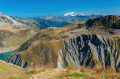
 Aiguillettes de Vaujany
 6.47 mi
 +3,924 ft
 -3,901 ft
 6h 25
 Difficult
 Departure from Vaujany (Isère)
A circular hike in a rather deserted area, with unique geological features alternating between steep high-altitude grasslands and a chaos of clay and black limestone needles.
Vaunoire – Combe Oursière Circular Loop
 5.78 mi
+4,242 ft
-4,249 ft
6h 20
Difficult
Departure from Lavaldens (Isère)
A superb circular walk in a corner of the countryside that’s still unspoilt. It allows you to admire the nearby Taillefer massif ‘from the bottom up’ and to enjoy the magnificent Vallon de Vaunoire, whilst avoiding the classic return route from Moulin Vieux.A few tricky sections add an extra bit of excitement to the route.The GPX track is essential for tackling this circular route.There is no path between the waypoints (2) and (6).