


missdolly

 Visorando Member
 Premium user
 Sign up:
Published route(s)
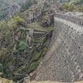
 Le Pas du Riot and Gouffre d'Enfer starting from Rochetaillée
 9.52 mi
 +1,732 ft
 -1,729 ft
 5h 55
5h 55
 Moderate
 Departure from Saint-Étienne (Loire)
A very beautiful, easy circular alternating between forest paths, magnificent landscapes and breathtaking views of the Château de Rochetaillée, the Roche Corbière (117 m high) and the Pas du Riot (1878) and Gouffre d'Enfer (1866) dams, whose surroundings have been converted into a very pleasant relaxation area for the end of this walk.
Route around Saint-Genis-les-Ollières
 6.21 mi
+427 ft
-456 ft
3h 15
Moderate
Departure from Craponne (Rhône)
6.21 mi
+427 ft
-456 ft
3h 15
Moderate
Departure from Craponne (Rhône)
A countryside hike on the outskirts of the city. An easy, almost flat route, ideal for family outings. It allows you to discover the Ratier, Méginand and Ribes streams. It offers some pretty views of the Monts du Lyonnais. It also features a "Jeux de regards" activity along the Ribes.
A short circular loop around Mont Pothu starting from Brullioles
5.11 mi
+902 ft
-879 ft
3h 10
Moderate
Departure from Brullioles (Rhône)
A lovely walk with beautiful views of Chamousset Castle, the Monts du Lyonnais, the Ain valley and the Alps in fine weather. The route offers a pleasant mix of mule tracks and forest paths.