


 Country:
 City:
City:


The access road to the car park is narrow. You can start the walk from the car park on the Bronte road.
Western slope of Mount Etna


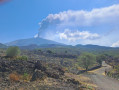
A route on the western slope of Mount Etna, an hour’s drive from Catania, following wide paths and mainly in the shade, crossing a lava flow. This route remains pleasant in summer as it is situated at high altitude and within the forest. It is possible to do this route by mountain bike. In the event of an eruption of Mount Etna (as was the case in August 2026), there will be no ash (the prevailing winds blow towards the south and east).
Details
Creation:
Last update:
Last review:
–
–
-
 Activity: Walking
 -
 Distance: 8.09 mi
 -
 Average duration: 4h 50
 -
 Difficulty: Moderate
 -
-
 Back to start: Yes
 -
 Ascent: + 1,234 ft
 -
 Descent: - 1,234 ft
 -
-
 Highest point: 4,423 ft
 -
 Lowest point: 3,438 ft
Photos
Waypoints
- S/E : mi 0 - alt. 3,438 ft - Car park
- 1 : mi 0.5 - alt. 3,625 ft - Junction
- 2 : mi 2.22 - alt. 3,802 ft - Entrance on the Bronte side
- 3 : mi 3.38 - alt. 4,131 ft - Viewpoint
- 4 : mi 5.32 - alt. 4,416 ft - Mountain hut
- S/E : mi 8.09 - alt. 3,438 ft - Car park
Notes
Other walks in the area
Etna via the south face
 Visorando Member8.19 mi
+3,724 ft
-3,737 ft
7h 00
Visorando Member8.19 mi
+3,724 ft
-3,737 ft
7h 00
 Very difficult
 Departure from Nicolosi (Catania)
Ascent of Etna, on its southern face, from the town of Nicolosi Nord. The departure point is at the foot of the cable car. The hike avoids the minibus route as much as possible.
Direct ascent to the cable car station. Then on to the first crater (accessible by minibus). Please note: from this point (1), a guide is mandatory.
The return journey was made via the same route (even though I could have taken alternative routes).
Ascent of the Montagnola crater
 5.12 mi
+2,851 ft
-2,838 ft
4h 50
5.12 mi
+2,851 ft
-2,838 ft
4h 50
 Difficult
Departure from Zafferana Etnea (Catania)
Difficult
Departure from Zafferana Etnea (Catania)
A very pleasant and varied hike in the Etna massif. The first section up to the ridge is an easy walk through typical vegetation, first through woodland and then through ‘high-altitude savannah’, with a beautiful view of the coast. From the ridge, there’s a splendid view of the Del Bove valley and Mount Etna. Then the steeper ascent along the ridge takes you into a whole new world. The vegetation gradually disappears, giving way to volcanic scoria.
The Seven Craters of Etna Walk
3.30 mi
+505 ft
-505 ft
1h 55
 Easy
Departure from Milo (Catania)
Easy
Departure from Milo (Catania)
A lovely walk along the Etna lava flows. From the refuge car park, walk down the road to the gate. At the gate, take the path, and at the first three-way junction, turn left. Follow the path and the signposts. When you reach the end of the lava flow and the top of the steep slope, turn right to cross through three craters. Turn right after the craters to head back along the same route.
Sartorius Mountains in the Mount Etna Massif
 2.31 mi
+236 ft
-430 ft
1h 15
Easy
Departure from Milo (Catania)
2.31 mi
+236 ft
-430 ft
1h 15
Easy
Departure from Milo (Catania)
A gentle wander north of Etna (a few kilometres at low altitude), offering a glimpse of the terrain and its vegetation. The eruption that created the seven Sartorius crates dates back to the late nineteenth century, nature has partially returned to this area.
Lake Biviere in the Nebrodi mountain range
 12.56 mi
+1,512 ft
-1,496 ft
7h 05
Moderate
Departure from Cesarò (Messina)
12.56 mi
+1,512 ft
-1,496 ft
7h 05
Moderate
Departure from Cesarò (Messina)
Hiking without technical difficulty in the forests of the massif of Nebrodi to Lago Biviere and passing by Lago Maulazzo. We constantly follows a more or less good track on the north and west slopes of Monte Soro, one of the peaks of the Sicilian mountains.
For more walks, use our search engine .
The GPS track and description are the property of this route's author. Please do not copy them without permission.

