The Rocher de Roquebrune

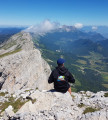
A short but energetic walk that is exposed towards the end. Enjoy the stunning views from the top of Rocher de Roquebrune with its famous ochre colours.

Technical sheet

183384
Creation:
Last update:
Last review:
  • Walking
    Activity: Walking
  • ↔
    Distance: 6.44 km
  • ◔
    Average duration: 2h 50 
  • ▲
    Difficulty: Difficult

  • ⚐
    Return to departure point: Yes
  • ↗
    Vertical gain: + 361 m
  • ↘
    Vertical drop: - 360 m

  • ▲
    Highest point: 359 m
  • ▼
    Lowest point: 13 m

Photos

Description of the walk

The walk starts out at the forest barrier in La Maurette, south of Arena lake, near the Pétignons.

(S/E) Take the GR51 trail (Grande Randonnée – Long Hike) with red and white waymarks to the west. The path climbs up a dry riverbed and then joins a track near some isolated houses.

(1) When the track splits into a fork ahead of you, keep following the GR51 on the right. The path runs alongside the left bank of a river through some undergrowth planted with mimosas.

(2) When you come out from the undergrowth, an unmarked track leads off to the right, to the northeast. There may be a barrier on the ground indicating a private track. Take this track up into the scrubland.

You will be able to see the rocks clearly up ahead of you. To reach the top, you will need to go round them to the left and climb up from the west. The path takes a northwesterly direction and then reaches a crossing in a grove of oak and pine trees.

(3) At the crossing, turn right, towards the northeast and follow the yellow or blue waymarks. The path goes past some ruins, climbs up through the woods, and then comes out at a large rock face. Follow the yellow waymarks to the right of this rock face, still heading northeast.

The slope becomes very steep and you will often need to use your hands. You will reach the foot of a rock face; continue to the left for the last 30 metres with a little easy rock climbing to reach the top.

(4) The three crosses and the survey marker are on your left above the last few rocks you will need to climb.

The return journey is back along the same route.

Waypoints

  1. S/E : km 0 - alt. 13 m - La Maurette, forest barrier
  2. 1 : km 1.18 - alt. 89 m - Basse Rouquaire, three-way junction, follow GR to the right
  3. 2 : km 2.47 - alt. 175 m
  4. 3 : km 3.22 - alt. 333 m - Les Trois Croix
  5. S/E : km 6.44 - alt. 13 m - La Maurette, forest barrier

Practical information

There is no water source along this route.

The end of the climb is difficult between (3) and (4). There are several sections where you will need to make your way carefully or use your hands. The summit is a little dizzying.

In the nearby area

Superb views from the top of Rocher de Roquebrune, with the summits of the Esterel, and the bay of Fréjus - Saint-Raphaël to the east. To the southwest, there are beautiful views over the Massif des Maures.
The changing colours of the rocks in the sun also make it well worth the trip...

 Always stay careful and alert while following a route. Visorando and the author of this walk cannot be held responsible in the event of an accident during this route.

The GR® and PR® markings are the intellectual property of the Fédération Française de Randonnée Pédestre.

Reviews and comments

4.6 / 5
Based on 75 reviews

Reliability of the description
4.5 / 5
Clarity of route map
4.4 / 5
Route interest
4.8 / 5
trainhub
trainhub

N 43.451295° / E 6.615038° - alt. 12 m - km 0
on this road there are 2 good car parks close to each other
one of which, this one, is opposite the start
If you give me your e-mail address, I'll send you a map and a GPX.
See you soon
Hubert

Automatically translated

Jé rôme
Jé rôme

I'm sharing my experience so that future hikers are aware of the problem I encountered. There was no problem finding the starting point for the walk (the Maurette forest gate). However, I never found a car park and parking on the side of the road is forbidden for 6 kilometres. So I wasn't able to do this tour. Message to those who managed to do the walk from this starting point: where did you park?

Automatically translated

trainhub
trainhub

Overall rating : 3.7 / 5

Date of walk : Apr 28, 2025
Reliability of the description : ★★★☆☆ Average
Clarity of route map : ★★★☆☆ Average
Route interest : ★★★★★ Very good
Busy trail : Yes

difficult, vertiginous and dangerous hike, for inexperienced or unskilled walkers
however, a magnificent walk
The signposting on the ascent from the car parks could do with a refresh and the addition of a few judiciously placed markers.
but it's an idea, certainly not a negative comment
going to the cross via the via ferrata is pure happiness, for me and those who were with me
frequented by people in very good physical shape
some dogs turned back .... with their master
thank you

Automatically translated

Yohan Stardeck
Yohan Stardeck

Overall rating : 5 / 5

Date of walk : Mar 01, 2025
Reliability of the description : ★★★★★ Very good
Clarity of route map : ★★★★★ Very good
Route interest : ★★★★★ Very good
Busy trail : No

We did this tour at the end of the day and cut off in the middle of the path on the shortest path (dotted line) in order to climb more quickly, then came back down on the path as indicated. There's a change of scenery, and the climb is fairly easy until you reach the rock face, where you have to use your hands a little to climb up. In the forest between stages 2 and 3, there are alternating passages with small boulders, but be careful where you step as the recent rainfall has tended to move the stones.

Mind you, we went up for the sunset, so we had the right equipment for the return journey under cover of darkness (thermal undershirt, warm jacket, gloves, water, specific night equipment (headlamps, batteries, etc.). We only passed a bike and 2 couples on the way down as we climbed.

It was a good hike (if you see any rubbish along the way, don't hesitate to remove it so that nature remains as it is).

Automatically translated

Nicole61
Nicole61

Overall rating : 4.3 / 5

Date of walk : Feb 16, 2025
Reliability of the description : ★★★★☆ Good
Clarity of route map : ★★★★☆ Good
Route interest : ★★★★★ Very good
Busy trail : No

A very difficult hike for older people. Some steep sections are dangerous, especially in winter when the ground is wet.

Automatically translated

Alfredophilgar
Alfredophilgar

Overall rating : 5 / 5

Date of walk : Sep 08, 2024
Reliability of the description : ★★★★★ Very good
Clarity of route map : ★★★★★ Very good
Route interest : ★★★★★ Very good
Busy trail : Yes

The route to the 3 crosses at the top of the Rocher is perfect. The start, from the Chapelle Saint-Roch, is easy: it climbs gradually, so it's a good warm-up! The going gets tougher as we approach the Rocher. In the forest, the path becomes rockier and the climb more difficult. But we knew we were getting close to our goal, so we persevered. Finally, we reach the pass where chains fixed into the rock will enable us to reach the summit: 373m above sea level! A magnificent panorama lay before us: the reward for our effort! After savouring the moment, we headed back down the same path, as more experienced hikers warned us that the section on the other side was more difficult. All in all, a great hike!

Automatically translated

osiris130
osiris130 ★

Hello Bazog,

It's true that the end of the route is not suitable for dogs.

In order to improve the form, could you tell me more about the difficulties you encountered with the description and itinerary?

Thank you in advance.

Automatically translated

Bazog69
Bazog69

Overall rating : 3.3 / 5

Date of walk : Jul 11, 2024
Reliability of the description : ★★★☆☆ Average
Clarity of route map : ★★☆☆☆ Disappointing
Route interest : ★★★★★ Very good
Busy trail : No

The route is difficult. Dogs are allowed, but the difficulty of some sections means they have to be carried....
More likely to be done with a guide

Automatically translated

provence13
provence13

Overall rating : 4 / 5

Date of walk : Apr 14, 2024
Reliability of the description : ★★★★☆ Good
Clarity of route map : ★★★★☆ Good
Route interest : ★★★★☆ Good
Busy trail : No

Difficult walk, and some sections are equipped with chains to enable you to climb to the 3 crosses.
A very nice walk

Automatically translated

gillesdulac
gillesdulac

Overall rating : 5 / 5

Date of walk : Jan 07, 2024
Reliability of the description : ★★★★★ Very good
Clarity of route map : ★★★★★ Very good
Route interest : ★★★★★ Very good
Busy trail : Yes

very small road, parking problems at la maurette (forest barrier)

Automatically translated

Chanchan A
Chanchan A

Overall rating : 5 / 5

Date of walk : Dec 03, 2023
Reliability of the description : ★★★★★ Very good
Clarity of route map : ★★★★★ Very good
Route interest : ★★★★★ Very good
Busy trail : No

Very nice walk, which I found less difficult than advertised.
A real pleasure and a breathtaking view 😉🤩

Automatically translated

Gilles1960
Gilles1960

Overall rating : 5 / 5

Date of walk : Oct 07, 2023
Reliability of the description : ★★★★★ Very good
Clarity of route map : ★★★★★ Very good
Route interest : ★★★★★ Very good
Busy trail : Yes

A fine hike, fairly short but with some very steep sections, but no great difficulty with appropriate footwear. Panoramic view of the Var at the top.

Automatically translated

philippe remy
philippe remy

Overall rating : 5 / 5

Date of walk : May 29, 2023
Reliability of the description : ★★★★★ Very good
Clarity of route map : ★★★★★ Very good
Route interest : ★★★★★ Very good
Busy trail : Yes

Although this is a short hike, with an ascent of 1 hour 15 minutes and a descent of 1 hour, it is very steep at the end and requires attention on the cabled sections. Take care on the way up as well as on the way down, but the panorama is well worth the diversions.

Automatically translated

Jo Sou
Jo Sou

Overall rating : 4.7 / 5

Date of walk : Apr 16, 2023
Reliability of the description : ★★★★★ Very good
Clarity of route map : ★★★★☆ Good
Route interest : ★★★★★ Very good
Busy trail : Yes

Lovely, sporty hike, especially at the end

Automatically translated

migar
migar
• Last modified:

Overall rating : 5 / 5

Date of walk : Apr 09, 2023
Reliability of the description : ★★★★★ Very good
Clarity of route map : ★★★★★ Very good
Route interest : ★★★★★ Very good
Busy trail : Yes

Easter Sunday, not really a good day to be out on your own.
The difficulties on the way up (and down) make it a good day for a chat.
It's a great walk, for 7 to 77 year-olds, just like in Tintin. No chocolate eggs, but a splendid view from the top. Not recommended for those prone to vertigo, but no real danger, especially with the cables helping (gloves are recommended for the more fragile).
Well done for a great hike.

Automatically translated

Other walks in the area

For more walks, use our search engine .

The GPS track and description are the property of the author. Do not copy them without permission.