Country:

 City:
City:


Limited parking is available in Chapel Stile; please do not park in the streets, as they are narrow and selfish parking blocks access for emergency vehicles. On busy days, you will have to park further afield such as the National Trust car park in Elterwater, which is another 15 minutes' walk away. You could also park in the large car park opposite the New Dungeon Ghyll Hotel and follow the route from there.
This GPX and route is described as starting and finishing at the parking beside the village shop (NY321053). Please note this is only for illustrative purposes to represent the centre of the village. The parking here is for patrons of the shop and tea room only; it is not for long-term parking whilst you go walking.
(S/E) From the parking exit onto the narrow lane which leads up to the church. Turn right and walk uphill. Where the road forks, take the right-hand fork and at the top turn right. Follow the narrow road and when you get to the open fell-side on your left, start to look out for a path and wooden gate on the left.
(1) Go through the gate and ascend the path; there is a stream on the right and the path crosses over this and back at one point. There is a plantation of trees on the far side of the stream; as you get near to the top edge of the plantation, ignore a path which leads off left. Instead go right, dip down slightly towards the trees and then start ascending again until the path meets Meg's Gill.
(2) Cross the gill and follow the far bank uphill for a few metres until you can cross back to a narrow track. Follow the narrow track uphill with the gill on your right; there is one place where you have to use your hands for a short distance. The steepness of the track starts to ease a little, then it bends to the left and ascends more steeply. The steep section is short-lived and soon the gradient eases off and the track underfoot widens. Follow the grassy track over undulating ground with rocky outcrops and good views of the Langdale Valley. Pass a small tarn on its south-west side and ascend a wider grassy track to a cairn.
Note: this latter section has many intersecting grassy paths; some go up to the cairn, some avoid it.
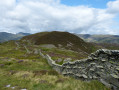
(3) Ahead of you the next rise is Little Castle How. Descend into a col (Swinescar Hawse), which can be boggy and where the path curves left and right to avoid the worst of the bog. You will see a small outcrop with a shepherd's stone shelter (4) (see photo), which is built at the side of a large boulder. The path curves under this shelter and ascends Little Castle How and then around to a small Col under Great Castle How where there is a second cairn.
(5) Now descend gently and follow the path between small tarns. Ahead is Blea Rigg; there are three paths up it, and they are not all obvious at first sight. Try to avoid the left-hand path as it is easy to start descending and end up at Stickle Tarn. Instead, aim to keep to the middle track where it is rockier and where you might need to use your hands again. The track at the top of Blea Rigg becomes more obvious again, but as you descend look out for a boggy depression on the right of the track.
The obvious path goes to the left of the depression, but it then curves to the left and drops down to Stickle Tarn. Instead, at the very start of the depression, take a split right.
(6) Cross the depression at its driest part and follow a faint sheep track to higher ground on the far side. Now follow a narrow path to pass a third cairn.
(7) Ahead the ground rises to Sergeant Man; follow the track passing a fourth cairn and then up to the rocky outcrop which is Sergeant Man.
(9) At the top, take time to scope out the next part of your route which curves around the top of the combe containing Bright Beck. There are a few paths here and the ground can be wet underfoot. Descend from the top of Sergeant Man and head West on a path. Pick your way between any wet or boggy sections to join a wider track which links High Raise to Thunacar Knott; here the path ascends gently and becomes less wet. Follow it to a split.
(10) Take the right-hand path up to Thunacar Knott.
(11) Ahead you will see the obvious rocky outcrop which is Harrison Stickle. The path heads South and is easy to follow, but it soon crosses another boggy section. If this is wet and you can't cross, veer leftwards on narrower tracks towards the slopes which are West of Stickle Tarn. You can skirt the bog here and then follow narrow tracks back to the main track leading up to Harrison Stickle, where you will need to scramble up to gain the top.
Note: This is the route we took; see GPS track.
(12) From the summit, scramble down and retrace your tracks for 100m until you can pick up a track on the left which leads downhill. Veer leftwards again to pick up a better path which has been flagged. This leads you downhill to cross a stream which flows into Dungeon Ghyll. Cross over and follow the path up to Pike of Stickle with Loft Crags on your left. Pike of Stickle can be ascended in a variety of places, but look out on the left for a small rocky platform with a rocky groove above it.
Note: If you do not like scrambling or have a fear of heights, do not go up as the scramble is harder than any you will have done on this walk so far.
If you are ok with scrambling, then the first few feet are the hardest, and once up the groove the angle eases. Enjoy the view of the other Langdale Pikes, including Harrison Stickle and the profile of Gimmer Crag straight ahead.
(13) Descend the same way as you scrambled up, and as you head down the path, look out for a fork in the track. Take the right-hand fork and follow a path up over the top of Gimmer Crag and onto Loft Crag.
(14) From the top of Loft Crag, head down a loose stony path for about 50m towards Harrison Stickle and then take the path which contours the hillside to a cairn.
(15) The path then starts to descend, steeply at first and flagged in places, but it soon eases in angle and is an easy way off the hillside. Take care if wet, as the grass and some of the stones used to make the path and prevent erosion can be slippery if wet. It will lead all the way down to a junction with Dungeon Ghyll. Cross the stream and go through a gate to follow the path down via more gates to the Stickle Barn (now called Lanty Slee's) and New Dungeon Gill Hotel, both of which offer refreshments.
(16) From the New Dungeon Ghyll Hotel, cross the road into the car park on the opposite side and walk to the left-hand corner. Follow a wide track along the valley bottom and between the fields to a T junction with another track.
(17) Turn right and follow the track to cross a bridge. After the bridge, turn left and follow the track beside the Great Langdale Beck to pass the campsite. Just after the campsite, cross a second bridge and turn right to follow a track beneath the Langdale Road and beside some new housing. Do not be tempted up onto the busy road, but keep to the path and head to Thrang Farm. Pass through Thrang Farm and continue along the path, around the back of the primary school, and this will bring you back to the road between the Wainwrights Inn and the parking. Turn left and follow the short section of road back to your car.(S/E)
 Visorando Member
 Easy
Easy