
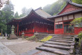
Asamade Kongoshoji Temple

This is an easy hike in the Ise region. The ascent takes place through a very damp and humid forest, especially when weather fronts pass over Japan. At the summit, there is a temple and a shrine to visit and, if the weather is fine, you’ll be treated to a beautiful panoramic view of the bay.

Details

n°110494733
Creation:
Last update:
Last review:
–
  • Walking
    Activity: Walking
  • ↔
    Distance: 3.79 mi
  • ◔
    Average duration: 3h 25 
  • ▲
    Difficulty: Moderate

  • ⚐
    Back to start: No
  • ↗
    Ascent: + 1,909 ft
  • ↘
    Descent: - 305 ft

  • ▲
    Highest point: 1,745 ft
  • ▼
    Lowest point: 33 ft
  • ⚐ Country: Japan
  • ⚑
    Start: N 34.477313° / E 136.75871°
  • ⚑
    End: N 34.459911° / E 136.7912°
  • Hour-by-hour weather

Photos

Description of the walk

We set off from the station to head up to the summit to see Kongosho-ji Temple and the shrine situated at the summit of Adama. We decided to take a taxi back down to the Amasadake Konosho-ji Buddhist temple.

The path is marked by 22 shrines.

Note: we had a picnic at the summit (limited dining options available)

Waypoints

  1. S : mi 0 - alt. 46 ft - Asama Station M76
  2. 1 : mi 0.16 - alt. 36 ft - Crossroads
  3. 2 : mi 0.28 - alt. 69 ft - Uphill path
  4. 3 : mi 0.57 - alt. 108 ft - Uphill path
  5. 4 : mi 1.4 - alt. 837 ft - Turn
  6. 5 : mi 1.74 - alt. 1,296 ft - Fork in the road
  7. 6 : mi 2.08 - alt. 1,601 ft - Tarmac road
  8. 7 : mi 2.42 - alt. 1,739 ft - Route
  9. 8 : mi 2.81 - alt. 1,562 ft - Kongosho-ji Temple
  10. E : mi 3.79 - alt. 1,660 ft - Viewpoint overlooking the sea

Notes

Departure from Ise Station to Asama Station.

Worth a visit

Kongosho-ji Temple

For more walks, use our search engine .

The GPS track and description are the property of this route's author. Please do not copy them without permission.