Piton de Bois Vert or Piton de Bert

This hike offers beautiful views of the Enclos Fouqué and the Plaine des Sables region. We did this hike to see the volcanic eruption of May 2015! To do so, we got up early in the morning to enjoy the best possible view.

Details

193356
Creation:
Last update:
Last review:
  • Walking
    Activity: Walking
  • ↔
    Distance: 12.72 km
  • ◔
    Average duration: 3h 55 
  • ▲
    Difficulty: Moderate

  • ⚐
    Back to start: Yes
  • ↗
    Ascent: + 93 m
  • ↘
    Descent: - 94 m

  • ▲
    Highest point: 2,348 m
  • ▼
    Lowest point: 2,254 m

Photos

Description of the walk

From Bourg-Murat, head towards the volcano. Park at the Piton de Bert trail car park, 2 kilometres after Pas des Sables.

(S/E) Take the trail that leads to Piton de Bois Vert and Nez Coupé du Tremblet. This is theGR® R2 trail, marked in red and white. The trail is rocky but almost flat.

(1) Pass in front of the Chisny cave.

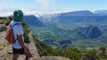
(2) After thirty minutes of walking, the trail approaches the rampart, revealing Piton de la Fournaise on the left. The trail winds gently through the rocks, not far from the track.

(3) After an hour's walk, you will come across a path on the right that leads to the Basse Valé lodge via Piton Lardé.

Continue straight ahead on the path that runs along the rampart of the enclosure (still theGR® R2), before arriving at Piton de Bert after about 30 minutes.

(4) Take the path back in the opposite direction. On the way back, you will see Morne Langevin. A quick glance behind you will allow you to see the path you have travelled before reaching the car park (S/E), located at the foot of Demi-Piton and Piton Chisny.

Waypoints

  1. S/E : km 0 - alt. 2,333 m - Car park
  2. 1 : km 0.38 - alt. 2,340 m - Chisny Cave
  3. 2 : km 2.31 - alt. 2,314 m - Start of the rampart
  4. 3 : km 4.81 - alt. 2,254 m - At the fork, continue straight ahead.
  5. 4 : km 6.34 - alt. 2,263 m - Piton de Bois Vert
  6. S/E : km 12.72 - alt. 2,333 m - Car park

Notes

For this hike, you have two choices: follow the trail (as we did) or the track. Both follow each other, intersect numerous times and lead to Piton de Bois Vert. The trail sometimes follows sections of the track.

Bring a hat and water. I recommend setting off at night to see the eruptions! It's much better than seeing the same thing in broad daylight (photos 18, 19, 20 and 21)! Bring warm clothing, gloves, a hat and a scarf if you come at night (especially in winter)! The slag on the trail can be hard on your ankles! It is possible to spend the night at the lodge du Volcan, a few kilometres from the starting point.

Worth a visit

Nature treats us to a beautiful sunrise with no clouds to block our view (photo 3). On our right, we can already see our destination: Piton de Bois Vert (or Piton de Bert, photo 4). The trail is still flat and stony, but in addition to that, we can see that there is black ice and ice crystals all the way to Piton de Bert! (photo 2).

That morning, the trail was very busy. We then head towards the edge of the rampart. Admittedly, the view of Piton de la Fournaise is magnificent (photo 9), but there is no lava flow... We can only see smoke escaping from the fault (photo 10). Too bad, we were expecting better!

You can continue towards Tremblet or Basse Vallée! Why not go to Pas de Bellecombe, which offers a view of Piton de la Fournaise (the most visited place on the island), or to Puys Ramond. To do this, take the path on the right when you reach Piton de Bois Vert. It will take you an extra two hours there and back. The hike also passes by the Chisny cave, a geological curiosity located at the start of the trail.

Always be cautious and plan ahead when you're outdoors. Visorando and the author of this route cannot be held responsible for any accidents occurring on this route.

The GR® and PR® markings are the intellectual property of the Fédération Française de Randonnée Pédestre.

Reviews and comments

5 / 5
Based on 11 reviews

Reliability of the description
5 / 5
Ease of following the route
5 / 5
Route interest
4.9 / 5
User 9478255

Overall rating : 4.7 / 5

Date of your route : Mar 30, 2026
Reliability of the description : ★★★★★ Very good
Ease of following the route : ★★★★★ Very good
Route interest : ★★★★☆ Good
Very busy route : No

Machine-translated

User 26147702
• Edited:

Overall rating : 5 / 5

Date of your route : Aug 12, 2025
Reliability of the description : ★★★★★ Very good
Ease of following the route : ★★★★★ Very good
Route interest : ★★★★★ Very good
Very busy route : No

This hike was a great alternative to climbing Piton de la Fournaise, which was closed, as it offers a magnificent view of the enclosure. I actually think the view is better than from Pas de Bellecombe.

The hike is very accessible for beginner hikers as there is almost no elevation gain.

I did it in 3.5 hours, taking my time, but if you have less time, you can turn back before the Piton de Bert without missing the best views.

It was between 15 and 20 degrees, with a slight breeze, so very pleasant. However, be sure to bring a hat and sunscreen because the sun is strong without you realising it.

Very few hikers!

Machine-translated

Ziggy78
Ziggy78

Overall rating : 5 / 5

Date of your route : Jan 03, 2025
Reliability of the description : ★★★★★ Very good
Ease of following the route : ★★★★★ Very good
Route interest : ★★★★★ Very good
Very busy route : No

Warm clothing in winter but sun protection is essential in summer: hat, sun cream...and water +++
At an altitude of over 2,200 metres, you don't feel the sun burning you, but unfortunately you realise this too late... There are a few spots in the shade (you have to find them) for a picnic.

Machine-translated

Raph26120
Raph26120

Overall rating : 5 / 5

Date of your route : Oct 02, 2022
Reliability of the description : ★★★★★ Very good
Ease of following the route : ★★★★★ Very good
Route interest : ★★★★★ Very good
Very busy route : Yes

We did this hike while the eruption was happening. It's not difficult.
We did it in the evening so we could also watch the eruption at night.
The route is littered with rocks and stones, so I would advise against going without trainers or hiking/trail shoes.
Be sure to bring warm clothing, as the temperature drops rapidly at nightfall at 2,300 metres (4°C when we were there).
A headlamp or other means of lighting is essential.
The route is not marked, but if there are many people on the trail, you will see a string of lights at night

Machine-translated

Coco75mg
Coco75mg

Overall rating : 5 / 5

Date of your route : Apr 19, 2022
Reliability of the description : ★★★★★ Very good
Ease of following the route : ★★★★★ Very good
Route interest : ★★★★★ Very good
Very busy route : No

We did this route with our 12- and 15-year-old daughters, and it wasn't particularly difficult. On that day, it was essential to remember to bring a hat, sun cream and water, as it was very hot and the trail is not shaded.
The car park was deserted, and we only encountered two other hikers.
We were surprised to see the fumaroles from the last eruption in December 2021. At first, we thought they were clouds, but as we approached Piton de Bert, our doubts were dispelled!

Machine-translated

Stephpich
Stephpich
• Edited:

Overall rating : 5 / 5

Date of your route : Jul 30, 2020
Reliability of the description : ★★★★★ Very good
Ease of following the route : Not used / Not applicable
Route interest : ★★★★★ Very good
Very busy route : No

Done today. Very pleasant weather; very easy and beautiful hike. The view from Piton de Bert is stunning. The view along the entire route is magnificent. 3½ hours at a normal walking pace. Suitable for children. I recommend it.

Machine-translated

eurisko69
eurisko69

Overall rating : 5 / 5

Date of your route : Nov 05, 2018
Reliability of the description : ★★★★★ Very good
Ease of following the route : ★★★★★ Very good
Route interest : ★★★★★ Very good

The first part is a little "rough" (walking shoes are recommended but not essential as the second part is much smoother and flatter).
We were unable to hike in the caldera due to an ongoing eruption, but the alternative route via Piton de Bert is still well worth it, offering beautiful panoramic views of the caldera throughout the hike and easy views of the volcano.
Just follow the GR trail. No particular difficulty.
Thanks to the author for the details provided.

Machine-translated

lmichaelian
lmichaelian

Overall rating : 5 / 5

Date of your route : Oct 16, 2018
Reliability of the description : ★★★★★ Very good
Ease of following the route : ★★★★★ Very good
Route interest : ★★★★★ Very good

A superb hike that is definitely worth doing!!!

Machine-translated

sarah.faiz
sarah.faiz

Overall rating : 5 / 5

Date of your route : Sep 23, 2018
Reliability of the description : ★★★★★ Very good
Ease of following the route : ★★★★★ Very good
Route interest : ★★★★★ Very good

Ideal trail for viewing the erupting volcano. Easy hiking trail and almost flat footpath that follows it.

Machine-translated

Brigbrig
Brigbrig

Overall rating : 5 / 5

Date of your route : Sep 24, 2018
Reliability of the description : ★★★★★ Very good
Ease of following the route : ★★★★★ Very good
Route interest : ★★★★★ Very good

Beautiful views of the enclosure and the ongoing eruption

Machine-translated

Orando974
Orando974 ★
• Edited:

Piton de la Fournaise has been erupting since 14 September 2018. This is the hike you need to take to see the eruption It can be seen from (2)

Machine-translated

alainrun974
alainrun974

Overall rating : 5 / 5

Date of your route : Apr 29, 2018
Reliability of the description : ★★★★★ Very good
Ease of following the route : ★★★★★ Very good
Route interest : ★★★★★ Very good

I consider this hike to be easy, provided you have the minimum equipment required (walking shoes, PETZL headlamp for night hiking, etc.). From the FOC FOC car park, it takes about half an hour to reach the ramparts of the enclosure. For me, this first part is the most "rugged", if you can describe it that way, although it is not without its difficulties. The second part, up to Piton de Bert, is much easier going. It is actually a groomed track that runs along the ramparts and is also used by emergency vehicles (fire engines) stationed at the FOC FOC car park during volcanic eruptions. The view of the enclosure remains magnificent throughout the hike. Viewing areas are indicated during eruptions. The walking times for the round trip from the FOC FOC car park are as indicated on the map diagram. They can be reduced for those who walk quickly.

Machine-translated

Orando974
Orando974 ★

For your stay: If you want to extend your trip, once you reach Piton de Bois Vert, you can either:

-continue to Nez Coupez du Tremblet by following the path that runs along the rampart (allow at least 3 extra hours for the round trip, see the hike at: https://randopitons.re/randonnee/1368-ne...), or to the village of Tremblet (allow at least 8 additional hours round trip, see the hike at: https://randopitons.re/randonnee/1064-tr...

-or continue towards Basse Vallée by turning right at Piton de Bert. Allow at least 8 hours extra for the round trip. See the hike at: https://randopitons.re/randonnee/1379-ba...

Machine-translated

marcsejour
marcsejour
• Edited:

A bit too easy for me, but maybe we'll do it when we go to Réunion in winter 2017. Thank you.

Machine-translated

Other walks in the area

For more walks, use our search engine .

The GPS track and description are the property of this route's author. Please do not copy them without permission.