


Park in the car park near the bus shelter in the village of Ordonnaz.
(S/E) Turn left onto the CD 94 towards Lompnas. You will reach a large hairpin bend. Turn left onto the yellow-marked path that leads to Combe d'Innimond. You will soon come to a crossroads.
(1) Turn right, following the yellow markings. Then enter the woods to find another fork in the path.
(2) Continue on the left branch. Exit the woods and, in the clearing, you will reach a multiple crossroads where several trails meet: yellow, orange and the Assise trail. Continue straight ahead to reach the Moïlda Cave. To do this, go straight across the meadow and take the small gully further on. Reach the edge of the woods on the right to find the entrance to the cave.
(3) With your back to the cave entrance, turn right into the meadow to reach the stony path. Follow it to the right until you reach the next crossroads. Turn right onto the path marked in blue and follow the signs for Lompnas. You will reach another T-junction.
(4) Continue to the right and follow the sign for "Lompnas 3.3 km". Ignore the three paths branching off to the left. At the next crossroads, follow the blue markings to the left, signposted "Lompnas 2.5 km". A little further on, ignore the white ribbon tied around a tree. It marks a barely visible path on the left. Follow the blue dots painted on the trees to reach a path. Turn left and continue to the entrance to the Grotte de la Jacquette.
(5) Retrace your steps and follow the path to the intersection with the Lompnas gravel road. Turn left. At the next crossroads, continue straight ahead to the viewpoint, signposted.
(6) Retrace your steps. Continue left on the path, still marked in blue, to reach the village of Lompnas.
(7) Cross the main street and then take Rue de Gravignoli. Atthe second crossroads, turn left into Impasse de la Maladière. At the crossroads, continue straight ahead. At the next crossroads, leave the path on the right. Then continue straight ahead and ignore the dead end on the right.
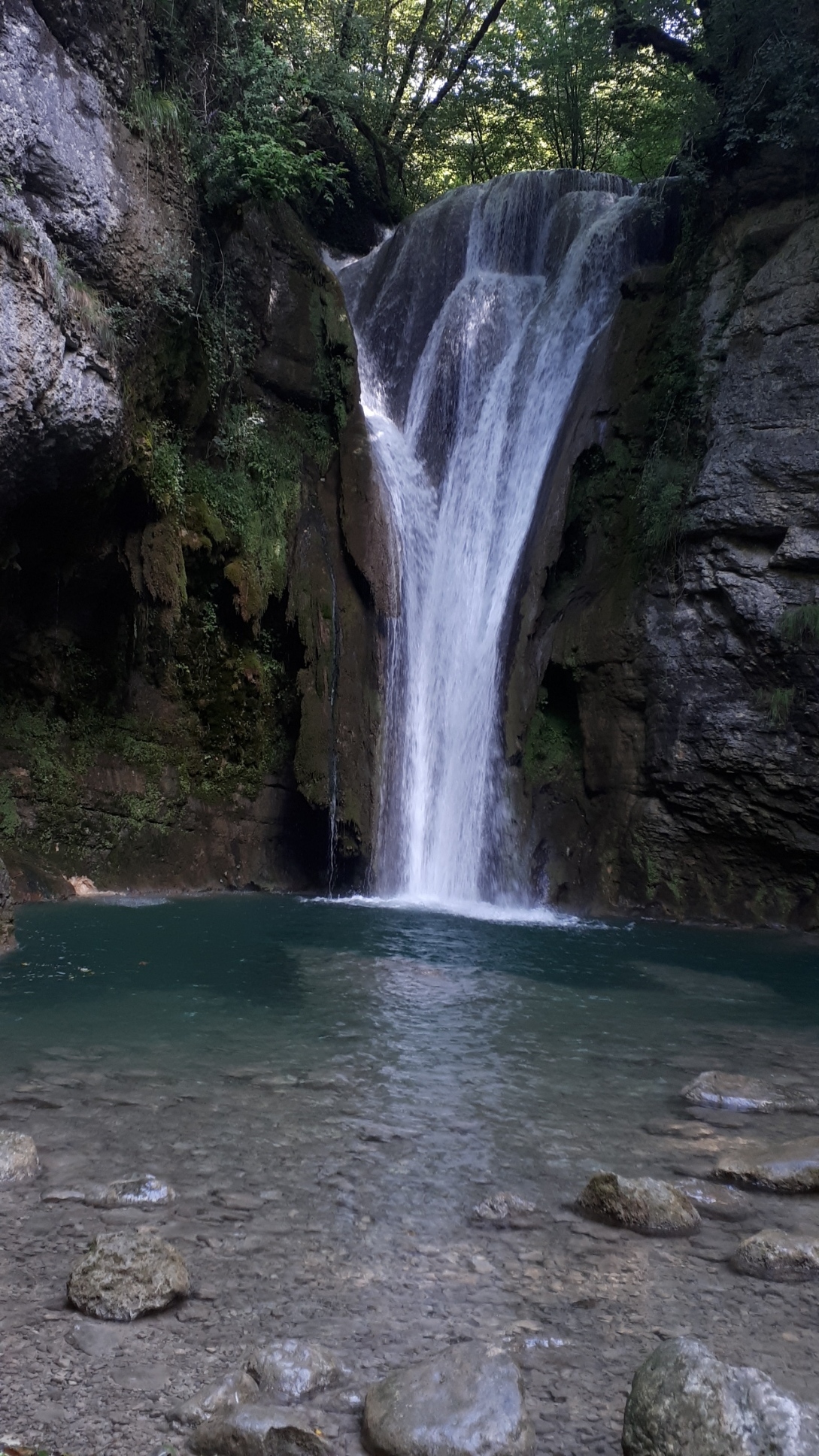
Just after the bridge over the Ruisseau du Gros Pertuis, take the small path on the left and follow the stream. Here you will see pretty potholes and small tufa waterfalls. Retrace your steps back to the bridge and continue along the path on the left.
(8) At the hairpin bend to the left, go through the fence and follow the path to reach the pretty turquoise waterfall. Retrace your steps and continue on the path to the right. Turn right at the next crossroads and follow the yellow markings. At the metal barrier, go right and follow the Ruisseau de la Brive stream, following the yellow markings. After the ruins of the mill, stay on the path to the left.
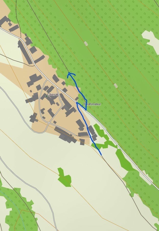
(9) Descend to the large waterfall, then continue along the path to a small car park. Leave the yellow markings and take the path on the right, marked with grangeons*. Join the small tarmac road, continue to the right and then right again, 120 m further on, onto the grassy path that climbs up to the hamlet of Chosaz.
(10) Continue left along the main street. After the "50 rappel" sign, turn right onto the grassy path and then, a little further on, take the path climbing up to the right. At the stony track, veer left and walk to the entrance to a pasture. Follow the hedge to the end of the meadow and then join a stony path on the right. Turn right. You will come to a crossroads marked by a cross.
(11) Continue straight ahead to reach the cemetery in the village of Lompnas. Turn left and follow the signs for "Chanaux 3.3 km". You will soon reach the crossroads at a farm.
Walk to the right towards Bois de la Morgne 2.5 km, then further up the hill towards Ordonnaz 5 km, and finally towards La Rivolière 4.7 km. Follow the poorly maintained path to the fence, which you should follow to the right. Return to the main path.
(12) Turn left to enter the woods, heading north. Stay on this path to reach the Gouffre de la Morgue crossroads after a right-hand bend.
(13) Turn left to reach this chasm.
(14) Gouffre de la Morgue. Retrace your steps to the previous crossroads.
(13) Turn left, continue straight ahead and reach the edge of the woods.
(15) Walk along the edge of the woods, then enter the woods again. Continue, ignoring a path on the right, to reach the crossroads of the path you took on the way there.
(2) Turn left and follow the same route as on the way out, following the yellow markings.
(1) Leave the yellow markings and take the path on the right. Continue until you reach the Renaudière crossroads and theGRP® de Lhuis et d'Izieu. Turn left and follow the red and yellow markings to return to the car park near the Ordonnaz bus shelter (S/E).


