


Refine your search for walks in Gare de La Plume
Gare de La Plume walks


 Laplume from top to bottom
 Visorando Member
 5.17 mi
 +564 ft
 -571 ft
 2h 50
2h 50
 Easy
Easy
 Departure from Laplume (Lot-et-Garonne)
From the sports centre, this route follows the nature trail towards the village. After passing through the village with its information boards, you’ll head towards the 10th-century former church of Cazeaux before descending into the valley, which features five small irrigation lakes.
Walks near Gare de La Plume
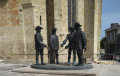
Castelnau-sur-l'Auvignon – Montréal-du-Gers
 16.35 mi
+1,148 ft
-1,404 ft
8h 30
16.35 mi
+1,148 ft
-1,404 ft
8h 30
 Difficult
Departure from Castelnau-sur-l'Auvignon (Gers)
Difficult
Departure from Castelnau-sur-l'Auvignon (Gers)
Thirty-seventh stage of the Way of St James. On this fairly long stage, you start off walking along undulating, grassy paths to Condom, a small town steeped in history and full of life. Your route then takes you over hill and dale, surrounded by fields of sunflowers and vineyards in the Armagnac region, to Montréal-du-Gers.
Please note: in wet weather, some sections can be very muddy and slippery.