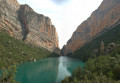
Between Catalonia and Aragon, the Congost de Mont-Rebey from Petrusa

As you walk up the eastern bank of the River Noguera Ribagorçana, you will gradually enter a gorge formed by two cliffs several hundred metres high, which become so narrow and steep that the path had to be carved directly into the rock.
Whether the reservoir is low or high, this walk will offer you stunning views that are sure to make it one of the most beautiful walks you can take in this part of Spain.
Please read the practical information carefully before setting off.

Details

n°31473611
Creation:
Last update:
Last review:
  • Walking
    Activity: Walking
  • ↔
    Distance: 9.12 mi
  • ◔
    Average duration: 7h 35 
  • ▲
    Difficulty: Difficult

  • ⚐
    Back to start: Yes
  • ↗
    Ascent: + 3,845 ft
  • ↘
    Descent: - 3,839 ft

  • ▲
    Highest point: 2,671 ft
  • ▼
    Lowest point: 1,634 ft

Photos

Description of the walk

The walk starts from a stony/dirt car park below the road, which has plenty of spaces. See the practical information section for details on how to get to this car park.

(S/E) Leave the car park, turn left and follow the road for about 700 m to the “Pas de la Pardina”, where there is a car park (which may be closed off).

(1) Take the path that descends gently towards the east.
Soon, this path will descend steeply in hairpin bends to the bottom of a small valley, then climb up the other side, now heading generally northwards (as with the entire outward journey).
Follow this ascending path for about 250 m.

(2) At a Y-junction, turn right, towards “Congost de Mont Rebey”.
Continue uphill until the path runs beneath an overhanging cliff.

(3) Continue along this path for just over 1.5 km. It will soon make a first turn to the right then a first turn to the left, before continuing without really climbing until it reaches some house ruins: the “Mas de Carlets”.

(4) From here, a long, descending path (quite steep in places and through woodland) leads to the junction where you can head down towards a suspension bridge.

(5) For now, ignore the path leading off towards the bridge and continue northwards towards the gorge visible in the distance (there is a fairly steep ascent, but it is easy to climb).

(6) The entrance to the narrowest part of the gorges is via a section that looks challenging. Although it is tricky, a cable provides support. And this is the only slightly ‘acrobatic’ section because, although the path is carved into the cliff face beyond this point, it is much wider and presents no real difficulty, except for those prone to vertigo.
Continue along this path, which runs alongside the gorge, and enjoy the view until you reach the gorge’s exit.

(7) Once you reach this point, you can stop for a drink and a picnic before heading back the other way.

(5) This time, take the path on the right to descend into the valley.

(8) At the bottom, turn round and head back to the car park, following the same route back as on the way there (S/E).

Waypoints

  1. S/E : mi 0 - alt. 2,198 ft - Large car park at Petrusa
  2. 1 : mi 0.48 - alt. 2,051 ft - Path leading down towards the east
  3. 2 : mi 0.76 - alt. 1,860 ft - Head towards Congost Mont Rebey
  4. 3 : mi 1.23 - alt. 2,316 ft - Towards the ruins of the “Mas de Carlets”
  5. 4 : mi 2.26 - alt. 2,464 ft - Path leading down through the forest
  6. 5 : mi 3.05 - alt. 2,008 ft - Northwards towards the gorge
  7. 6 : mi 3.28 - alt. 1,808 ft - Exposed gorges, but manageable
  8. 7 : mi 4.16 - alt. 1,673 ft - Turn back for the gorge section
  9. 8 : mi 5.73 - alt. 1,673 ft - Turn back at the suspension bridge
  10. S/E : mi 9.12 - alt. 2,205 ft - Large car park at Petrusa

Notes

To reach the car park (S/E), you need to follow a narrow track (there are a few places where vehicles can pass each other), with two sections where the road slopes quite steeply; you’ll need to drive at a (very) slow pace – or even let passengers out to lighten the vehicle. This track starts at the hamlet of Corçà and is about 1.5 km long. Corça itself is accessible via a track/road in fairly poor condition, approximately 6 km long, which joins the C12 leading to Ager.
There are three possible access points for this walk, but for our vehicle (a motorhome), this was the most suitable.
The other access point, via the Montfalco inn to the west, shortens the distance and allows you to start the walk from the top (provided the footbridges are open).
The third possible starting point is the Masieta car park, which offers the shortest and easiest route to the Congost de Mont Rebei (less than an hour’s walk). However, there is a height restriction at the car park and, on busy days, you must book your parking space in advance online (according to the latest information).

Between (3) and (5), depending on the season, watch out for the numerous ‘trains’ of processionary caterpillars. Do not touch them as they cause a severe stinging sensation.

Make sure you bring water and provisions for this walk, as well as a good pair of walking shoes.

Please note: those prone to vertigo should avoid this route, particularly once you enter the gorges.

Plan this walk for good weather.

Once inside the gorges, GPS signal reception can be unreliable.
The route provided here has been corrected to remove obvious errors (it used to take us back and forth across the river several times). Also, the markers shown on the map may differ slightly from the actual locations. However, finding the path should not present any particular difficulty.

Worth a visit

(8) If the footbridges are open, you can choose to climb them (thrills guaranteed), but bear in mind that you’ll have to come back the same way and that there are still many kilometres and a significant elevation gain to cover.
In our case, they were closed for maintenance; all morning a helicopter shuttled back and forth to transport materials, so we turned back. But we didn’t regret heading down, as the view from the bridge over the gorge is truly impressive (perhaps even more so because there was very little water in the river, which emphasised the contrast and the depth of the landscape).

If you haven’t already, do visit the Montfalco footbridges.

Also worth doing: the Finestras Walls from Montfalco. A natural wonder – veritable vertical walls of standing stones – described in this walk

There are also several via ferrata routes in the area.

Reviews and comments

5 / 5
Based on 1 review

Reliability of the description
5 / 5
Ease of following the route
5 / 5
Route interest
5 / 5
ferrari174
ferrari174

Not done

Machine-translated

FredF
FredF

Overall rating : 5 / 5

Date of your route : Nov 06, 2023
Reliability of the description : ★★★★★ Very good
Ease of following the route : ★★★★★ Very good
Route interest : ★★★★★ Very good
Very busy route : No

I did this route over the All Saints’ Day holiday, so it wasn’t too crowded. But I reckon it must be absolutely heaving in the summer. However, because of the ongoing drought, the stream is almost dry. So it’s not nearly as pretty. It’s no longer the idyllic scene you might picture from looking at the photos. It’s still very impressive, though.
The detour to the footbridge and the steps leading up to the mountain hut is definitely worth it.

Machine-translated

Other walks in the area

For more walks, use our search engine .

The GPS track and description are the property of this route's author. Please do not copy them without permission.